
AVERAGE AND WE HAVE THAT STIFF BREEZE. THIS TYPE OF WEATHER IS GOING TO BE AROUND THROUGHOUT MUCH OF THE WEEK. SOME DAYS WILL BE COOLER THAN OTHERS, SOME DAYS WILL BE WINDIER THAN OTHERS. WE WILL HAVE SOME OPPORTUNITIES FOR SOME PASSING SHOWERS AT TIMES THIS WEEK. THE NEXT BEST CHANCE WILL BE LATE TOMORROW AFTER SUNSET. ENJOY THE MILDER WEATHER WHILE IT LASTS BECAUSE A BIG COOLDOWN IS COMING EARLY NEXT WEEK. WE’RE TALKING TEMPERATURES BACK DOWN INTO THE 40S FOR HIGHS. BY THE TIME WE GET INTO MONDAY, BUT OUTSIDE RIGHT NOW WE’RE CLOSE TO 60 DEGREES AT THE LUNCH HOUR IN CARLISLE. NOTICE THAT AIR INCREDIBLY DRY WITH DEW POINTS IN THE 20S AND THE GUSTS STILL GREATER THAN 20MPH. SO THAT’S A COMBINATION WHERE YOU PROBABLY SHOULDN’T DO ANY BURNING OUTSIDE. I KNOW A LOT OF PEOPLE ARE TRYING TO CLEAN UP THE LEAVES IN THEIR YARD. JUST DON’T RECOMMEND IT THROUGH THE DAY TODAY BECAUSE IT IS SO DRY. SO WE HAVE AN ELEVATED RISK FOR SOME WILDFIRE SPREAD THROUGH THE DAY TODAY. TEMPERATURES WILL TOP OFF IN THE LOW TO MID 60S WITH THOSE WIND GUSTS POSSIBLY UP TO NEAR 30MPH. AT TIMES. THE WINDS WILL SLOWLY RELAX AFTER SUNSET, SO IT’S GOING TO BE A CALMER NIGHT TONIGHT. IT’S ALSO GOING TO BE COOL WITH TEMPERATURES DOWN INTO THE 30S. REMEMBER, WE HAVE THAT BRIGHT FULL MOON AS WE GO THROUGH THE NIGHT TONIGHT. AND THEN FOR TOMORROW, MORE CLOUDS WILL BE AROUND, BUT IT’S STILL GOING TO BE MOSTLY SUNNY OUT THERE. WINDS WILL PICK BACK UP AS WE HEAD THROUGH THE AFTERNOON, AND HIGHS TOMORROW WILL BE IN THE UPPER 60S. A FEW SPOTS WILL MAKE A RUN AT 70 DEGREES. IT’S AFTER SUNSET. WE COULD SEE SOME SPOTTY SHOWERS. I THINK THE BEST CHANCE WILL COME AFTER 8:00. THURSDAY LOOKS TO BE DRY AND THEN SCATTERED SHOWERS. BETTER CHANCES FOR SOME SHOWERS RETURN LATE IN THE EVENING FRIDAY. SOME OF THOSE SHOWER CHANCES WILL LINGER INTO SATURDAY MORNING, WITH TEMPERATURES TOPPING OFF IN THE LOWER 60S. WE’LL HAVE BETTER CHANCES FOR SOME SHOWERS AROUND FOR YOUR SUNDAY. MORE CLOUD COVER WILL BE OUT THERE, BUT STILL RELATIVELY MILD, WITH HIGHS IN THE UPPER 50S. SINCE WE HAVE CLEAR SKIES, ALL IS QUIET ON LIVE LOCAL RADAR, BUT MAN, THE WINDS HAVE BEEN WHIPPING OUT THERE. IT HAS BEEN A BREEZY DAY WITH WIND GUSTS UP TO 31MPH IN HARRISBURG. CLOSE TO THAT IN LANCASTER DURING THE AFTERNOON. HERE’S A LOOK AT THE CURRENT WIND SPEEDS. THESE ARE WINDS AVERAGED OUT OVER TWO MINUTES RIGHT NOW AT 16MPH IN CHAMBERSBURG, 19MPH FOR YOU FOLKS IN ELIZABETHTOWN, SEVEN MILES PER HOUR IN LEBANON. BUT WE ARE SEEING SOME GUSTS IN EXCESS OF 20MPH, UP TO 25MPH IN ELIZABETHTOWN, 31 MILE PER HOUR GUSTS REPORTED IN LEBANON, 50MPH IN FREDERICKSBURG, TEMPERATURES ACROSS MUCH OF THE VALLEY SITTING IN THE UPPER 50S TO LOWER 60S. WE WILL CONTINUE TO SEE A GORGEOUS AFTERNOON OUT THERE. YOU CAN SEE THAT MILD WEATHER STRETCHES PRETTY FAR OFF TO OUR WEST. STILL IN THE 70S RIGHT NOW IN DALLAS AND MID 60S IN KANSAS CITY AND 50S IN THE DAKOTAS. BUT WHAT WE’RE WATCHING IS THAT THICKER CLOUD COVER BUILDING ACROSS THE ROCKIES. THAT’S A FAST MOVING STORM THAT’S GOING TO SCOOT ACROSS RIGHT ALONG THE CANADIAN BORDER AND BE ON OUR DOORSTEP BY LATE TOMORROW EVENING. SO LOTS OF SUNSHINE OUT THERE FOR YOUR TUESDAY. JUST HOLD ON TO YOUR HAT AS IT IS GOING TO BE A BREEZY DAY. WINDS WILL RELAX AFTER SUNSET. TOMORROW IS GOING TO BE NEARLY THE SAME, BUT THANKS TO THE CHANGE IN THE WIND DIRECTION, IT IS GOING TO BE WARMER OUT THERE. BUT HERE WE ARE. WE’LL STOP THE CLOCK JUST BEFORE 8:00. WE COULD SEE SOME SPOTTY SHOWERS AS THIS COLD FRONT APPROACHES, BUT NOT LOOKING FOR MUCH RAIN OUT OF THAT FRONT. DRIER WEATHER WILL RETURN FOR YOUR THURSDAY AND TEMPERATURES GET KNOCKED BACK DOWN CLOSER TO SEASONAL AVERAGES. RAIN CHANCES GO BACK UP LATE IN THE DAY. ON FRIDAY, THEY’LL BE OUT THERE AGAIN SATURDAY MORNING. I THINK SATURDAY EVENING IS DRY. SUNDAY STARTS OFF DRY, BUT SHOWERS RETURN. AND THEN HERE COMES THAT COOLER WEATHER. WE’RE TALKING HIGHS ONLY IN THE 40S FOR MONDA
Wind advisory, high wind watch issued for South-Central Pennsylvania

Updated: 1:43 PM EST Nov 4, 2025
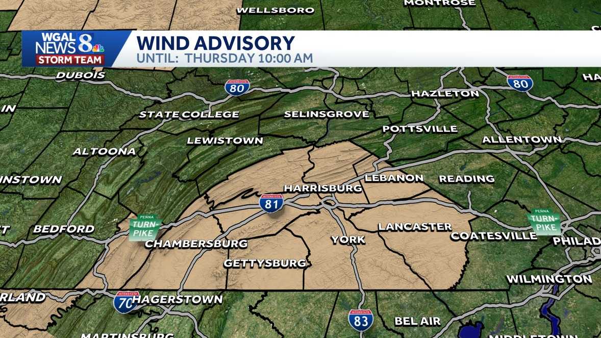
A wind advisory and high wind watch has been issued for much of South-Central Pennsylvania.Wind advisoryThe advisory will be in effect for the following counties from 1 p.m. Wednesday to 10 a.m. Thursday.AdamsCumberlandDauphinFranklinLancasterLebanonPerryYorkThe WGAL News 8 Storm Team has designated Wednesday as an Impact Day, meaning the day’s weather could disrupt your normal daily schedule or routine.What to expectWest winds of 15 to 25 mph, with gusts reaching up to 45 mph.Potential for unsecured objects to be blown around.Tree limbs may be damaged, leading to possible power outages.WhenBegins: 1 PM Wednesday, November 5, 2025Ends: 10 AM Thursday, November 6, 2025Impacted cities, townsImpacted locations include Lancaster, Lebanon, Gettysburg, Chambersburg, Carlisle, York, Hershey, McConnellsburg, Newport, and Harrisburg.Safety tipsExercise caution while driving, especially in high-profile vehicles that are more susceptible to strong winds.Secure outdoor items like patio furniture, trash bins, and holiday decorations to prevent them from being blown away.Stay updated on local weather conditions and prepare for potential disruptions caused by the gusty winds.High wind watchA high wind watch has been issued Juniata and Mifflin counties as well as numerous other Pennsylvania counties (see map below). It will be in effect from 1 p.m. Wednesday to 10 a.m. Thursday. Key details of the forecast:What to expect:West winds of 20 to 30 mph, with gusts reaching up to 60 mph.Isolated gusts exceeding 60 mph are possible, particularly during thunderstorms on Wednesday afternoon and evening.Areas affected:Northern and Southern Clinton, Centre, Lycoming, Union, Snyder, Montour, Northumberland, Columbia, Schuylkill, and surrounding counties.Timing:The strongest winds are expected to develop Wednesday afternoon and persist through Thursday morning.Potential impacts:Downed trees and power lines, leading to widespread power outages.Difficult travel conditions, especially for high-profile vehicles.Safety tips:Secure loose outdoor objects, such as patio furniture and holiday decorations, to prevent them from becoming projectiles.Use extra caution while driving, particularly in high-profile vehicles.Stay updated on local weather alerts and prepare for possible power outages.Be prepared for rapidly changing conditions, especially if thunderstorms develop.
A wind advisory and high wind watch has been issued for much of South-Central Pennsylvania.
Wind advisory
The advisory will be in effect for the following counties from 1 p.m. Wednesday to 10 a.m. Thursday.
AdamsCumberlandDauphinFranklinLancasterLebanonPerryYork
The WGAL News 8 Storm Team has designated Wednesday as an Impact Day, meaning the day’s weather could disrupt your normal daily schedule or routine.
What to expect
West winds of 15 to 25 mph, with gusts reaching up to 45 mph.Potential for unsecured objects to be blown around.Tree limbs may be damaged, leading to possible power outages.

WhenBegins: 1 PM Wednesday, November 5, 2025Ends: 10 AM Thursday, November 6, 2025Impacted cities, towns
Impacted locations include Lancaster, Lebanon, Gettysburg, Chambersburg, Carlisle, York, Hershey, McConnellsburg, Newport, and Harrisburg.
Safety tips
Exercise caution while driving, especially in high-profile vehicles that are more susceptible to strong winds.
Secure outdoor items like patio furniture, trash bins, and holiday decorations to prevent them from being blown away.
Stay updated on local weather conditions and prepare for potential disruptions caused by the gusty winds.
High wind watch
A high wind watch has been issued Juniata and Mifflin counties as well as numerous other Pennsylvania counties (see map below). It will be in effect from 1 p.m. Wednesday to 10 a.m. Thursday.

Key details of the forecast:What to expect:West winds of 20 to 30 mph, with gusts reaching up to 60 mph.Isolated gusts exceeding 60 mph are possible, particularly during thunderstorms on Wednesday afternoon and evening.Areas affected:Northern and Southern Clinton, Centre, Lycoming, Union, Snyder, Montour, Northumberland, Columbia, Schuylkill, and surrounding counties.Timing:The strongest winds are expected to develop Wednesday afternoon and persist through Thursday morning.Potential impacts:Downed trees and power lines, leading to widespread power outages.Difficult travel conditions, especially for high-profile vehicles.Safety tips:Secure loose outdoor objects, such as patio furniture and holiday decorations, to prevent them from becoming projectiles.Use extra caution while driving, particularly in high-profile vehicles.Stay updated on local weather alerts and prepare for possible power outages.
Be prepared for rapidly changing conditions, especially if thunderstorms develop.