
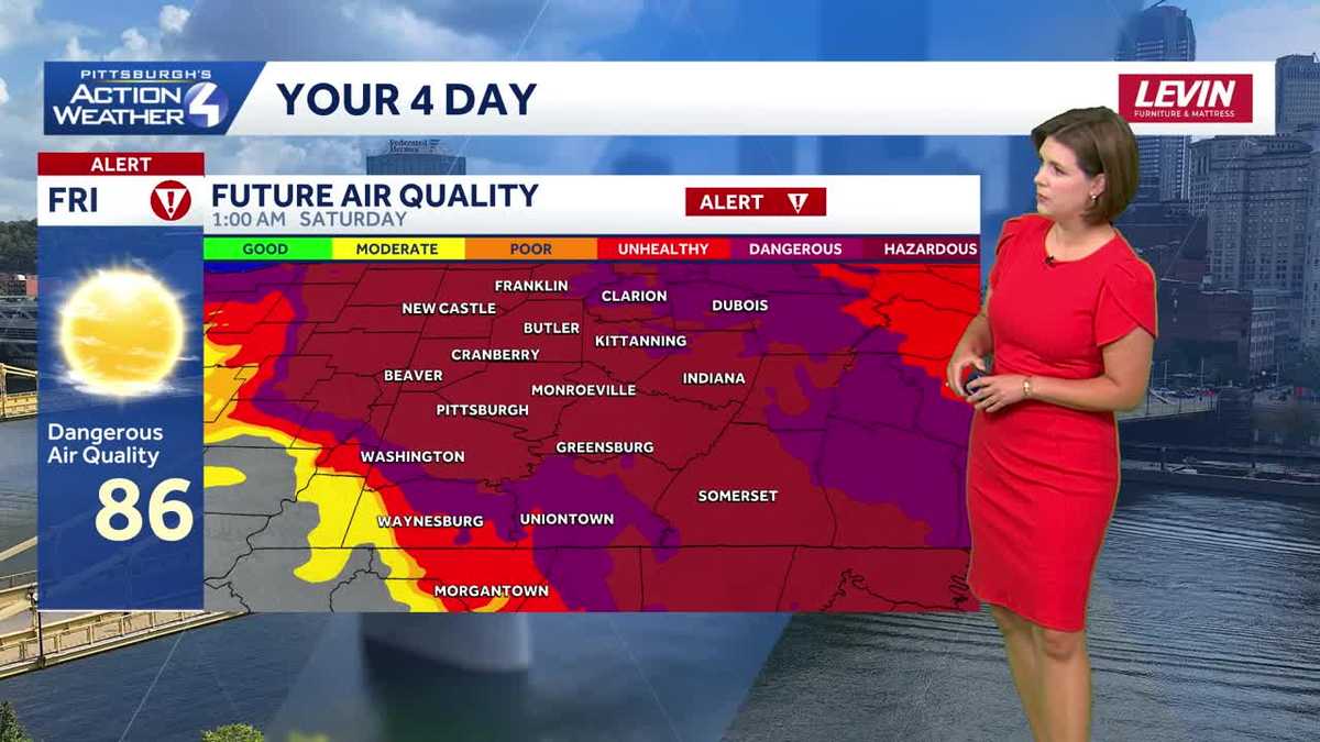
The next two days are Severe Weather Alert Days. Today for the heavy smoke from Canadian wildfires that continues to choke western Pennsylvania with poor visibility and dangerous air quality. A cold front will bring the potential for strong to severe storms Saturday afternoon and evening.Code Purple Air Quality Alert for PennsylvaniaPlumes of heavy smoke continue to hang over western PA. Today is a Severe Weather Alert Day for dangerous air quality. Due to the risk of increased smoke at the surface, the PA Department of Environmental Protection has issued a Code Purple Air Quality Alert Day for all of Pennsylvania. Air quality will not improve until early Saturday. The smoke situation will start improving overnight.Second Alert Day for severe storms SaturdayThe good news is the rain will help knock the smoke out of the air tomorrow. The bad news, there is also the potential for strong and severe thunderstorms with the front, prompting another Severe Weather Alert Day. Spotty showers will be off and on throughout the day. Activity could pop up as early tomorrow morning. Rain may be heavy at times, especially in any thunderstorms, with some locations potentially picking up close to inch of rain. We will watch for a severe threat after 3 p.m. through sunset as a line of storms move south across Lake Erie. Damaging wind and flooding are the primary concerns. Hail and tornadoes are a lower, but non-zero threat with this line.Looking ahead: Cooler next weekSunday is the pick day of the weekend with clearing skies and more comfortable humidity levels. Temperatures will drop below normal as we move into next week after another chance at rain on Tuesday.TODAY- Severe Weather Alert Day: Dangerous air quality, partly cloudy. High: 86°.TONIGHT: Increasing clouds with a stray shower by sunrise. Low: 70°.SATURDAY – Severe Weather Alert Day: Periods of heavy rain and thunderstorms with strong to severe storms in the afternoon and evening. High: 83°, low: 66°.SUNDAY: Clearing skies and seasonal. High: 81°, low: 60°.MONDAY: Partly cloudy and turning more humid. High: 85°, low: 68°.
PITTSBURGH —
The next two days are Severe Weather Alert Days. Today for the heavy smoke from Canadian wildfires that continues to choke western Pennsylvania with poor visibility and dangerous air quality. A cold front will bring the potential for strong to severe storms Saturday afternoon and evening.
Code Purple Air Quality Alert for Pennsylvania
Plumes of heavy smoke continue to hang over western PA. Today is a Severe Weather Alert Day for dangerous air quality.
Hearst OwnedHearst
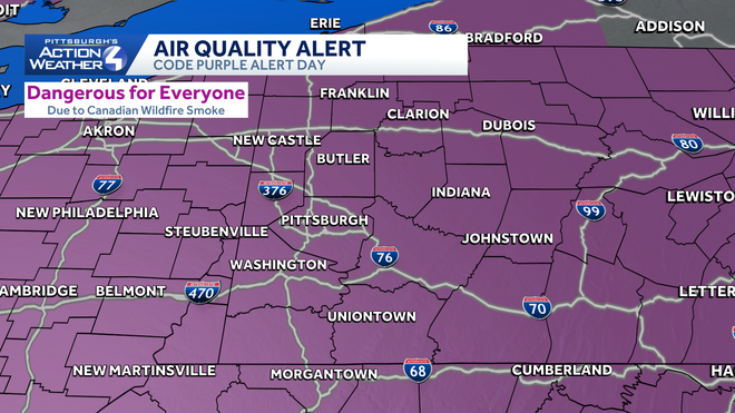
The entire state is under a Code Purple Alert for very unhealthy air quality.
Due to the risk of increased smoke at the surface, the PA Department of Environmental Protection has issued a Code Purple Air Quality Alert Day for all of Pennsylvania. Air quality will not improve until early Saturday. The smoke situation will start improving overnight.
Hearst OwnedHearst
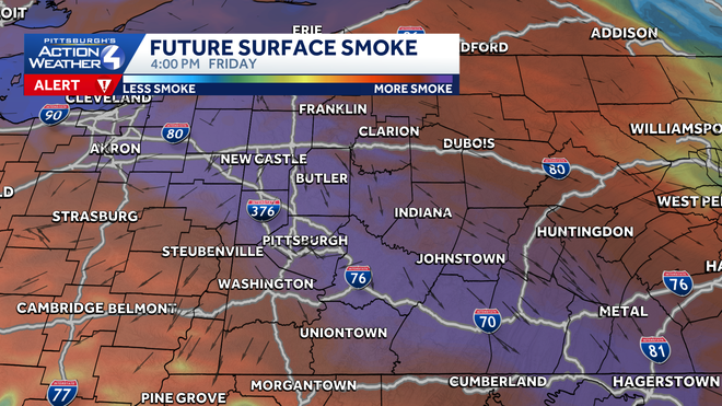
Thick wildfire smoke continues to hang over western Pennsylvania today.
Second Alert Day for severe storms Saturday
The good news is the rain will help knock the smoke out of the air tomorrow. The bad news, there is also the potential for strong and severe thunderstorms with the front, prompting another Severe Weather Alert Day.
Hearst OwnedHearst
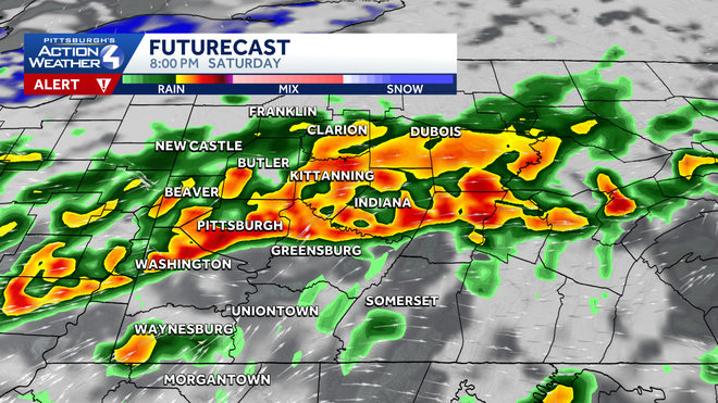
A line of potentially severe thunderstorms will drop southward Saturday afternoon and evening.
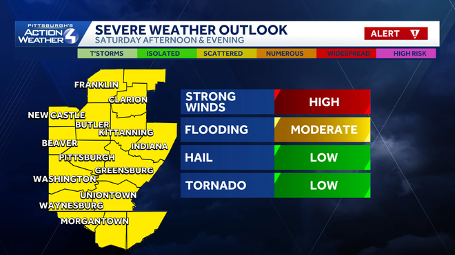
Spotty showers will be off and on throughout the day. Activity could pop up as early tomorrow morning. Rain may be heavy at times, especially in any thunderstorms, with some locations potentially picking up close to inch of rain. We will watch for a severe threat after 3 p.m. through sunset as a line of storms move south across Lake Erie. Damaging wind and flooding are the primary concerns. Hail and tornadoes are a lower, but non-zero threat with this line.
Hearst OwnedHearst
Damaging winds and flooding are the top storm threats late Saturday.
Looking ahead: Cooler next week
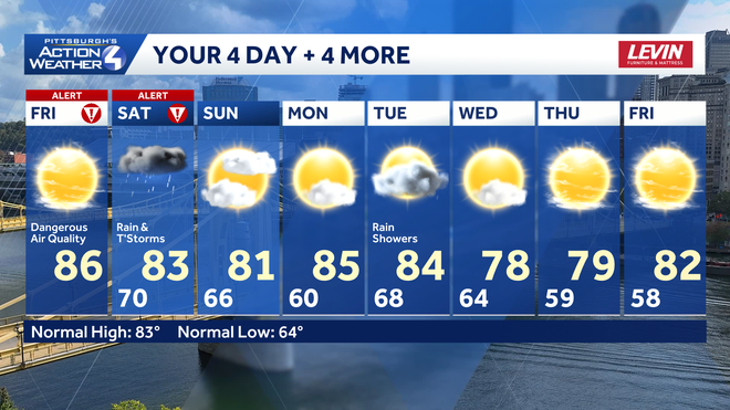
Sunday is the pick day of the weekend with clearing skies and more comfortable humidity levels. Temperatures will drop below normal as we move into next week after another chance at rain on Tuesday.
Hearst OwnedHearst
Sunday is the best day of the weekend. The summer heat gets toned down for the second half of next week.
TODAY- Severe Weather Alert Day: Dangerous air quality, partly cloudy. High: 86°.
TONIGHT: Increasing clouds with a stray shower by sunrise. Low: 70°.
SATURDAY – Severe Weather Alert Day: Periods of heavy rain and thunderstorms with strong to severe storms in the afternoon and evening. High: 83°, low: 66°.
SUNDAY: Clearing skies and seasonal. High: 81°, low: 60°.
MONDAY: Partly cloudy and turning more humid. High: 85°, low: 68°.