
After several days of poor air quality, severe weather is expected Saturday throughout the Lehigh Valley.
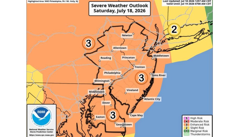
The National Weather Service is warning that the region is at a rare “enhanced” risk of severe weather breaking out throughout the day. Scattered thunderstorms are likely and could bring damaging wind, heavy rainfall that could lead to flash flooding, large hail, and even tornadoes.
Amanda Lee, a meteorologist with the weather service forecast office in Mount Holly, New Jersey, said that in the Lehigh Valley, the greatest risks will be posed by powerful gusts and flash flooding from heavy, fast rainfall.
The weather service puts the probability of the region having a severe wind gust of at least 58 mph at 45-59%.
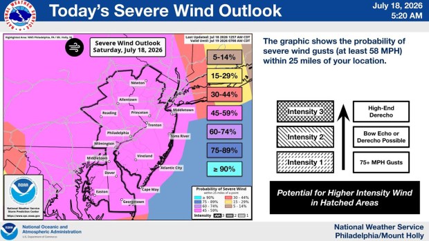 This map shows the severe wind outlook across eastern Pennsylvania for Saturday, July 18, 2026. (NWS)
More than two inches of rain total is possible, but there could be periods of extreme rainfall in a short period of time and 1 inch to 1.5 inches of rain falling within 30 minutes is not out of the question. Lee said instances like this would be when potential for flash flooding is the highest especially in urban areas. Taking reasonable precautions is advised.
“When thunder roars go indoors,” Lee said. “Anytime there’s a thunderstorm taking shelter is always a good idea.”
The region remains under a flood watch through 2 a.m. Sunday.
Tornadoes are also a possibility across the region. There is a 5-9% chance of a tornado forming in eastern Pennsylvania on Saturday, and the Lehigh Valley is within a region where a more powerful twister — up to an EF2 on the Enhanced Fujita scale — could form, according to the weather service.
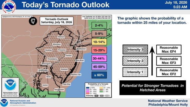 This map shows the tornado outlook for eastern Pennsylvania for Saturday, July 18, 2026. (NWS)
Temperatures will reach the low 80s Saturday and while winds will generally be mild, staying between 5 to 15 miles per hour most of the day, gusts as high as 30 miles per hour are possible. Chance of precipitation in 90%. Smoke is expected to persist until around noon when it will lessen due to wind direction changes.
The evening will be slightly cooler with temperatures in the high 60s. Western winds will average around 10 miles per hour with gusts possible. The risk of thunderstorms will persist until around 2 a.m. Sunday and chance of precipitation is 70%.
Sunday should be relatively warm and comfortable with thunderstorms possible once the workweek arrives. Here is the extended forecast:
Sunday: Sunny, with a high near 82. Northwest wind 10 to 15 mph.
Sunday Night: Mostly clear, with a low around 59. North wind around 5 mph.
Monday: Sunny, with a high near 82. Calm wind.
Monday Night: A chance of showers and thunderstorms after 2 a.m. Mostly cloudy, with a low around 67. Chance of precipitation is 30%. New rainfall amounts of less than a tenth of an inch, except higher amounts possible in thunderstorms.
Tuesday: A chance of showers, then showers likely and possibly a thunderstorm after 2 p.m. Cloudy, with a high near 79. Chance of precipitation is 70%.
Tuesday Night: Showers and possibly a thunderstorm before 2 a.m., then a chance of showers. Low around 69. Chance of precipitation is 80%.
Wednesday: A chance of showers, with thunderstorms also possible after 2 p.m. Partly sunny, with a high near 84. Chance of precipitation is 50%.
Wednesday Night: A chance of thunderstorms before 8 p.m. Partly cloudy, with a low around 62. Chance of precipitation is 30%.
Thursday: Sunny, with a high near 81.
Thursday Night: Mostly clear, with a low around 61.
Friday: Sunny, with a high near 84.