
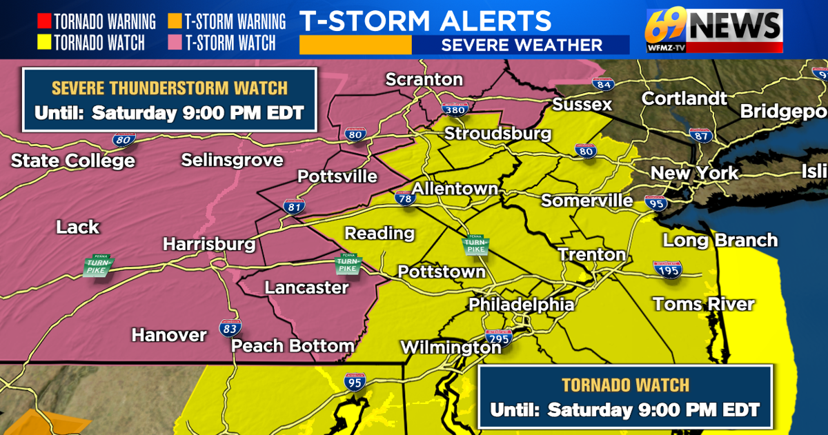
We’ve gone from intense heat to intense smoke and haze over this past week. And now the attention turns to the potential for intense thunderstorms as we go through the remainder of our Saturday.
That potential includes thunderstorms that can produce damaging wind gusts, hail, flooding downpours, and even a tornado or two. The Storm Prediction Center has our entire region highlighted under an “enhanced” threat for severe weather…a level 3 out of 5…and they have also now placed most of the region under a Tornado WATCH along with a Severe T-storm WATCH for our far northern and western counties of Pike, Luzerne, Schuylkill, Lebanon, and Lancaster. Both of these watches go until 9pm this evening.
Severe weather is not a guarantee area-wide, rather the ingredients will be in place for scattered strong to severe thunderstorms for the remainder of the afternoon into the evening. Initially, individual cells or clusters of storms will likely unfold. That should be followed by a line or multiple line segments by the evening as a cold front starts to cross the region.
Damaging straight-line winds are the main severe threat, with 60+mph wind gusts possible in any severe storms. Power outages and tree damage are possible in areas that experience the strongest wind gusts.
In addition to winds, there is a smaller but still real threat for some large hail of at least 1″ in diameter and a tornado or two. Thanks to strong winds aloft and a changing of wind direction with height…what we call wind shear in meteorology…this creates a bit of an elevated threat for tornadoes. A tornado up to the strength of an EF-2 (winds of 111-135mph) is even possible, but this threat should be fairly isolated.
And any thunderstorm, severe or not, can also produce frequent lightning and heavy downpours. A Flood WATCH is also in effect for much of the region through late Saturday night for the potential of 1 to 3 inches of rain. While many of us are still in a drought and need the rain, 1 to 3 inches of rain in an hour or two is too much rain too quickly, and can cause flash flooding. Smaller creeks and streams as well as urban locations and poor drainage areas will be the most susceptible to flooding.
So we’ll watch the skies closely for the potential of strong to severe thunderstorms for the rest of the day, and especially between 3pm and 9pm. Keep in mind these are approximate times and can change. Also, remember that some of the showers and storms we’ve already seen can directly impact how strong or weak the second round becomes. The longer cloudy skies and cooler temperatures linger in areas, the less of a threat there can be for storms to really gain strength. This is what we call a “cap” in meteorology…it’s like a lid that gets put on top of storm cells trying to grow and can keep severe weather at bay. If that “cap” breaks however and the sun comes out and temperatures really warm up, then there will be better odds to see some intense storms.
In addition to the severe threat, we’ll still have to contend with some leftover smoke from the most recent batch that peaked in terms of poorest air quality Thursday and Thursday night. What’s left of that batch will continue its journey north and east across the region eventually exiting for good by the evening. Multiple rounds of rain should finally improve air quality area-wide by this evening and for the remainder of the weekend. How thick the remaining smoke and haze are though can also impact thunderstorm development, yet another wild card in an already complex forecast. The thicker the smoke and haze are, the more you have the “cap” concept mentioned above in effect keeping storms from really gaining strength.
While it won’t rain all of the time, and not everyone will see severe weather, for the rest of the day you’ll want to stay weather aware. Be sure to listen to WFMZ-TV 69News, the 69News weather channel, and our 69News StormCenter App for your mobile device, which is free and provides the latest radars, watches and warnings, and forecasts.
TRACK THE WEATHER:
LINKS: HOUR BY HOUR | RADAR | TRAFFIC