
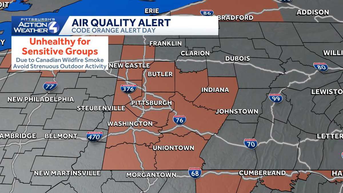
Code Orange Air Quality Alert issued for Southwestern Pa.
More smoke arrives and impacts air quality today.
Turning now to Pittsburgh’s action weather with the show to find most accurate forecast, meteorologist Jill Sweat, very quieter morning compared to yesterday, but that smoke is back. It’s like *** bit of *** merry go round to go into the smoke and then into the storms. We’ve got more of that over the next 3 days. Now the wildfire smoke today not as intense as it was late last week, but you’re probably starting to notice that milky look to the sky already this morning. There’s more to come as we work through your Sunday. Pretty nice July day tomorrow. That smoke will disperse that gears is up for our next. Weather alert day that is an upgrade for Tuesday as you could see *** more significant severe outbreak potentially across the region. Again, this is just an early look at what’s to come into the start of the week. Here’s the smoke though, for the most part it’s going to stay in the upper parts of the atmosphere. That’s good. It helps us breathe *** little bit easier but certainly impacts the appearance of the sky as we get closer to dinner time and certainly sunset. Some of that smoke is going to try and drift *** little bit closer to the surface, especially for areas north of the city of Pittsburgh. So that’s where you. You may find more of that campfire smell that unfortunately was with us through the end of last week. As you look through the day on Monday, *** lot of that smoke starts to disperse and things will improve as we go through the day. In your 4 day, plus 4 more forecast. The haze is back today, holds our temperatures to the upper 70s, lower 80s, getting *** little bit brighter for Monday. Tuesday again, our next severe weather alert day. This system could even stretch into Wednesday with just some lingering rain chances. It’s primarily late afternoon through about sundown on Tuesday. We could expect some of that severe weather behind that system. You’ll notice *** drop in temperature. We’re headed for the 70s with even low humidity and some sunshine. Now yesterday we were included in that numerous risk for severe weather, but some of those downpours early in the day cut back the area-wide threat. Already 3 days out, so it goes to show you how intense the setup could be on Tuesday. We are included in that orange area and this is area wide for Pittsburgh. All modes of severe. Weather are included, including those damaging winds and possibly even *** higher risk for tornadoes and flash flooding again. That’s the second half of Tuesday up out the door Tuesday morning. You may have *** dodge *** shower or two around lunchtime. Futurecast trying to paint some thunderstorms south of the city of Pittsburgh, but we’ll turn our attention on what’s coming in from the north and west with this potent system is going to pack *** lot of energy, *** lot of wind to all necessary. Ingredients for severe weather to fire when it comes together that really intensifies things again timing still going to be sorted out here over the next couple of days, but it looks to be late afternoon, including the evening commute and past sunset. We could be navigating some of that strong to severe weather and even some flash flooding concerns. You can see even with the clouds, *** little bit of the haze starting to mix into some sunshine tries to drift through visibility impacted the Pittsburgh International with the temperature of. 68, so *** gradual warm up today on our way to 79. We’ll ditch some of the clouds, but that haze, of course, becomes more prevalent throughout the day. Comfortable start to the day tomorrow, 57, 83 by the afternoon. Severe weather alert day Tuesday with severe weather through the second half of the day. Showers will wrap up early Wednesday. Then we look good for the rest of your day plus 4 more. Not only feeling good with sunshine, but also the temperatures will be nice and comfortable. All right, thanks.
Code Orange Air Quality Alert issued for Southwestern Pa.
More smoke arrives and impacts air quality today.

Updated: 11:28 AM EDT Jul 19, 2026
The latest plume of Canadian wildfire smoke arrives today. The Pennsylvania Department of Environmental Protection is issuing a Code Orange Air Quality Alert Sunday. Allegheny, Armstrong, Beaver, Butler, Fayette, Greene, Indiana, Lawrence, Mercer, Washington and Westmoreland counties are included in the alert. The air will be unhealthy for sensitive groups, including children, the elderly and people with underlying conditions. Limit or avoid strenuous outdoor activities.More: Get severe weather alerts for your countyInteractive radar: Track storms as they move through your areaLearn how to enable automatic weather alerts on the WTAE appThe smoke, which originated from fires in Canada, continues to impact much of the Great Lakes states. While not as intense across western PA, the light winds near the surface today along with the smoke that has already moved into the region will help to keep particulate matter levels elevated through the day. You are encouraged to keep a close eye on the AirNow website and app for the current status of air quality in your area. PA DEP will continue to monitor conditions through the day today and will update the forecast for tomorrow if conditions warrant.
PITTSBURGH —
The latest plume of Canadian wildfire smoke arrives today. The Pennsylvania Department of Environmental Protection is issuing a Code Orange Air Quality Alert Sunday.
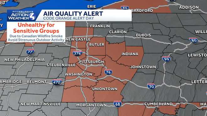
Hearst OwnedHearst
Children, the elderly and people with underlying conditions should limit or avoid strenuous outdoor activities.
Allegheny, Armstrong, Beaver, Butler, Fayette, Greene, Indiana, Lawrence, Mercer, Washington and Westmoreland counties are included in the alert. The air will be unhealthy for sensitive groups, including children, the elderly and people with underlying conditions. Limit or avoid strenuous outdoor activities.
The smoke, which originated from fires in Canada, continues to impact much of the Great Lakes states. While not as intense across western PA, the light winds near the surface today along with the smoke that has already moved into the region will help to keep particulate matter levels elevated through the day.
You are encouraged to keep a close eye on the AirNow website and app for the current status of air quality in your area.
PA DEP will continue to monitor conditions through the day today and will update the forecast for tomorrow if conditions warrant.