
(WBRE/WYOU) — As you wake up, you may see some areas of patchy fog due to clearing, lighter winds, and moisture from the rain that fell yesterday.
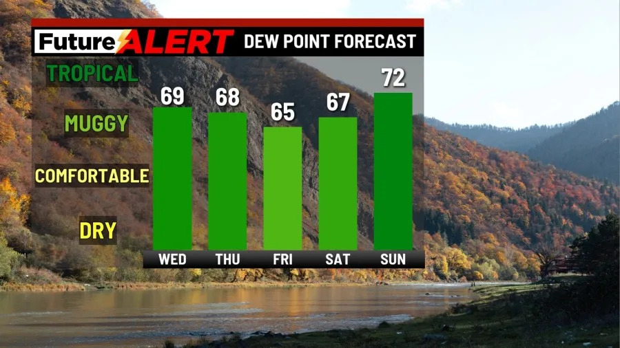
This fog should clear as winds begin to pick up, and it won’t linger long after sunrise. Our skies will be mostly cloudy, and today will feel quite muggy, with dew points in the mid-to-upper 60s. Expect highs to be in the mid-70s. Don’t rule out the chance for a few showers and storms today as well. Tonight, it will continue to be mostly cloudy, and scattered showers will stick around into the overnight hours.
Tomorrow will be mostly cloudy once again. Showers will linger, but as high pressure builds into the region, there will be less chance for a shower as the day goes on. It will be muggy tomorrow as well. Highs will be in the mid 70s. High pressure will remain in control on Friday. Skies will be partly sunny. There is the possibility for a stray shower, so keep that in mind. Saturday will also be partly sunny with a stray shower.
The second half of the weekend proves to be more uncertain. What we understand now is that Sunday will contain the highest chance for showers as moisture enters our region. It will be mostly cloudy with showers and thunderstorms possible. A front will move through from Sunday into Monday, keeping showers and storms around for the start of next week. Mostly cloudy skies will linger, too. Tuesday will also be mostly cloudy. We do believe there will be some possibility for showers and storms. We will update you as we get closer.
You can stay current on all the latest weather alerts and track the storm using the Future Alert Interactive Radar.
Copyright 2026 Nexstar Media, Inc. All rights reserved. This material may not be published, broadcast, rewritten, or redistributed.
For the latest news, weather, sports, and streaming video, head to 28/22 News.