
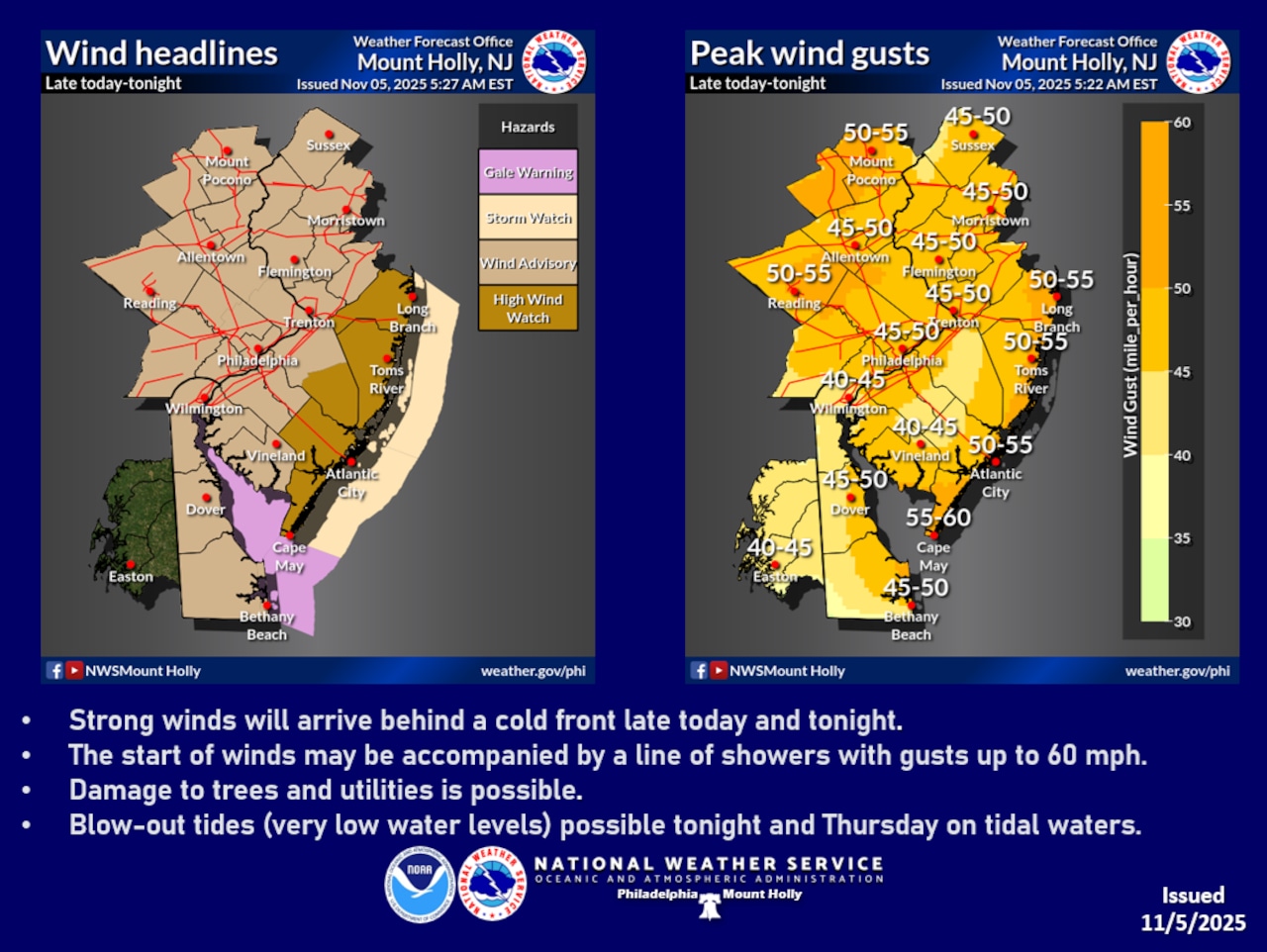
The National Weather Service issued a Wind Advisory for Lehigh, Northampton and Warren counties — in effect from 7 p.m. Wednesday to 7 a.m. Thursday, with potentially dangerous wind conditions anticipated across the region.
Residents should prepare for strong northwest winds that could produce gusts between 45 and 55 mph, creating potential hazards for outdoor objects and travel.
The wind event is associated with a cold front moving through the region overnight, creating a sharp pressure gradient that will drive intense wind speeds. The National Weather Service warns that winds aloft could reach up to 50 knots, with the potential to bring very strong wind gusts down to surface levels. The strongest winds are expected during the late evening and overnight hours, with conditions beginning to subside Thursday morning.
Temperatures will remain relatively mild before the wind event, reaching into the mid-60s during the day Wednesday. Sustained westerly winds are forecast around 10-15 mph during the day, increasing to 15-25 mph at night when the strongest gusts are expected.
After the cold front passes, temperatures will drop, with Thursday’s highs expected in the 50s. Predawn Friday morning, temperatures are forecast to dip below freezing across the Lehigh Valley region and the Poconos. Northwest winds are expected to become calm by Thursday night into Friday.
The extended forecast indicates a series of weather systems moving through the region. After a mostly cloudy Friday with highs approaching 60 degrees, rain is likely overnight Friday into Saturday before skies clear and temperatures rise into the mid-60s.
There are more chances of rain overnight Saturday into Sunday and throughout the day Sunday across the Lehigh Valley region, with potentially stormy conditions continuing into Monday.
Temperatures are expected to cool significantly early next week, with highs potentially dropping into the 40s and overnight lows near or below freezing, which could signal the end of the growing season.
Residents are advised to secure loose outdoor items, be prepared for potential power interruptions, and monitor local weather updates for the most current information about wind and weather conditions.
Follow your local forecast from AccuWeather at lehighvalleylive.com/weather with National Weather Service watches, warnings and other advisories available as they’re issued at lehighvalleylive.com/weather-alerts.
Current weather radar
Generative AI was used to produce an initial draft of this story, which was reviewed and edited by lehighvalleylive.com staff.
If you purchase a product or register for an account through a link on our site, we may receive compensation. By using this site, you consent to our User Agreement and agree that your clicks, interactions, and personal information may be collected, recorded, and/or stored by us and social media and other third-party partners in accordance with our Privacy Policy.