
It looks like the region might be heading into a heat wave the next several days with high temperatures forecast to reach 90 or higher beginning Thursday for many areas in the southeastern Pennsylvania and New Jersey region. But it won’t push the thermometer to triple digits like the beginning of July.
The National Weather Service Mount Holly office issued a heat advisory in effect from 10 a.m. Thursday to 8 p.m. Friday. It forecast an elevated to significant risk for extreme heat on Friday for most of the Philly region of southeastern Pennsylvania and New Jersey.
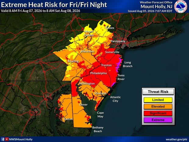 The National Weather Service prediction map issued Aug. 5, 2026 shows extreme and significant heat risk for much of the southeastern Pennsylvania and New Jersey region for Friday, Aug. 7, 2026. (Courtesy of National Weather Service)
Alan Reppert, a senior meteorologist with AccuWeather in State College, said showers and thunderstorms are expected to move through the area Wednesday night, and there will be a risk of heavy downpours and thunderstorms through Saturday that may hinder the region from registering an official heat wave.
A heat wave is defined as three or more consecutive days where the high temperature reaches at least 90 degrees.
Reppert said the showers and storms moving through the area the next several days are likely to put a lid on temperatures but the dewpoints will soar. That means sticky, humid days.
The NWS is calling for a 70% chance of rain Thursday in Berks, Carbon, Lehigh, Northampton counties in Pa. and Mercer County, N.J. There is a 40% to 50% chance of rain Thursday in Bucks, Chester, Delaware, Montgomery, Philadelphia counties in Pa. and 30% in Camden and Hunterdon counties in N.J.
High temperatures are expected to be in the high 80s to around 90 Thursday, Friday, Saturday and Sunday for the region.
NWS forecast
Thursday: A chance of showers and thunderstorms after 2 p.m. Partly sunny, with a high near 91. Heat index values as high as 103. Calm wind becoming southwest around 5 mph in the afternoon. Chance of precipitation is 30%. New rainfall amounts of less than a tenth of an inch, except higher amounts possible in thunderstorms.
Thursday night: A chance of showers and thunderstorms, mainly before 1 a.m. Mostly cloudy, with a low around 71. Southwest wind around 5 mph becoming calm in the evening. Chance of precipitation is 50%. New rainfall amounts between a tenth and quarter of an inch, except higher amounts possible in thunderstorms.
Friday: Showers and possibly a thunderstorm after 2 p.m. High near 90. Calm wind becoming southwest around 5 mph in the afternoon. Chance of precipitation is 80%. New rainfall amounts between a tenth and quarter of an inch, except higher amounts possible in thunderstorms.
Friday night: Showers and thunderstorms before 11 p.m., then a chance of showers between 11 p.m. and 2 a.m. Low around 70. Chance of precipitation is 80%. New precipitation amounts between a tenth and quarter of an inch, except higher amounts possible in thunderstorms.
Saturday: A chance of showers and thunderstorms after 2pm. Mostly sunny, with a high near 89. Chance of precipitation is 40%.
Saturday night: A chance of showers and thunderstorms before 8pm. Partly cloudy, with a low around 70. Chance of precipitation is 30%.
Sunday: Sunny, with a high near 89.
Sunday night: Mostly clear, with a low around 68.
Monday: Mostly sunny, with a high near 90.