
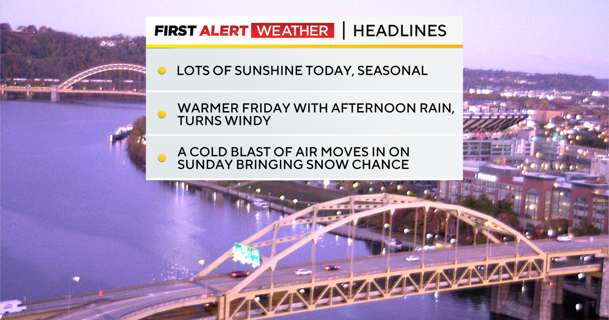
The area’s first widespread snow event is expected to occur Sunday into Monday. An elongated trough and associated upper low that is anchored over the southern part of Hudson Bay will push a strong jet streak over western Pennsylvania.
WEATHER LINKS:
Current Conditions | School Closings & Delays | Submit Your Weather Photos
We will see two mid-level lows, sometimes called Alberta Clippers, that will quickly slide by over the weekend. The first of these mid-level lows will occur on Friday.
The second mid-level low will move by on Sunday into Monday and will bring the area’s first widespread snow event of the season. While you won’t be needing to shovel any driveways, you will be impacted by Sunday night’s snow, with the potential for slick spots on roads, slowing traffic

Precipitation chances over the next six days
KDKA Weather Center
Let’s start with today’s weather, which will be seasonal with highs in the mid to low 50s. Morning lows bottomed out in the mid to low 30s. Skies will be sunny for most of the day, including all morning long. We will see some high clouds move in after 3 this afternoon, and clouds will only thicken in the overnight hours.
I have wind speeds of 7-15mph coming in out of the west.
Friday will also start off dry with rain chances returning as we head into the afternoon. Data this morning is a little faster with Friday’s rain, having the peak rain chance in Pittsburgh happening from 2 p.m. to 6 p.m. Wind speeds will pick up behind the rain with gusts of up to 35mph once again possible.

Forecast for the Pittsburgh area – November 6, 2025
KDKA Weather Center
Rain starts off early on Sunday with isolated to scattered showers expected to arrive before 8 a.m. and continuing for the rest of the morning into the afternoon. One of the things that I knew needed to be cleaned up was when exactly we would begin to see the change from all rain to a wintry mix of rain, sleet, and snow.
Model data is showing a more believable time of around 8 p.m. before the changeover begins, with us seeing mostly snow by 11 p.m. on Sunday. Snow totals (what falls) will be more than you are expecting.
I have Pittsburgh’s snow total (what falls) as around an inch. What sticks?
Little to nothing, and unless you are in higher elevations, don’t expect to see more than a dusting briefly down on the ground. Nothing should make it more than around 5 minutes on the ground in Pittsburgh.
The Monday morning issue will be that with rapidly falling temperatures and a steady wind out of the northwest, we could potentially see a number of slick spots slowing down traffic on Monday.

7-day forecast: November 6, 2025
KDKA Weather Center
Stay up to date with the KDKA Mobile App – which you can download here!
More from CBS News