
An arctic blast of cold air is headed to the Northeast this weekend and into early next week, bringing the coldest air of the season and a possible first snow to some areas, including Pennsylvania, according to meteorologists. Here’s what to know about the cold wave and when to expect the first snowfall of the season.
Meteorologist Ryan Maue described the upcoming cold wave as a “stunning arctic blast to wallop Eastern U.S. this weekend and early next week.” He added, “A pool of extremely cold air in the middle atmosphere will dump into the Great Lakes and Ohio River Valley” and compared it to temperatures more typical of mid-January rather than early November.
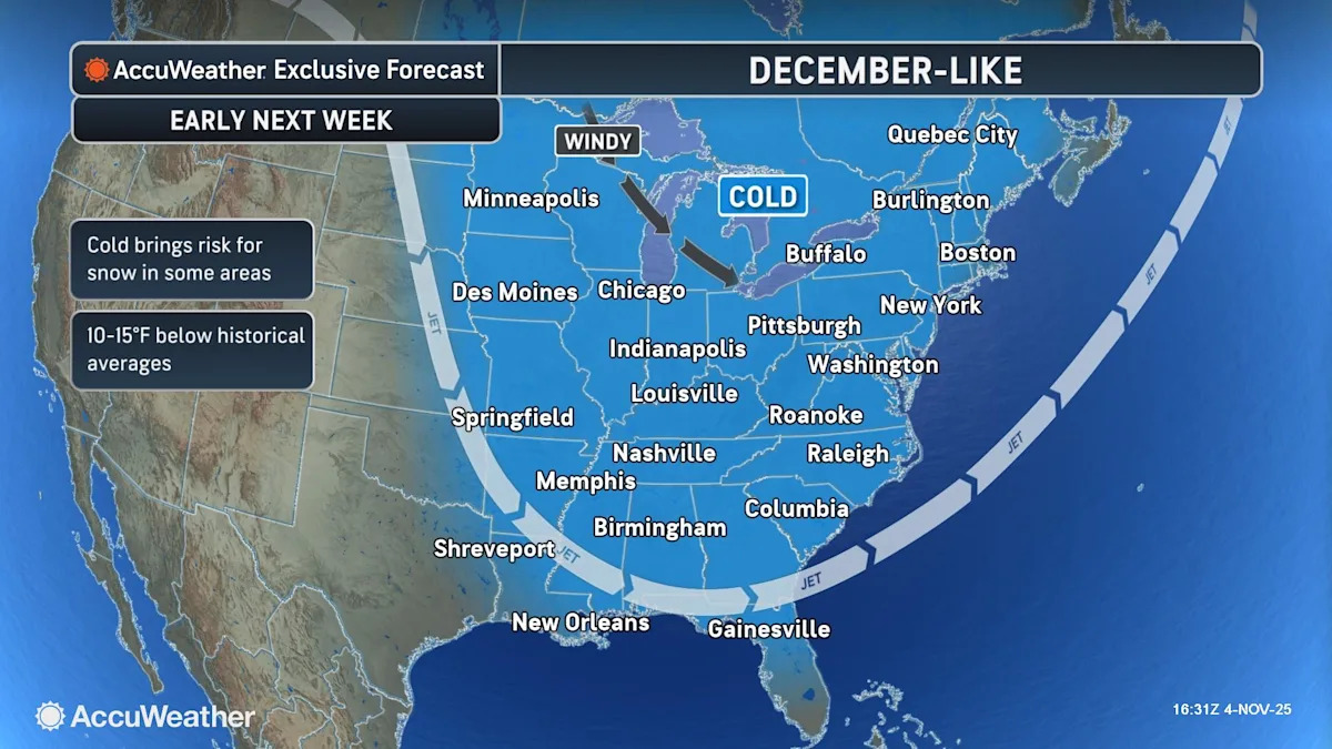
“Temperatures will feel more like mid-December or even Christmastime in many places by next week,” AccuWeather Lead Long-Range Meteorologist Paul Pastelok said. Adding, “Blustery winds will intensify the coming cold with the need for winter attire.”
Starting this weekend, a significant dip in the jet stream is forecast make it feel like winter for the Eastern and Central states, according to AccuWeather, bringing a “dramatic temperature drop and blustery winds” that will carry into early next week with a potential for accumulating snow in some areas, including the Appalachians and parts of the Great Lakes.
The potent cold front will push across the state Sunday afternoon and night with a period of showers and isolated thunderstorms, followed by the coldest air of the season so far for Monday and Tuesday, when temperatures will drop to 30’s and 40’s for highs and drop into the 20’s for the lows, according the National Weather Service. “These temps will support flurries/brief snow showers even across the Central Ridge and Valley region of the state.”
The cold wave and associated weather hazards are expected to improve by midweek, with milder air next week across the Northeast. However, meteorologists predict another storm may bring additional snow chances to the Great Lakes and interior Northeast between Wednesday and Thursday.
Typically, the first measurable snowfall in the Northeast region has come as early as late September for areas of Vermont and Maine in prior years, while Erie, Pennsylvania has gotten it as early as the first week of October, according to the Northeast Regional Climate Center, with an overall average date for most areas ranging from October to late December.
Erie, PA – Nov. 9 is the average date of first measurable snow
Pittsburgh, PA – Nov. 16 is the average date of first measurable snow
Allentown, PA – Dec. 6 is the average date of first measurable snow
Kennedy Airport, NY – Dec. 9 is the average date of first measurable snow
Newark, NJ – Dec. 9 is the average date of first measurable snow
Willmington, DE – Dec. 17 is the average date of first measurable snow
Philadelphia, PA – Dec. 19 is the average date of first measurable snow
Here’s how much snow is predicted for 2025-26 and what The Old Farmer’s Almanac says about the Thanksgiving forecast and the Pennsylvania’s winter weather.
What is a cold wave?
A cold wave is characterized by a rapid and sharp drop in air temperature over a large area within 24 hours and extreme low temperatures for at least two consecutive days or more during the cold season.
How much snow will Pennsylvania get in 2025-26?
Precipitation and snowfall is expected to be below normal for the upcoming 2025-26 winter season in Pennsylvnina, according to the Old Farmer’s Almanac. Though, the Pittsburgh area may be an outlier where more snow is predicted.
Average snowfall totals in Pennsylvania can vary from as little as 18-24″ in areas like Philadelphia to 36-42″ in the Poconos to as much as 110-140″ in areas surrounding Erie, according to PAWeatherAction.com.
Last year’s snow totals, according to the National Weather Service for 2024-2025, showed Erie with a high 109.9″, Pittsburgh with 30.4″, Wilkes-Barre/Scranton with 27.8″, Allentown with 17.8″ and Philadelphia with 8.1.”
Old Farmer’s Almanac Thanksgiving 2025 forecast
The Old Farmer’s Almanac calls for “sunshine in much of the East” and rainy in the West with some snow limited to a few states on the Northern tier of the country, including New England and the Upper Midwest.
Pennsylvania and the Northeast region are forecast for colder than average temperatures to accompany the sunny sky forecast over the holiday, but according to The Old Farmer’s Almanac there may be some light snow through the Great Lakes and Ohio Valley prior to Turkey Day.
Neighboring New Jersey, Delaware, and the Atlantic Corridor is forecast to see “temperatures slip from mild early to chilly by the holiday, but skies stay bright and dry” according to the Old Farmer’s Almanac. Pleasant travel conditions without rain or snow delays are predicted.
What is the Old Farmer’s Almanac winter weather forecast for 2025/26?
The Old Farmer’s Almanac winter weather forecast 2025-2026 calls for “mostly mild – with pockets of wild.” But for most of Pennsylvania, that forecast says “Colder than usual with a split snow story: lighter in the north, heavier in the south.”
Temperatures are predicted to be below normal with the coldest spells coming in mid- and late-December, early and late-January and early February.
Precipitation is forecast to be below normal, translating to below normal snowfall. The most snow is expected to arrive in late-December, late-January, early and late-February, and mid-March, according to the Old Farmer’s Almanac.
When is winter solstice 2025?
Winter solstice 2025, which marks the start of winter in the Northern Hemisphere, will occur on Sunday, Dec. 21, 2025, 10:03 a.m. Eastern.
How accurate is the Old Farmer’s Almanac?
Weather predictions are accurate about 80% of the time, according to the Old Farmer’s Almanac website, citing inaccuracies can be reflections of abnormal weather patterns.
Maria Francis is a Pennsylvania-based journalist with the Mid-Atlantic Connect Team
This article originally appeared on Erie Times-News: Cold air front, first snow for Pennsylvania on winter weather forecast