
Some parts of western Pennsylvania could see their first round of accumulating snowfall this season in the coming days. A strong area of low pressure moving in from the northwest, generally referred to as a clipper system brings in areas of rain showers to the region Sunday. In this system’s wake Monday, some of the coldest air we’ve seen so far this season moves into Pennsylvania Sunday night into Monday.A strong upper-level trough, or simply a big dip in the jet stream, will allow colder Canadian air to move over the relatively warmer Great Lakes waters. Accumulating snowfall is likely across the northwestern portion of Pennsylvania and into the Laurel Highlands.At this time, snow accumulation is not likely in the Susquehanna Valley, but some flakes mixing in with some rain showers are possible Monday evening and early Monday night. Ground temperatures, at this time, look to be too warm for accumulation. That is a different story out west towards Pittsburgh and towards Erie. This is about the right time of the year for western Pennsylvania residents see their first snowfall. According to the National Weather Service, Cleveland, Ohio branch, Erie sees its first accumulating snow, that means at least 0.1″ of snow or more, on average around November 6. According to the National Weather Service, Pittsburgh, Pennsylvania branch and NOAA Regional Climate Data Center, Pittsburgh sees their first snowfall on average around November 16 when looking at the average between 1990 and 2020, the current 30-year average period meteorologists use. The average first measurable snowfall for us here in the Susquehanna Valley typically comes later. The long-term average first measurable snowfall in Harrisburg is December 1.
Some parts of western Pennsylvania could see their first round of accumulating snowfall this season in the coming days.
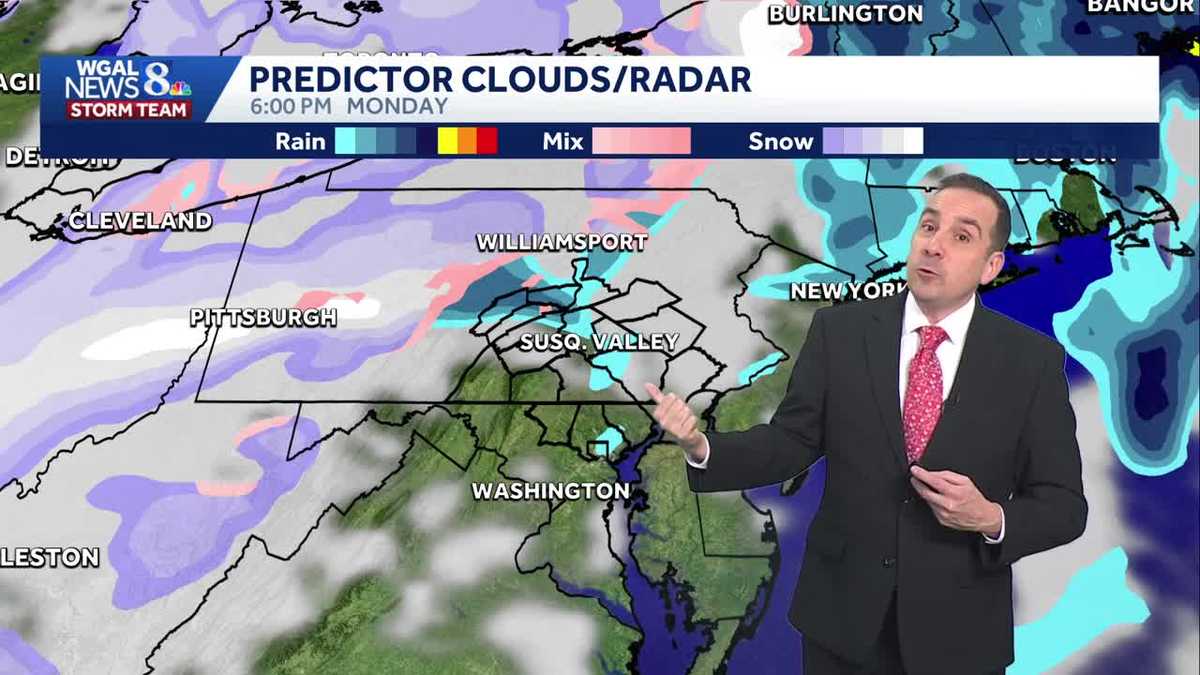
A strong area of low pressure moving in from the northwest, generally referred to as a clipper system brings in areas of rain showers to the region Sunday. In this system’s wake Monday, some of the coldest air we’ve seen so far this season moves into Pennsylvania Sunday night into Monday.

Hearst OwnedWGAL
Predictor for Monday Evening
A strong upper-level trough, or simply a big dip in the jet stream, will allow colder Canadian air to move over the relatively warmer Great Lakes waters. Accumulating snowfall is likely across the northwestern portion of Pennsylvania and into the Laurel Highlands.

Hearst OwnedWGAL TV
Predictor Snowfall Monday Evening
At this time, snow accumulation is not likely in the Susquehanna Valley, but some flakes mixing in with some rain showers are possible Monday evening and early Monday night. Ground temperatures, at this time, look to be too warm for accumulation.
That is a different story out west towards Pittsburgh and towards Erie.
This is about the right time of the year for western Pennsylvania residents see their first snowfall.
According to the National Weather Service, Cleveland, Ohio branch, Erie sees its first accumulating snow, that means at least 0.1″ of snow or more, on average around November 6.

Source: National Weather Service
Yearly Snowfall Erie
According to the National Weather Service, Pittsburgh, Pennsylvania branch and NOAA Regional Climate Data Center, Pittsburgh sees their first snowfall on average around November 16 when looking at the average between 1990 and 2020, the current 30-year average period meteorologists use.

Source: National Weather Service, NOAA
First Snowfall Average Pittsburgh
The average first measurable snowfall for us here in the Susquehanna Valley typically comes later. The long-term average first measurable snowfall in Harrisburg is December 1.

Hearst OwnedWGAL
Average First Snowfall Harrisburg