
Could it be? Yes, snowflakes are in the forecast for the first time this season for the end of the weekend and the start of next week.Western Pennsylvania’s winter weather outlook: Frequent snow and mixed precipitation this winter seasonThe first cold shot of the season arrives on the heels of Sunday’s Impact Day for scattered rain showers. Temperatures will plummet Sunday evening. It will get cold enough to see a transition from rain to snow. The flakes will continue to fly Monday. A fresh batch is also possible on Tuesday, mainly for areas north of Pittsburgh.Your next question probably is: Will the snow stick? For the most part, the answer is no. The ground is still quite warm. Most of the snowflakes will melt on contact. However, the falling snow plus breezy conditions could impact visibility on Monday.A skiff, or light brush of snow, is possible on mulch beds, the grass and some rooftops to the north as Monday unfolds. Registering the first measurable snow of the season could be a little harder to come by at the official observation site in Pittsburgh. Pittsburgh averages the first measurable snow of the season – an accumulation of 0.1″ or greater – on Nov. 14. In the past five years, the first flakes of the season have been spotted in the first two weeks of November. (Last year was a little later. We waited until Nov. 21.)These flakes arrive with the coldest air of the season. Daytime temperatures for Monday and Veterans Day will be in the 30s to around 40 degrees. Wind chills will be a factor in the morning with readings in the teens.
PITTSBURGH —
Could it be? Yes, snowflakes are in the forecast for the first time this season for the end of the weekend and the start of next week.
Western Pennsylvania’s winter weather outlook: Frequent snow and mixed precipitation this winter season
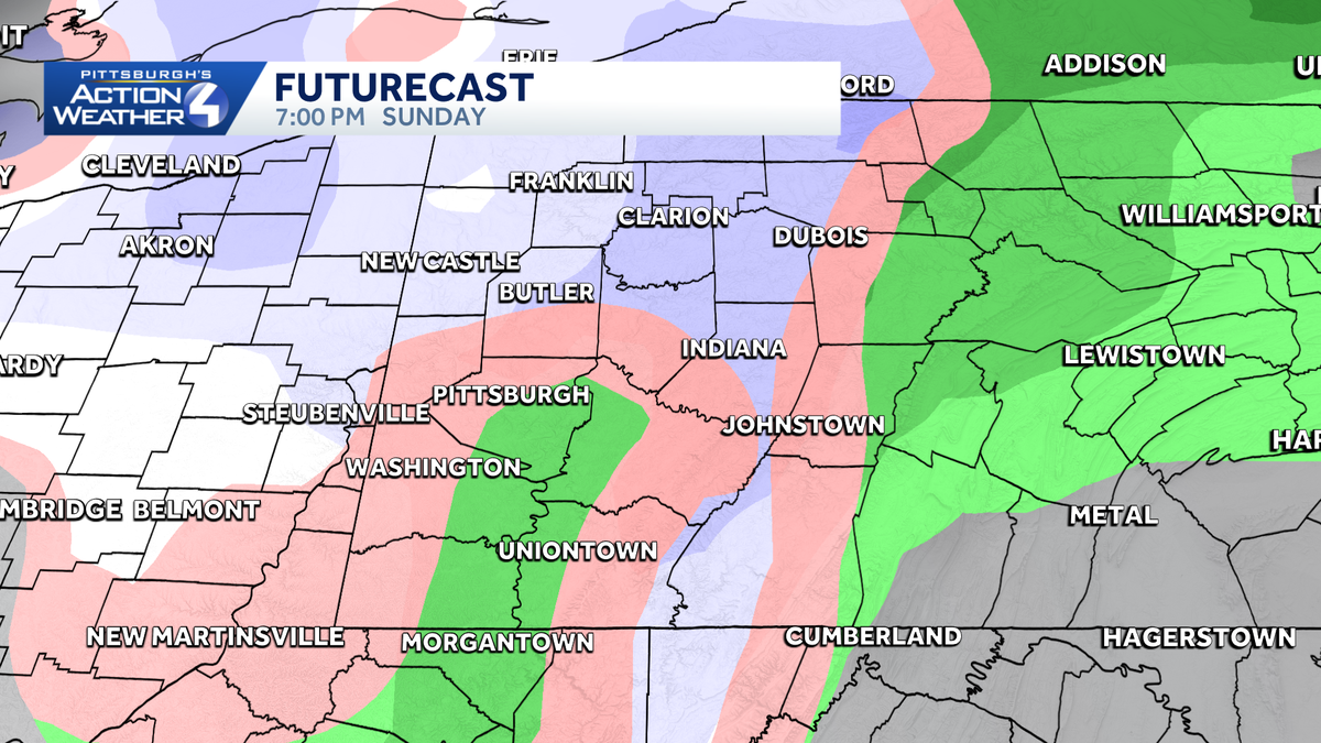
The first cold shot of the season arrives on the heels of Sunday’s Impact Day for scattered rain showers. Temperatures will plummet Sunday evening. It will get cold enough to see a transition from rain to snow. The flakes will continue to fly Monday. A fresh batch is also possible on Tuesday, mainly for areas north of Pittsburgh.

Hearst Owned
Rain will transition to snowflakes Sunday evening.
Your next question probably is: Will the snow stick? For the most part, the answer is no. The ground is still quite warm. Most of the snowflakes will melt on contact. However, the falling snow plus breezy conditions could impact visibility on Monday.

Hearst Owned
As flurries fly, the ground and air will be too warm for much of it to stick.
A skiff, or light brush of snow, is possible on mulch beds, the grass and some rooftops to the north as Monday unfolds. Registering the first measurable snow of the season could be a little harder to come by at the official observation site in Pittsburgh.
Pittsburgh averages the first measurable snow of the season – an accumulation of 0.1″ or greater – on Nov. 14. In the past five years, the first flakes of the season have been spotted in the first two weeks of November. (Last year was a little later. We waited until Nov. 21.)

Hearst Owned
The average first snow in Pittsburgh is November 14. Monday is November 10.
These flakes arrive with the coldest air of the season. Daytime temperatures for Monday and Veterans Day will be in the 30s to around 40 degrees. Wind chills will be a factor in the morning with readings in the teens.