
It’s another foggy start to our morning.
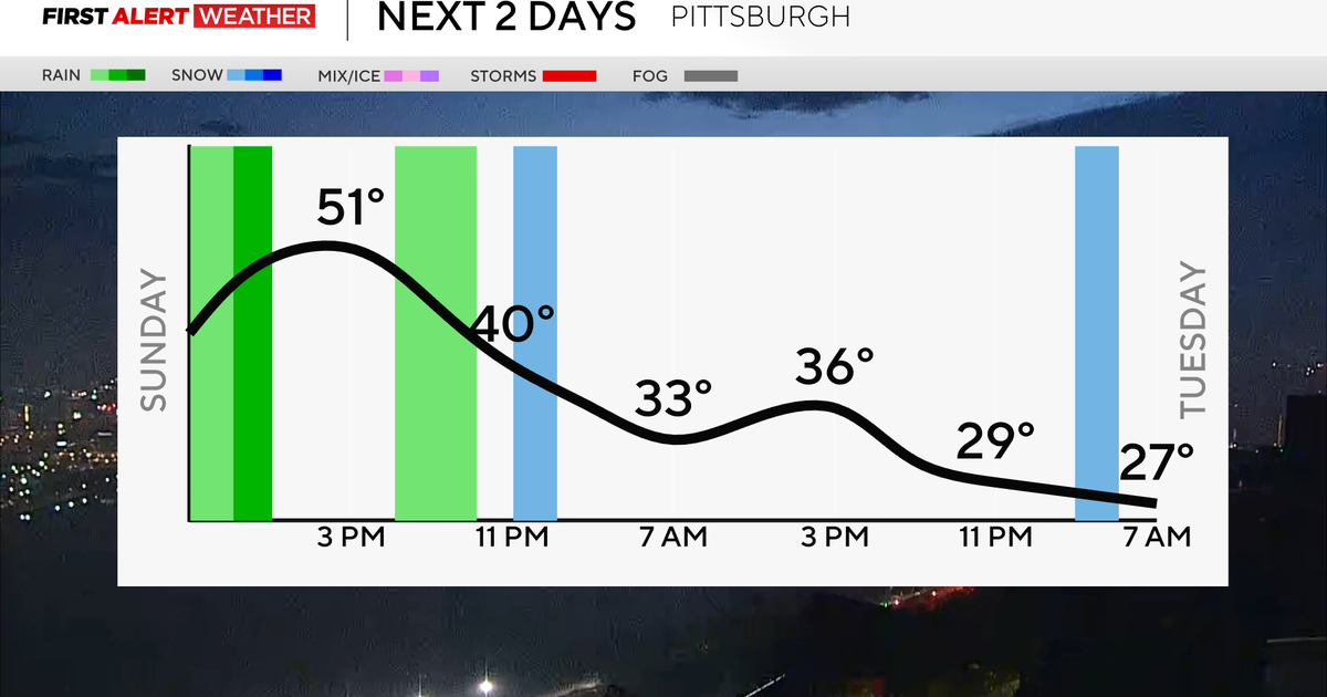
A round of rain already moved through the north this morning, and more is on the way. A strong cold front will cross the region in the afternoon, bringing a quick round of heavy rain with temperatures around 50.
WEATHER LINKS:
Current Conditions | School Closings & Delays | Submit Your Weather Photos
After that, our temperatures will fall quickly, leaving us in the upper 30s in the early evening, and rain will switch to a wintry mix.

Hourly temperatures over the next two days
KDKA Weather Center
A lot of this will melt, but could accumulate in the grassy surfaces, especially for areas north and higher elevations east. Icy bridges and overpasses will be a big concern as our lows Monday and Tuesday dip into the 20s, and strong wind gusts of 20-30mph will make it feel even colder.

Wind gusts throughout the day
KDKA Weather Center
Tuesday will be the coldest morning with wind chills in the teens and possibly even single digits for areas in the Laurel Highlands.

Feels-like temperatures early on Tuesday morning
KDKA Weather Center
As of 7 a.m. on Sunday, there are no watches or warnings for us, but 2-4″ is expected north of I-80 and in the Laurel Highlands and parts of northwestern Maryland and West Virginia.

Expected snow through Tuesday evening
KDKA Weather Center
Areas north of 422 could pick up 1-2″ from Monday to Tuesday evening, and then a trace to an inch for the Pittsburgh surrounding areas. It’ll be different for everyone, especially with different temperatures and lake effect snow bands and squalls expected.
Wednesday and through the start of the weekend, it’ll be quiet with some sunshine and highs back in the low 50s!
Above normal temperatures are set to move in through mid-November.

7-day forecast: November 9, 2025
KDKA Weather Center
Stay up to date with the KDKA Mobile App – which you can download here!