
IMPACT DAYS | Coldest air of the season hits Pennsylvania with frigid wind chills
Pennsylvania braces for the coldest air of the season as a storm system brings frigid temperatures and strong winds, making Monday and Tuesday Impact Days.
LET’S TALK ALL ABOUT THE FEELS LIKE TEMPERATURES, BECAUSE THIS IS GOING TO BE THE TALKER TODAY, TONIGHT, TOMORROW, AS WE GET OUR FIRST COLD SNAP OF THE SEASON. RIGHT NOW, WIND CHILLS IN SOME SPOTS ARE IN THE 30S, BUT THEY’RE GOING TO CONSISTENTLY BE IN THE 30S THIS AFTERNOON. HERE WE ARE AT LUNCHTIME AND THROUGH EARLY EVENING. NOW BY MID EVENING THESE WIND CHILLS THEY WILL DIP INTO THE 20S AND CONTINUE TO FALL OVERNIGHT. SO BY THIS TIME TOMORROW MORNING WE COULD HAVE SOME WIND CHILLS IN THE TEENS IN THE SUSQUEHANNA VALLEY. AND THEY DON’T IMPROVE TOO MUCH IN THE AFTERNOON, ONLY TO THE LOW 30S. SO CERTAINLY SOME IMPACTFUL COLD WEATHER HEADED OUR WAY FOR MONDAY AND TUESDAY. CHILLS WILL BE IN THE 30S MOST OF THE DAY TODAY, TOMORROW. STILL BLUSTERY, EVEN STRONGER WINDS. SO IT’S GOING TO FEEL LIKE THE 20S AND 30S MOST OF THE DAY. BUT HIGHS DO REBOUND TO THE LOW 50S BY WEDNESDAY. TODAY, OUR NEWS EIGHT STORM TEAM FORECAST CALLS FOR TEMPERATURES 42 TO 46. WE ALREADY HIT OUR HIGH OF 50 AT MIDNIGHT. NOW, THAT MAY NOT SEEM THAT BAD, BUT IT’S GOING TO BE CHILLY THIS AFTERNOON WHEN WE DON’T GET OUT OF THE 30S FOR WIND CHILLS. TONIGHT, IMPACTS CONTINUE BECAUSE LOWS WILL DIP INTO THE 20S TO NEAR 30, BUT WIND CHILLS IN SOME SPOTS COULD BE IN THE UPPER TEENS AS KIDS WAIT FOR THE BUS TOMORROW MORNING. TOMORROW AFTERNOON, WE’LL RECOVER TO THE LOW 40S. AVERAGE HIGH IS 56 FOR THIS TIME OF THE YEAR, BUT WIND CHILLS, 20S AND 30S MOST OF THE DAY TOMORROW. HERE’S A LOOK BACK AT YESTERDAY. 56 WAS OUR HIGH AVERAGES 57 NOW ONLY THREE HUNDREDTHS OF AN INCH OF RAIN FELL IN HARRISBURG, BUT SOME SPOTS, ESPECIALLY SOUTHEASTERN COUNTIES, GOT CLOSE TO AN INCH OF RAIN. BY THE TIME IT WAS ALL SAID AND DONE, YOU HAD A ROUND IN THE MORNING AND AROUND LATER IN THE EVENING. TEMPERATURES RIGHT NOW THEY’RE IN THE 40S ON THEIR WAY DOWN. WINDS ARE PICKING UP BEHIND THIS FRONT TO ABOUT 10 TO 20MPH OUT OF THE NORTHWEST. SO WE’RE DONE WITH THE SHOWERS. WON’T RULE OUT A SPRINKLE OR A FLURRY, BUT AGAIN, THE BIG TALKER IS GOING TO BE THE WIND AND THE CHILLY TEMPERATURES. SPEAKING OF THE CHILL, LOOK AT THAT. THOSE ARE FREEZE WARNINGS ALL THE WAY DOWN TO THE DEEP SOUTH AND SNOW BACK IN THE MIDWEST. FOR US TODAY, I THINK THE CLOUDS HANG TOUGH. WE’LL SEE MOSTLY CLOUDY SKIES, HIGHS IN THE 40S, CHILLS IN THE 30S. TONIGHT WE CLEAR OUT AND THAT WILL ALLOW TEMPERATURES TO DROP IN SOME SPOTS IN THE UPPER 20S. SO THOSE WIND CHILLS COULD VERY WELL BE IN THE UPPER TEENS TOMORROW MORNING. TOMORROW AFTERNOON MAYBE A PASSING SNOW SHOWER NORTH OF THE TURNPIKE OR A FEW FLURRIES. BUT AGAIN, THE BIG STORY IS GOING TO BE THAT WIND AND THE CHILL, THE CHILL FINALLY LIFTS OUT ON WEDNESDAY. WE’LL SEE A MIX OF CLOUDS AND SUNSHINE. IT’S STILL BREEZY, BUT TEMPERATURES DO REBOUND BACK TO THE 50S. SO 52 DEGREES ON WEDNESDAY, 52 ON THURSDAY. WE’LL GO 54. FRIDAY. FAIRLY UNEVENTFUL THERE AT THE END OF THE WEEK WEATHER WISE. SATURDAY IS DRY. SUNDAY MAY FEATURE A SPRINKLE. KEEP AN EYE ON IT, BUT A BETTER CHANCE OF RAIN ARRIVES ON MONDAY WITH A COLD FRONT COMING THROUGH. SO BEHIND THAT, NOT ALL THAT COLD. IT’S JUST GOING TO DROP A COUPLE OF DEGREES INTO THE 50S. I DON’
IMPACT DAYS | Coldest air of the season hits Pennsylvania with frigid wind chills
Pennsylvania braces for the coldest air of the season as a storm system brings frigid temperatures and strong winds, making Monday and Tuesday Impact Days.

Updated: 8:44 AM EST Nov 10, 2025
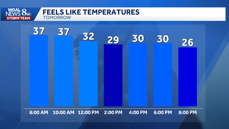
The coldest air of the season arrives Monday and lingers into Tuesday across South-Central Pennsylvania, making both days Impact Days for wind chills and blustery conditions.What’s happeningA cold front moved through the Susquehanna Valley Sunday and temperatures have been falling.Strong, persistent winds will amplify chilly temperatures Monday and Tuesday.Monday — Impact DayTiming: Noon into late afternoon and this evening.Morning: Temperatures in the 40s with a 10–20 mph breeze.Afternoon: Temperatures falling to the low–mid 40s; breezy conditions will make it feel like the 30s.Late afternoon/evening: Wind chills drop into the 20s.Although chilly temperatures are the story today, a few sprinkles or flurries are also possible.Tuesday — even colder Impact DayTiming: Especially cold Tuesday morning; winds increase through the day.Morning lows: Upper 20s, but wind will make it feel like the teens to low 20s.Daytime: Highs stuck in the low 40s; winds increase to 15–25 mph with higher gusts, producing wind chills in the 20s to low 30s.Thoughout the day: Wind chills won’t get out of the 30s.Snow? A snow shower or a few flurries are possible, mainly north of the PA Turnpike.Evening: Winds ease and conditions slowly recover.SOUTH-CENTRAL PA WEATHER RESOURCES: INTERACTIVE RADAR | ACTIVE WEATHER ALERTS | CURRENT CONDITIONS | HOURLY FORECAST | 10-DAY FORECAST | WEEKEND FORECAST | MAP ROOM | DOWNLOAD THE APP | WEATHER EMAILS
The coldest air of the season arrives Monday and lingers into Tuesday across South-Central Pennsylvania, making both days Impact Days for wind chills and blustery conditions.
What’s happening
A cold front moved through the Susquehanna Valley Sunday and temperatures have been falling.Strong, persistent winds will amplify chilly temperatures Monday and Tuesday.Monday — Impact DayTiming: Noon into late afternoon and this evening.Morning: Temperatures in the 40s with a 10–20 mph breeze.Afternoon: Temperatures falling to the low–mid 40s; breezy conditions will make it feel like the 30s.Late afternoon/evening: Wind chills drop into the 20s.Although chilly temperatures are the story today, a few sprinkles or flurries are also possible.Tuesday — even colder Impact Day
Timing: Especially cold Tuesday morning; winds increase through the day.Morning lows: Upper 20s, but wind will make it feel like the teens to low 20s.Daytime: Highs stuck in the low 40s; winds increase to 15–25 mph with higher gusts, producing wind chills in the 20s to low 30s.Thoughout the day: Wind chills won’t get out of the 30s.Snow? A snow shower or a few flurries are possible, mainly north of the PA Turnpike.Evening: Winds ease and conditions slowly recover.
SOUTH-CENTRAL PA WEATHER RESOURCES: INTERACTIVE RADAR | ACTIVE WEATHER ALERTS | CURRENT CONDITIONS | HOURLY FORECAST | 10-DAY FORECAST | WEEKEND FORECAST | MAP ROOM | DOWNLOAD THE APP | WEATHER EMAILS