
A strong cold front is moving through the Lehigh Valley, ushering in significantly colder temperatures and gusty winds that will dramatically change the region’s weather conditions Monday and Tuesday.
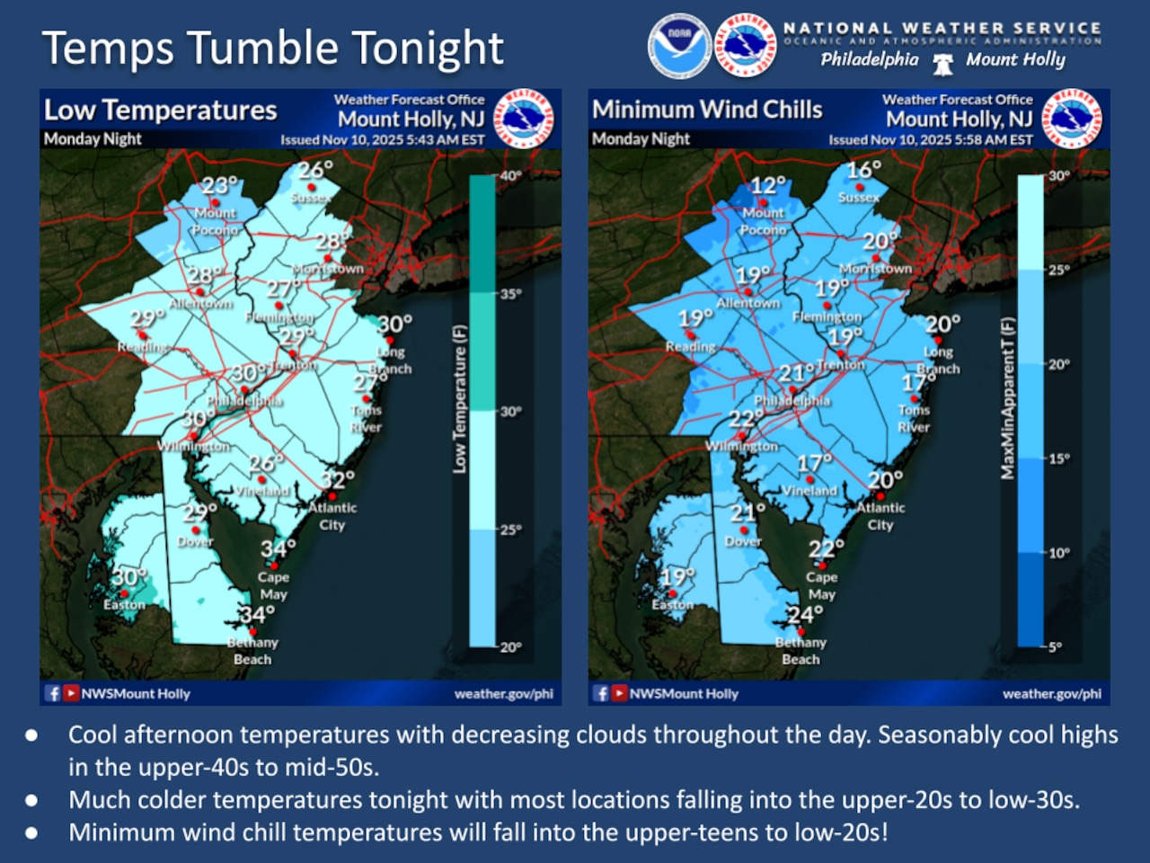
Residents should prepare for a sharp drop in temperatures and windy conditions that will make it feel much colder than recent days.
The National Weather Service forecast includes a slight chance of rain showers Monday afternoon in the Lehigh Valley, with daytime highs in the upper 40s. A chance of flurries is forecast between 10 a.m. and 4 p.m. on Tuesday, Veterans Day. This would mark the region’s first snowflakes of the season.
The cold front will bring west-northwest winds at 5-15 mph gusting up to 20 mph Monday and into the night. Wind chills are expected to drop into the teens by early Tuesday morning. Temperatures on Tuesday will struggle to reach the low to mid-40s, which is well below average highs for this time of year. The National Weather Service warns that wind chill values will make it feel even colder, with early morning temperatures potentially feeling like the teens.
Tuesday is expected to be a particularly raw day with continued strong winds. Westerly winds could gust up to 40 mph, keeping wind chill values in the low 30s during the afternoon. Skies will remain mostly cloudy to overcast, with limited sunshine and a persistent chilly atmosphere. Outdoor activities will be challenging, and residents are advised to dress in multiple layers and limit extended exposure to the cold.
AccuWeather.com reports widespread cold conditions east of the Rocky Mountains. The jet stream is plunging southward, with the first notable snow event of the season expected across Midwestern and Northeastern regions from Illinois to New York State.
“This storm pattern will introduce some of the coldest air seen for early November and that is the reason for the robust snow amounts expected in the Great Lakes and the far southern extent of the flurries into the southern Appalachians,” AccuWeather Senior Meteorologist Chad Merrill said.
The National Weather Service extended forecast for the Lehigh Valley suggests a gradual moderation of temperatures by Wednesday, with afternoon highs climbing back into the upper 40s to mid-50s. A weak cold front is expected to move through late Wednesday with minimal moisture, providing little change to the overall weather pattern.
By Thursday and Friday, high pressure will build in, bringing mostly dry conditions and temperatures slightly below seasonal averages. Winds will begin to diminish, offering some relief from the current gusty conditions. Residents can expect a relatively stable weather pattern heading into the weekend.
Follow your local forecast from AccuWeather at lehighvalleylive.com/weather with National Weather Service watches, warnings and other advisories available as they’re issued at lehighvalleylive.com/weather-alerts.
Current weather radar
Generative AI was used to produce an initial draft of this story, which was reviewed and edited by lehighvalleylive.com staff.
If you purchase a product or register for an account through a link on our site, we may receive compensation. By using this site, you consent to our User Agreement and agree that your clicks, interactions, and personal information may be collected, recorded, and/or stored by us and social media and other third-party partners in accordance with our Privacy Policy.