
CLEVELAND, OH (WOIO) – The snow belt — it’s part of every Northeast Ohioan’s vocabulary all winter, but does anyone know exactly where it is?
Not really. The snow belt is a geographical area that, climatologically speaking, receives more snow than the rest of Northeast Ohio. Any state connected to one of the Great Lakes actually has its own snow belt.
Northeast Ohio’s snow belt locations often see or possess many of the ingredients we need for efficient lake effect snow development: instability, fetch, wind shear, flow from upstream lakes and higher terrain. This isn’t to say that towns outside of the snow belt don’t see snow. They do. It’s just that, historically, snow belt communities see more of it.
Here in the Buckeye State, we have three snow belts: a primary, a secondary, and a tertiary.
Primary snow belt residents see more snow than secondary and tertiary snow belt-ers.
The primary snow belt is comprised of the following locations:
Ashtabula CountyLake CountyGeauga CountyEastern Cuyahoga CountyNorthern Portage CountyNorthern Trumbull County
The secondary snow belt is comprised of the following locations:
Southern Cuyahoga CountySouthern Lorain CountyNorthern and central Medina CountyNorthern and central Summit CountyCentral Portage CountyCentral and southern Trumbull County
The tertiary snow belt is comprised of the following locations:
Northern and central Richland CountyNorthern and central Ashland County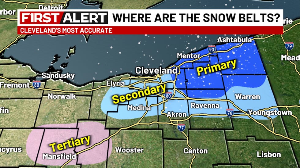 A look at the snow belts across Northeast Ohio(WOIO)
A common misconception is that coastal Lake Erie on the east side of Cleveland is part of the snow belt — it’s not.
Downtown Cleveland isn’t even in the snow belt because of its location on the north coast.
It’s often areas inland — five or so miles away from the lake — that see the most snow. Downtown Cleveland isn’t in the snow belt because of its close proximity to the lake.
Copyright 2025 WOIO. All rights reserved.