
Cooler & breezy Thursday; frost possible Thursday night in south-central Pennsylvania
Expect more sunshine with less warmth Thursday. Winds likely will still be breezy. Some areas of they Valley could wake up to some frost on the ground early Friday morning. Rain chances return late this weekend.
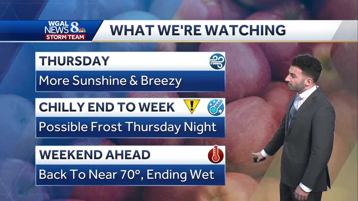
WHAT WE’RE WATCHING AS WE GET INTO OUR THURSDAY, IT’S GOING TO BE GETTING BREEZY AND ALSO A LITTLE BIT COOLER AS WELL. WE’LL HAVE MORE SUNSHINE AS WE GET INTO OUR AFTERNOON EARLIER TODAY. CLOUDS ARE VERY STUBBORN. THEY DIDN’T WANT TO BUDGE AN INCH, BUT WE FINALLY HAD SOME HIGH PRESSURE BUILD IN HELP TO INFLUENCE THE SKIES A LITTLE BIT. SO NOW WE’RE DEALING WITH SOME MAINLY CLEAR CONDITIONS. BUT AS WE GET INTO THURSDAY NIGHT INTO EARLY FRIDAY MORNING, CHECK THIS OUT. WE HAVE THE IMPACT ICON THERE FOR THURSDAY NIGHT. WE ARE EXPECTING A POSSIBLE FROST TO OCCUR AS WE GET INTO THE END OF THE WORKWEEK. SO DEFINITELY GOING TO BE A CHILLY END TO THE WEEK. BUT THEN AS WE GET INTO THE WEEKEND AHEAD, WE’RE BACK NEAR TO 70 DEGREES. MAJORITY OF THE WEEKEND WILL REMAIN DRY, BUT AS WE GET INTO LATE SUNDAY EVENING, GETTING INTO MONDAY, THAT’S WHEN WE’LL WILL END ON A WETTER NOTE. TEMPERATURES NOW TO THE MID 50S FOR LEBANON, 56 DEGREES C, SOME HIGH LEVEL CLOUDS IN THE BACKGROUND THERE, BUT OVERALL MAINLY CLEAR AS WE GET INTO THE REST OF THE OVERNIGHT PERIOD. HIGHS TODAY TOPPED OUT RIGHT AROUND 68 DEGREES AT HARRISBURG INTERNATIONAL AIRPORT. 66 IS WHAT WE EXPECT FOR THIS TIME OF YEAR. SO WE’RE RIGHT AROUND PAR IN TERMS OF THE HIGHS. BUT YOU CAN SEE RIGHT DOWN THE 46 DEGREES IS WHAT WE EXPECT FOR THE OVERNIGHT LOWS. EARLIER THIS MORNING HIT RIGHT AROUND 51 DEGREES. SO IN TERMS OF THE FORECAST FOR THE REST OF THE NIGHT, TONIGHT WILL BE HEADING DOWN TOWARDS THE LOWER TO MID 40S UNDER CLEAR SKIES, COOL CONDITIONS WITH SOME LIGHTER WINDS OUT OF THE NORTHWEST BETWEEN 5 AND 15MPH. THEN FOR TOMORROW MORNING, A BIT OF A CHILLY START, BUT IT WILL BE MOSTLY SUNNY, 48 TO 52 DEGREES. BIT OF A LIGHT BREEZE OUT OF THE NORTH NORTHWEST. THEN AS WE GET INTO THE AFTERNOON, THE WINDS PICK UP A QUITE QUITE A NOTCH HERE OUT OF THE NORTHWEST BETWEEN 10 TO 15MPH, POTENTIALLY GUSTING TO 20MPH IN SOME SPOTS, 60 TO 64 DEGREES FOR TEMPERATURES IN THE AFTERNOON. SO IT WILL BE REMAINING CRISP AND REFRESHING FOR THE DAY. SO THIS IS WHAT WE’RE WATCHING OUT FOR. YOU CAN SEE THE MAJORITY OF THE AREA INTO THE UPPER TO LOWER THE UPPER 30S LOW 40S RANGE, BUT YOU CAN SEE IN SOME OF THE MORE SCATTERED AREAS WHERE YOU CAN SEE THE MORE SHELTERED AREAS OR IN THE LOWER PARTS OF THE VALLEY COULD SEE TEMPERATURES DROPPING DOWN FROM 36 DOWN TOWARDS 33 DEGREES OVERNIGHT FOR TOMORROW. SO THAT’S SOMETHING THAT WE’RE GOING TO BE WATCHING OUT FOR. COULD SEE SOME SCATTERED AREAS OF FROST PRE-DAWN INTO FRIDAY MORNING. SO WHAT YOU SHOULD MAKE SURE THAT YOU DO IF YOU HAPPEN TO BE TRYING TO TAKE CARE OF SOME PLANTS, MAKE SURE YOU COVER THOSE PLANTS BECAUSE THOSE ARE SENSITIVE TO THE COLD. YOU WANT TO MAKE SURE YOU BRING THOSE INDOORS, WHETHER IN HEALTH FOR THE DAY TOMORROW. LOW POLLEN LEVELS, LOW MOLD LEVELS, GOOD AIR QUALITY AND A MODERATE UV INDEX FOR THE AFTERNOON RIGHT AROUND A 45 MINUTE BURN TIME. BUT THEN AS WE GET INTO THE WEEKEND, WE’RE DRY FOR THE FIRST FEW DAYS. BUT AS WE GET INTO SUNDAY AND MONDAY, THOSE ARE GOING TO BE OUR NEXT BEST CHANCES OF SHOWERS. TEMPERATURES INTO THE 50S, YOU CAN SEE LOW 50S TOWARDS YORK AT THIS TIME. WINDS ARE LOW AT THIS TIME. THEY’RE ABOUT LIGHT AND VARIABLE. BUT LOOK WHAT HAPPENS ONCE WE GET INTO THE AFTERNOON FOR THURSDAY. GETTING INTO ABOUT 15 TO 20 MILE PER HOUR SUSTAINED WINDS. ONCE WE GET INTO THURSDAY, RIGHT AROUND 4:00 IN THE AFTERNOON, ALL IS QUIET RIGHT NOW ON STORM TEAM LIVE RADAR NETWORK. HIGH PRESSURE SETTLED IN OVER THE AREA, HELPING TO USHER IN SOME OF THAT COOLER AND DRIER AIR INTO THE VALLEY. WE WILL START TO SLOWLY WARM AS WE GET INTO THE WEEKEND, BUT WE’LL BE ENJOYING SOME OF THE INFLUENCE OF HIGH PRESSURE AFTER DEALING WITH SOME OF THE DREARY CONDITIONS. THE CLOUDY CONDITIONS THAT WE WERE DEALING WITH OVER THE PAST FEW DAYS, NOW WE GET TO ENJOY SOME HIGH PRESSURE AND SOME SUNNY SKIES, BUT YOU CAN SEE SOME OFF AND ON CLOUDS. FEW CLOUDS FOR YOUR FRIDAY, BUT I WANT TO SHOW YOU OUR NEXT BEST CHANCE OF SHOWERS. THAT’S WHEN WE GET INTO SUNDAY. LATE SUNDAY IS WHEN I EXPECT TO SEE THOSE SHOWERS AND REALLY LINGER INTO OUR MONDAY. SO YOU CAN SEE THAT’S REFLECTED IN OUR TEN DAY FORECAST INTO THE 60S. FOR THE FIRST FEW DAYS, GETTING INTO THE WEEKEND OR THE SECOND HALF OF THE WEEKEND AT 72 DEGREES, THEN GETTING BACK DOWN TO T
Cooler & breezy Thursday; frost possible Thursday night in south-central Pennsylvania
Expect more sunshine with less warmth Thursday. Winds likely will still be breezy. Some areas of they Valley could wake up to some frost on the ground early Friday morning. Rain chances return late this weekend.

Updated: 10:30 PM EDT Oct 15, 2025
Tonight, high pressure will build across the Midwest and Northeast. Lows will fall to the low 40s under clear skies.Fewer clouds are in store Thursday with cooler highs in the low 60s. It will be breezy early, then the wind will diminish by evening as high pressure settles overhead. Watch out for cold temperatures Thursday night! Frost is possible, as lows fall to the mid-to upper 30s.After a cold start, Friday will be crisp and refreshing, with plenty of sunshine and highs around 64 degrees.Temperatures rebound to upper 60s to lower 70s this weekend, as high pressure drifts southeast. Expect dry weather on Saturday, then a slow-moving cold front will approach Sunday, leading to breezy conditions and rain late in the day.Rain likely continues Monday, and it will be cooler, with highs in lower 60s.Temperatures warm to the mid-60s Tuesday and Wednesday, then another front will knock temperatures down to the low 60s at the end of the week.Have a great rest of your night!~ Ryan
Tonight, high pressure will build across the Midwest and Northeast. Lows will fall to the low 40s under clear skies.
Fewer clouds are in store Thursday with cooler highs in the low 60s. It will be breezy early, then the wind will diminish by evening as high pressure settles overhead. Watch out for cold temperatures Thursday night! Frost is possible, as lows fall to the mid-to upper 30s.
After a cold start, Friday will be crisp and refreshing, with plenty of sunshine and highs around 64 degrees.
Temperatures rebound to upper 60s to lower 70s this weekend, as high pressure drifts southeast. Expect dry weather on Saturday, then a slow-moving cold front will approach Sunday, leading to breezy conditions and rain late in the day.
Rain likely continues Monday, and it will be cooler, with highs in lower 60s.
Temperatures warm to the mid-60s Tuesday and Wednesday, then another front will knock temperatures down to the low 60s at the end of the week.
Have a great rest of your night!
~ Ryan