
SHORT TERM FORECAST
TONIGHT: Mostly cloudy skies will gradually become partly cloudy later, brisk and chilly. There could be a flurry or sprinkle in the Poconos. Low: 31
SUNDAY: Sun mixing with clouds; brisk and quite cool. High: 49
SUNDAY NIGHT: Partly to mostly cloudy and chilly. Low: 30
Download the FREE 69News Weather App
FORECAST SUMMARY
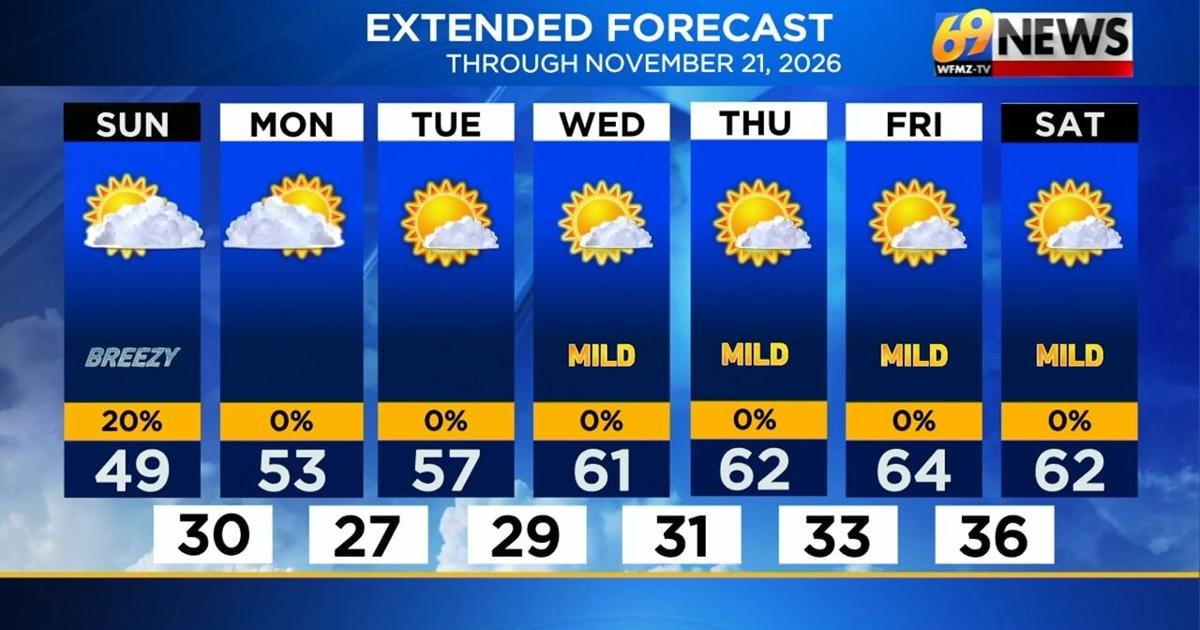
Our weather has definitely settled down a bit compared to this past Thursday, however we now are experiencing a December preview certainly when it comes to temperatures. Saturday featured mostly cloudy skies with even a few sprinkles or flurries across parts of the Poconos. High temperatures in many locations struggled to climb through the 40s and with northwest winds gusting 20-25 mph, we had wind chills in the 30s all throughout the day. Over the next 24 hours we don’t see much warming and the stiff breeze will remain, but we should get back to at least a little more sunshine Sunday with largely dry conditions. And the sunnier trend should continue into next week along with another very quiet stretch of weather and moderating temperatures. As of now we don’t anticipate any precipitation through at least next Saturday. Strong high pressure settles in by Monday and pretty much parks itself atop our region through all of the week ahead. This will lead to lighter winds along with a gradual return to an abundance of sunshine. High temperatures start the week around 50 degrees, but a nice warming trend takes over, pushing highs well into the 60s by the middle and end of the week. So after this chilly weekend, we’re looking at a pretty pleasant stretch of November weather. Just don’t get too used to it, because there’s already some indication that colder air could return around Thanksgiving week.
DETAILED FORECAST
TONIGHT
The mostly cloudy skies we’ve seen throughout much of our Saturday will linger into the first part of Saturday night. Later on at night, look for these clouds to clear out, mainly from the Lehigh Valley and I-78 corridor and points south. For those in the Poconos and far northwestern New Jersey, the thicker cloud cover will remain overnight and a few lake-effect flurries or sprinkles are not even out of the question. Overnight low temperatures should drop back into the lower 30s, but with northwest winds gusting up to 20 mph factored in, we’ll have wind chills eventually down into the 20s.
SUNDAY
The prospects for sunshine are a little brighter on Sunday, with at least a mostly sunny start to the day followed by a little uptick in the cloud cover by the afternoon. It will again be brisk and cool, with highs only in the upper 40s and northwest breezes returning too (sustained at 10-15mph, gusts to 20-25mph). Don’t be surprised if once again parts of the Poconos and far northwestern New Jersey see some lake-effect flurries or sprinkles, certainly early in the day.
EARLY NEXT WEEK
High pressure to our west will nudge closer to our area and successfully build in as we move through next week. That should ensure a decrease in clouds and wind, and a slow increase in temperatures as well as sunshine. Skies should become mostly sunny by Monday afternoon, and remain that way through the rest of the week. While a less gusty but still noticeable 10-15mph breeze may linger on Monday, winds should become lighter and average 10mph from Tuesday onward. Highs will finally get into the low 50s on Monday, then shoot up into the mid to upper 50s by Tuesday. Nighttime lows with clear skies and lighter winds will still be cold and likely below freezing.
LATER NEXT WEEK
High pressure moves overhead, ensuring light winds, plentiful sunshine, and a continued warming trend. With mostly sunny skies, highs should reach up around 60 to 65 degrees each afternoon, with nighttime lows becoming a little less cold and staying above freezing later in the week. The warm and mostly dry weather should continue into the start of next weekend as well.
TRACK THE WEATHER:
LINKS: HOUR BY HOUR | RADAR | TRAFFIC
Copyright 2026 Maranatha Broadcasting Co., Inc.. All Rights Reserved.