
Winds continue to ease in the Philadelphia area, though a steady northwest breeze will persist with gusts around 20 to 30 mph early, tapering off overnight. A few leftover sprinkles or flurries may linger, mainly north and west, before skies turn mostly clear. Temperatures will drop into the 30s for most areas, with upper 20s across the far north and northwest. Wind chills will make it feel like the 20s and even teens in the higher elevations.
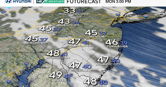
Monday stays dry but chilly as high pressure approaches from the southwest. Skies remain mostly sunny, though a few clouds may drift through during the afternoon. Winds will be lighter than Sunday but still breezy at times with gusts up to 25 or 30 mph. Highs range from the low 40s north to the upper 40s across Delaware and South Jersey.

CBS News Philadelphia
Clear and cold conditions continue Monday night before clouds increase on Tuesday as a weak system moves in from the west. Most of Tuesday stays dry, but a few light showers — or even a rain/snow mix in the Poconos, may develop Tuesday night into early Wednesday.
The rest of the week turns milder and more unsettled, with rain chances returning late Thursday into Friday and possibly again over the weekend.
Here’s your 7-day forecast:

CBS News Philadelphia
Monday: Windy day. High 48, Low 39.
Tuesday: Partly cloudy. High 49, Low 34.
Wednesday: Shower possible. High 49. Low 40.
Thursday: Mainly cloudy. High 50, Low 42.
Friday: Scattered showers. High 58, Low 48.
Saturday: Partly cloudy. High 58, Low 53.
Sunday: Partly cloudy. High 58, Low 44.