Evening commute could be wet as rain mixes with flakes in Western Pennsylvania
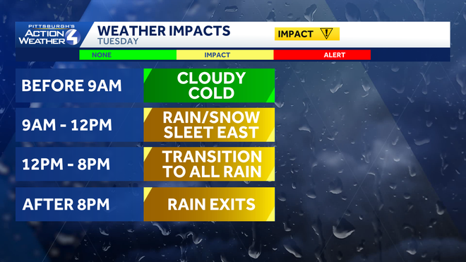
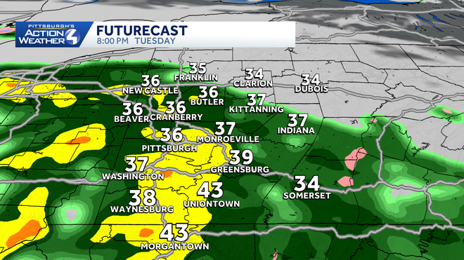
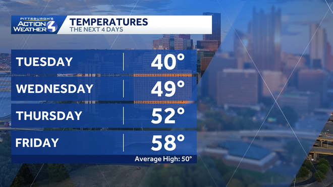
HOUR TUNNEL TIME. SITTING IN THE GREEN ACROSS THE BOARD. STILL, ASHLEY AND ELENA. IT IS AN IMPACT DAY, BUT ESPECIALLY FOR THE SECOND HALF OF THE DAY. GETTING INTO THE EVENING NOW WE’LL SEE A LITTLE BIT OF MIXING EARLY. WE’RE TALKING AROUND LUNCHTIME BEFORE IT CHANGES OVER TO SOME RAIN SHOWERS AND THE SHOWERS. EARLY AFTERNOON WILL BE VERY SPOTTY. HIT OR MISS. THAT HEAVIER RAIN COMING IN, ESPECIALLY AFTER 5:00. GOOD NEWS IS WE ARE DRYING OUT WEDNESDAY AND THURSDAY, SO LET’S BREAK DOWN THIS DAY. LET’S HELP YOU OUT HERE BEFORE 9:00. WE’RE GOING TO SEE THE CLOUDS MOVING IN AND COLD. SO AS YOU’RE SENDING KIDS OFF TO THE BUS STOP, EVERYTHING LOOKS GOOD. WE DON’T HAVE TO WORRY ABOUT MUCH. AS YOU’RE HEADING OFF TO WORK AND AS WE GET AFTER 9:00. VERY ISOLATED WITH THE POTENTIAL FOR RAIN, SNOW MIX AGAIN. COULD NOTICE A SPRINKLE, EVEN A FLURRY OR TWO. THE POTENTIAL TO HAVE SOME SLEET. ALSO, IN THOSE HIGHER ELEVATIONS EAST, THEN TRANSITIONING TO ALL RAIN AFTER 12:00, 1:00 AFTER 8:00, I THINK, IS WHEN WE’LL HAVE THOSE STEADIER RAIN SHOWERS ROLLING IN. AND THAT’S GOING TO LINGER INTO EARLY WEDNESDAY MORNING. BEFORE YOU GET UP, I’LL SHOW YOU THAT HERE ON FUTURE CAST IN JUST A SECOND, BUT WANT TO SHOW YOU OUR LIVE RADAR CURRENTLY IN OUR SATELLITE IMAGERY. THOSE CLOUDS ARE FILTERING IN SOME OF THESE SNOWFLAKES IN EASTERN OHIO FIZZLING OUT, HITTING SOME OF THIS DRIER AIR. THAT RAIN IS ON OUR DOORSTEP NOW. THE FIRST BATCH OF SOME HEAVIER RAIN JUST TO SOUTH IN NEAR CINCINNATI, GOING TO CONTINUE TO HIT PORTIONS OF WEST VIRGINIA. WE’LL BE WATCHING WHAT’S STILL EVEN WEST OF CHICAGO. ROLLING IN THAT LOW IS PASSING TO OUR SOUTH, AND WE ARE GOING TO BE ON THE FRINGE OF IT. SO OVERALL, WE ARE EXPECTING TO SEE THAT LIGHT MIXING, LIKE I SAID, TEN 11:00 VERY ISOLATED. MOST OF THE AREA WILL STAY DRY AND THEN WE’LL START TO SEE THIS AS WE WARM UP SLOWLY. I’M NOT TALKING 60, 70 DEGREES. I’M TALKING ABOVE 32. IT’S STILL GOING TO BE VERY COLD FOR US. WE’LL HAVE THAT COLD RAIN AROUND 5:00. YOU NOTICE A LOT OF THOSE SHOWERS, ESPECIALLY SOUTH OF THE CITY, BUT IT STARTS TO TAKE OVER A LITTLE BIT MORE WIDESPREAD AFTER 8:00, AND WE COULD HAVE SOME POCKETS OF HEAVY RAIN EMBEDDED HERE. THAT’S GOING TO EXTEND TILL ABOUT MIDNIGHT. 1:00, 2:00. BY THE TIME WE GET INTO EARLY WEDNESDAY, BY THE TIME YOU GET UP AND GET GOING, AS KIDS ARE GOING OFF TO THE BUS STOP, THINGS WILL QUIET DOWN FOR US. IT IS GOING TO BE COLD THOUGH TO START. THEN WE’RE BACK UP IN THE UPPER 40S WITH SOME SUNSHINE TRYING TO MIX IN, BUT STILL MOSTLY CLOUDY SKIES FOR US AS WE HEAD INTO WEDNESDAY AND THURSDAY. SO ISOLATED MIX, LATE MORNING, COLD RAIN BY THE AFTERNOON. STILL ISOLATED, BUT AFTER 7:00 8:00 LOOKS LIKE MORE WIDESPREAD RAIN. NOT AS BREEZY THOUGH TODAY, SO THAT’S A POSITIVE. AS WE HEAD INTO FRIDAY, WE’LL HAVE ANOTHER ROUND OF SOME SHOWERS, BUT STILL LOOKS GOOD AS WE HEAD INTO THE WEEKEND. EVEN THIS MORNING IT’S PRETTY NICE FOR YOU. IT’S JUST A COLD 126 RIGHT NOW IN PITTSBURGH, CURRENTLY 22 INTO KITTANNING. BUTLER AT 21 NEW CASTLE AND BEAVER. YOU’RE WAKING UP AT 20 DEGREES AGAIN. THESE ARE THE ACTUAL TEMPERATURES 19 RIGHT NOW IN WAYNESBURG, 22 IN UNIONTOWN. THERE’S YOUR FOUR DAY PLUS FOUR MORE FORECAST NEAR 60 DEGREES. BUT IT DOES COME WITH SOME RAIN ON FRIDAY AND HAVE AN EARLY MORNING SHOWER AS WE GET INTO SATURDAY, BUT LOOKS GREAT FOR LIGHT UP NIGHT AND MOST OF THE WPIAL CHAMPIONSHIP FOOTBALL GAMES GOING ON AT ACRISURE STADIUM, SO THAT WILL BE NICE IF YOU’RE ATTENDING THAT IN THE LOW 50S.
Evening commute could be wet as rain mixes with flakes in Western Pennsylvania

Updated: 6:23 AM EST Nov 18, 2025
The winter-like chill hangs on for one more day. Today is also an Impact Day for a cold rain that arrives throughout the day. Areas north of Pittsburgh, especially near US-422 and I-80, will see a few snowflakes mixed in this evening.Impact Day: A cold rain mixed with flurries Today begins with temperatures in the 20s with increasing clouds. A system from the south pushes cold rain and flurries into western PA later this morning. Some brief flurry action is possible after the morning commute for areas near and south of Pittsburgh. High temperatures will hover in the mid 30s to around 40 degrees. The majority of the precipitation arrives for the second part of the day. It will stay a widespread cold rain for Pittsburgh and points south. A mix of rain and snow will set up closer to US-422. The most widespread precipitation will be around for the evening commute, which prompts the Impact Day. Late week “mild” upThe mix of rain, flakes, and sleet will wrap shortly after midnight. We will see back-to-back dry days. The second half of the work and school week will be highlighted by another warmup. Mornings will still be a little chilly. But, high temperatures could reach 60 degrees again by Friday. More showers on Friday, drying out for the weekendThe warmth will also bring more rain showers. Friday looks to be the wettest day as showers will taper off early Saturday. If the timing holds, the forecast will bode well for the WPIAL championship games and Light Up Night. More sunshine is on tap for Sunday with seasonal highs around 50 degrees. TODAY – Impact Day: Increasing clouds with a few flurries around mid-morning. Widespread cold rain mixed with flurries north by late afternoon and this evening. High: 40°.TONIGHT: Rain and flurries end around midnight. Cloudy and chilly. Low: 34°.WEDNESDAY: Seasonal with intervals of sun and clouds. High: 49°, low: 37°.THURSDAY: Increasing clouds, high: 52°, low: 45°.
PITTSBURGH —
The winter-like chill hangs on for one more day. Today is also an Impact Day for a cold rain that arrives throughout the day. Areas north of Pittsburgh, especially near US-422 and I-80, will see a few snowflakes mixed in this evening.
Impact Day: A cold rain mixed with flurries
Today begins with temperatures in the 20s with increasing clouds. A system from the south pushes cold rain and flurries into western PA later this morning. Some brief flurry action is possible after the morning commute for areas near and south of Pittsburgh. High temperatures will hover in the mid 30s to around 40 degrees.

The majority of the precipitation arrives for the second part of the day. It will stay a widespread cold rain for Pittsburgh and points south. A mix of rain and snow will set up closer to US-422. The most widespread precipitation will be around for the evening commute, which prompts the Impact Day.

Late week “mild” up
The mix of rain, flakes, and sleet will wrap shortly after midnight. We will see back-to-back dry days. The second half of the work and school week will be highlighted by another warmup. Mornings will still be a little chilly. But, high temperatures could reach 60 degrees again by Friday.

More showers on Friday, drying out for the weekend
The warmth will also bring more rain showers. Friday looks to be the wettest day as showers will taper off early Saturday. If the timing holds, the forecast will bode well for the WPIAL championship games and Light Up Night. More sunshine is on tap for Sunday with seasonal highs around 50 degrees.
TODAY – Impact Day: Increasing clouds with a few flurries around mid-morning. Widespread cold rain mixed with flurries north by late afternoon and this evening. High: 40°.TONIGHT: Rain and flurries end around midnight. Cloudy and chilly. Low: 34°.WEDNESDAY: Seasonal with intervals of sun and clouds. High: 49°, low: 37°.THURSDAY: Increasing clouds, high: 52°, low: 45°.

