
Areas of dense fog this morning makes Thursday morning an Impact Day. Fog will start to lift around 9am.Impact Day: Dense Fog for the AM CommuteDense fog advisory and Freezing fog advisory in place until 9 am triggering an Impact Day for your morning drive. Visibility will be reduced to a quarter mile or less. A light glaze of ice, especially on bridges and overpasses could make driving conditions hazardous in parts of the region. Drive slowly, use your headlights, and leave plenty of distance ahead of you. A few showers possible late Friday into early SaturdayThe warmth will also bring a chance of rain showers late on Friday. The best chance to see rain will be locations south of Pittsburgh. It won’t be a washout, and most of what falls will be light. The wet weather will wrap up early Saturday morning.Mostly dry & mild November weekendThe timing of the rain’s exit bodes well for your weekend plans. We will see Saturday early morning rain followed by morning clouds and then sunshine. We will see sunshine on Sunday as well. Temperatures for Light Up Night festivities won’t be too cold. The trend for highs will stay in the low to mid 50s through Wednesday next week. We are watching another round of showers that could slow down pre-holiday travel next Tuesday.TODAY: Impact day with dense AM fog, Clouds return, seasonal. High: 52°TONIGHT: Mostly cloudy. Low 40°FRIDAY: Cloudy skies. evening rain showers. High: 55°, low: 40°.
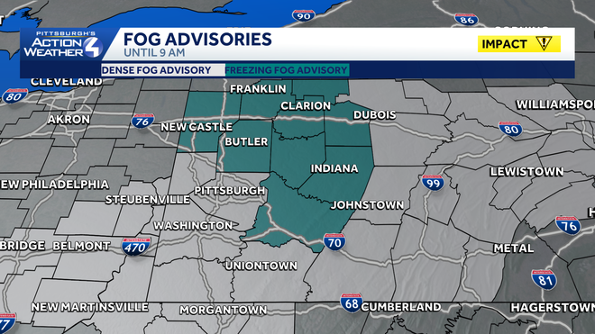
Areas of dense fog this morning makes Thursday morning an Impact Day. Fog will start to lift around 9am.
Impact Day: Dense Fog for the AM Commute
Dense fog advisory and Freezing fog advisory in place until 9 am triggering an Impact Day for your morning drive. Visibility will be reduced to a quarter mile or less. A light glaze of ice, especially on bridges and overpasses could make driving conditions hazardous in parts of the region. Drive slowly, use your headlights, and leave plenty of distance ahead of you.

A few showers possible late Friday into early Saturday
The warmth will also bring a chance of rain showers late on Friday. The best chance to see rain will be locations south of Pittsburgh. It won’t be a washout, and most of what falls will be light. The wet weather will wrap up early Saturday morning.
Mostly dry & mild November weekend
The timing of the rain’s exit bodes well for your weekend plans. We will see Saturday early morning rain followed by morning clouds and then sunshine. We will see sunshine on Sunday as well. Temperatures for Light Up Night festivities won’t be too cold. The trend for highs will stay in the low to mid 50s through Wednesday next week. We are watching another round of showers that could slow down pre-holiday travel next Tuesday.
TODAY: Impact day with dense AM fog, Clouds return, seasonal. High: 52°
TONIGHT: Mostly cloudy. Low 40°
FRIDAY: Cloudy skies. evening rain showers.
High: 55°, low: 40°.