
Isolated rain showers this evening; tracking first significant snowfall of the season across south-central Pennsylvania
The beginning of the work week starts on a quiet note, although a more significant storm system will bring our first decent snowfall of the season, with accumulations of 2-5″ of snow possible on Tuesday. We have the latest forecast
WEEKEND. RYAN, THAT DOES SEEM TO BE THE CASE HERE IN THE SUSQUEHANNA VALLEY, WITH SOME POTENTIAL SNOW HEADED OUR WAY THIS WEEK. YES, ABSOLUTELY. SO IT’S PROBABLY GOING TO LOOK A LITTLE BIT LIKE LIKE THAT SCENE YOU JUST SAW THERE IN THE ZOO. IT’S GOING TO BE LOOKING A LITTLE BIT LIKE THAT AS WE GET INTO OUR TUESDAY. BUT WE DO START THE WORKWEEK THOUGH ON A DRY NOTE, SO COULD SEE SOME ISOLATED SHOWERS FOR THIS EVENING. BRISK AND COLD START TO THE WEEK, BUT THE BIG STORY EVERYBODY’S BEEN TALKING ABOUT HAS BEEN TUESDAY. RYAN OR EVERYBODY ON THE STORM TEAM. HOW MUCH SNOW CAN I EXPECT FOR MY AREA? WE’RE GOING TO OUTLINE THOSE DETAILS FOR YOU RIGHT IN THIS FORECAST RIGHT NOW. THAT’S WHAT WE’RE GOING TO BE TRACKING AS WE GET INTO OUR TUESDAY. SO TEMPERATURES TODAY HIT RIGHT AROUND 42 DEGREES TODAY AT HARRISBURG INTERNATIONAL. WE ARE BELOW AVERAGE IN TERMS OF TEMPERATURES FOR THIS TIME OF THE YEAR, JUST ABOUT SIX DEGREES BELOW AVERAGE. ONLY HAD ABOUT 100TH OF AN INCH OF RAIN RECORDED AT HARRISBURG INTERNATIONAL AIRPORT. SO FOR THE REST OF THIS EVENING, EXPECT MOSTLY CLOUDY CONDITIONS. THEN WE’LL START TO SEE SOME PARTIAL CLEARING. CLOUDS ARE GOING TO BE A LITTLE BIT SLOW GETTING OUT OUT OF THE AREA. THIS THIS THIS EVENING. TEMPERATURES INTO THE 30S AND CLEARING SKIES BY TONIGHT. BRISK AND COLD GETTING DOWN INTO THE LOW 30S. AND THEN FOR TOMORROW, WE’RE LOOKING AT PARTLY SUNNY CONDITIONS, LIGHTER WINDS RIGHT AROUND 40 DEGREES IS WHAT WE EXPECT FOR TOMORROW. SO IN TERMS OF YOUR CHRISTMAS TREE LIGHTING FOR THIS EVENING AND PAXTANG ESPECIALLY RIGHT AT 630. HERE’S THE FORECAST FOR THE REST OF THIS EVENING, GOING DOWN INTO THE UPPER 30S. BY THE TIME YOU MAKE IT TO 8:00 AND 10:00 THIS EVENING. BUT LIKE I MENTIONED, THE CLOUDS ARE GOING TO BE A LITTLE BIT SLOW GETTING OUT OF THE AREA. BUT LET’S TALK ABOUT TUESDAY. TUESDAY IS AN ALERT DAY. AND THE REASON WHY IS BECAUSE WE’RE WATCHING THIS WINTER STORM THAT’S GOING TO BE COMING INTO THE MID-ATLANTIC AND EVENTUALLY UP THROUGH THE NORTHEAST. SO WHAT AND WHEN CAN YOU WHEN CAN YOU EXPECT THIS SNOW DEVELOPING? BY SUNRISE TUESDAY MORNING, MIXING WITH RAIN TO THE SOUTHEAST AND THEN ENDING BY LATE AFTERNOON TOTALS. RIGHT NOW, IN TERMS OF THE MAJORITY OF THE AREA, IT’S ABOUT 2 TO 5IN OF SNOW. SOME AREAS, ESPECIALLY NORTH AND EAST OF HARRISBURG, TOWARDS JUST FOR EXAMPLE, ELIZABETHVILLE. EVEN MANADA GAP, EVEN TOWARDS FORT INDIANTOWN GAP COULD SEE ISOLATED FIVE PLUS INCHES OF SNOW FOR FOR THOSE AREAS, BUT THE LOWEST OF THOSE OF THOSE TOTALS TOWARDS THE SOUTHEAST WITH THAT MIXING OF OF SOME SNOW AND ALSO SOME SLEET. POSSIBLE IMPACTS. HEAVY WET SNOW WITH A SLOW MORNING COMMUTE, CLOSINGS AND DELAYS. THEY DO SEEM TO BE LIKELY AS WE GET INTO OUR TUESDAY. SO IF YOU WANT TO TAKE A QUICK PICTURE HERE, THIS IS WHAT WE’RE EXPECTING FOR OUR TUESDAY. LIKE I MENTIONED, 2 TO 5IN POSSIBLE. YOU SEE THOSE ISOLATED POSSIBLE 5 TO 8 INCH MARKS UP TOWARDS OUR FAR NORTH AND EASTERN COMMUNITIES TOWARDS ELIZABETHVILLE, FOR EXAMPLE. AS YOU CAN SEE IN NORTHERN DAUPHIN AND NORTHERN LEBANON COUNTIES. NOW, IN TERMS OF THE INTENSITY FOR YOUR TUESDAY, IT WILL BE LIGHT SNOW, PRE-DAWN HOURS. SO STARTING RIGHT AROUND 4 OR 5:00 IN THE MORNING, THAT’S WHEN THE LIGHT SNOW IS GOING TO START TO COME IN TO OUR WESTERN COUNTIES. THEN FOR THE MORNING COMMUTE AND THE LATE MORNING COMMUTE, OR IF THERE’S ANY TRAVEL THAT YOU HAVE GOING ON, THIS IS WHERE THE BULK OF THAT SNOWFALL INTENSITY IS GOING TO BE FOR THESE TWO DIFFERENT TIMES. NOW EARLY AFTERNOON LOOKING LIGHT, BUT THEN IT’S GOING TO BE OUT OF HERE BY THE TIME WE GET INTO THREE, 4:00 IN THE AFTERNOON, TEMPERATURES INTO THE 40S. RIGHT NOW YOU CAN SEE 30S IN SOME AREAS, SEEING SOME LEFTOVER ISOLATED SHOWERS FROM OUR FIRST SYSTEM THAT WENT THROUGH AND BROUGHT SOME OF THAT SNOW EARLIER THIS MORNING. IN SOME AREAS, LIKE IN HARRISBURG AND PORTIONS OF SOUTHERN LANCASTER COUNTY, EVEN WE SAW SOME SNOW. BUT AS WE GET INTO OUR MONDAY LOOKING AT HIGH PRESSURE BUILDING IN FROM THE WEST, THAT’S GOING TO SETTLE IN OVERHEAD. BUT THEN HERE COMES SOME OF THE CLOUDS FROM TUESDAY. HERE COMES THIS IS GOING TO BE OUR FIRST SIGNIFICANT SNOWFALL OF THE SEASON. SO LET’S TIME IT OUT FOR YOU 4:00 5:00 IN THE MORNING. I’D SAY THAT’S WHEN WE START TO SEE SOME OF THAT SNOW PUSHING INTO OUR WESTERN COUNTIES. THEN BY THE TIME WE MAKE IT TO THE TO THE BUSY TUESDAY MORNING COMMUTE, 6 A.M., WE’RE LOOKING AT WIDESPREAD LIGHT TO MODERATE SNOW ACROSS THE AREA. BUT THEN THIS IS SOMETHING ELSE THAT WE’RE WATCHING. YOU SEE THIS RAIN MIX LINE. SEE THAT PINK IN THERE? THAT’S SLEET. WE COULD SEE A MIX OF SOME RAIN AND SLEET ALONG AND SOUTHEAST OF I-81. YOU CAN SEE THAT. AND AS WE GET INTO THE AFTERNOON, IT STARTS TO PUSH UP FURTHER TOWARDS THE NORTHWEST. SO THAT’S SOMETHING THAT WE GOT TO BE WATCHING AS WE GET INTO LATER ON TUESDAY. BUT THEN IT WILL BE OUT OF HERE BY THE TIME WE MAKE IT TO 4:00. SO THAT’S WHY WE HAVE TUESDAY AS AN ALERT DAY FOR THOSE TRAVEL IMPACTS AND FOR THE SNOW COMING IN WEDNESDAY, THURSDAY AND FRIDAY. COLD. STILL A LITTLE BIT BREEZY THOUGH. AS WE GET INTO THURSDAY. WE ARE WATCHING ANOTHER SYSTEM AS WE HEAD INTO NEXT WEEKEND WITH ANOTHER CHANCE OF SOME RAIN AND SNOW. WE’RE G
Isolated rain showers this evening; tracking first significant snowfall of the season across south-central Pennsylvania
The beginning of the work week starts on a quiet note, although a more significant storm system will bring our first decent snowfall of the season, with accumulations of 2-5″ of snow possible on Tuesday. We have the latest forecast

Updated: 6:53 PM EST Nov 30, 2025
It’s a quiet & cold start to the work week. Cloud cover will be slow to clear out this evening, ahead of incoming high pressure. It will be a little breezy with northwesterly winds around 10 to 15 mph.The News 8 Storm Team is tracking the first significant snowfall of the season as a winter storm approaches Tuesday making it an ALERT DAY.It is becoming more likely that a winter storm will move across the Mid-Atlantic and allow decent snowfall accumulation across the area. This would be the first decent snow accumulation of the season. TIMINGSnow will develop during the pre-dawn hours Tuesday morning, spreading from western counties and communities and spreading east. By 6 AM, snow will become widespread, so expect moderate snowfall intensity during the Tuesday morning commute and the late morning hours. By early afternoon, expect lighter snowfall rates/intensities. By this time, part of the area will continue to see mainly snow while areas to the southeast could see a mix to rain, especially Lancaster, York, and Adams counties. By around 3 – 4 pm, most of the snow or mix of snow and rain will have moved out of the Valley.TOTALSMost of the Susquehanna Valley will receive 2-5 inches. Communities north & east of Harrisburg may see up to 5 inches in isolated areas, such as portions of northern Dauphin & Lebanon counties. Southeast counites will see the lower snowfall amounts.IMPACTS Heavy, wet snow, slow morning commutes, closings and delays likely.Some other notes to make: The track of the storm will determine where the rain/snow line sets up and where accumulating snow occurs. It is still too early for snow totals as models continue to be very changeable, but plowable snow is a possibility for some. Stay tuned for updates this weekend.The rest of the week continues below average for early December. Highs will hover in the upper 30s to near 40 ° most days, with lows in the upper 20s.Next chance for rain or snow is Saturday.Have a great rest of your Sunday evening!~ Ryan
It’s a quiet & cold start to the work week. Cloud cover will be slow to clear out this evening, ahead of incoming high pressure. It will be a little breezy with northwesterly winds around 10 to 15 mph.
The News 8 Storm Team is tracking the first significant snowfall of the season as a winter storm approaches Tuesday making it an ALERT DAY.
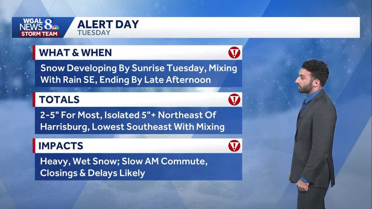
It is becoming more likely that a winter storm will move across the Mid-Atlantic and allow decent snowfall accumulation across the area. This would be the first decent snow accumulation of the season.
TIMING
Snow will develop during the pre-dawn hours Tuesday morning, spreading from western counties and communities and spreading east. By 6 AM, snow will become widespread, so expect moderate snowfall intensity during the Tuesday morning commute and the late morning hours. By early afternoon, expect lighter snowfall rates/intensities. By this time, part of the area will continue to see mainly snow while areas to the southeast could see a mix to rain, especially Lancaster, York, and Adams counties. By around 3 – 4 pm, most of the snow or mix of snow and rain will have moved out of the Valley.
TOTALS
Most of the Susquehanna Valley will receive 2-5 inches. Communities north & east of Harrisburg may see up to 5 inches in isolated areas, such as portions of northern Dauphin & Lebanon counties. Southeast counites will see the lower snowfall amounts.
IMPACTS
Heavy, wet snow, slow morning commutes, closings and delays likely.
Some other notes to make: The track of the storm will determine where the rain/snow line sets up and where accumulating snow occurs. It is still too early for snow totals as models continue to be very changeable, but plowable snow is a possibility for some. Stay tuned for updates this weekend.
The rest of the week continues below average for early December. Highs will hover in the upper 30s to near 40 ° most days, with lows in the upper 20s.
Next chance for rain or snow is Saturday.
Have a great rest of your Sunday evening!
~ Ryan