
Tonight, cloud cover will be continue to thin out and clear later overnight with temperatures dropping down to the low 30s.Monday, it’s a quiet & cold start to the work week, thanks to incoming high pressure. Northwesterly winds will be around 5 to 10 mph.The News 8 Storm Team is tracking the first significant snowfall of the season as a winter storm approaches Tuesday, making it an ALERT DAY.It is becoming more likely that a winter storm will move across the Mid-Atlantic and allow decent snowfall accumulation across the area. This would be the first decent snow accumulation of the season.TIMINGSnow will develop during the pre-dawn hours Tuesday morning, between 4-5 AM, spreading from western counties/communities and spreading east. By 6 AM, snow will become widespread, so expect moderate snowfall intensity during the Tuesday morning commute and the late morning hours. By early afternoon, expect lighter snowfall rates/intensities. By this time, part of the area will continue to see mainly snow while areas to the southeast could see a mix to rain, especially Lancaster, York, and Adams counties. By around 3 – 4 pm, most of the snow or mix of snow and rain will have moved out of the Valley.TOTALSMost of the Susquehanna Valley will receive 2-5 inches. Communities north & east of Harrisburg may see up to 5 inches or greater in isolated areas, such as portions of northern Dauphin & Lebanon counties. Southeast counties will see the lower snowfall amounts.IMPACTSHeavy, wet snow, slow morning commutes, closings and delays likely.Some other notes to make: The track of the storm will determine where the rain/snow line sets up and where accumulating snow occurs. It is still too early for snow totals as models continue to be very changeable, but plowable snow is a possibility for some. Stay tuned for updates this weekend.The rest of the week continues below average for early December. High pressure will dominate from Wednesday into Friday, promoting partly sunny conditions into next weekend. Highs will hover in the upper 30s to near 40 ° most days, with lows in the upper 20s.Next chance for rain or snow is Saturday, which we will continue to monitor as we get into the work week.Have a great rest of your night!~ Ryan
Tonight, cloud cover will be continue to thin out and clear later overnight with temperatures dropping down to the low 30s.
Monday, it’s a quiet & cold start to the work week, thanks to incoming high pressure. Northwesterly winds will be around 5 to 10 mph.
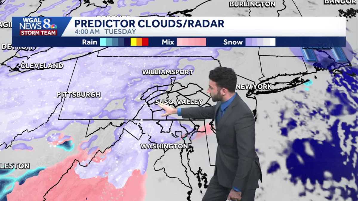
The News 8 Storm Team is tracking the first significant snowfall of the season as a winter storm approaches Tuesday, making it an ALERT DAY.
It is becoming more likely that a winter storm will move across the Mid-Atlantic and allow decent snowfall accumulation across the area. This would be the first decent snow accumulation of the season.
TIMING
Snow will develop during the pre-dawn hours Tuesday morning, between 4-5 AM, spreading from western counties/communities and spreading east. By 6 AM, snow will become widespread, so expect moderate snowfall intensity during the Tuesday morning commute and the late morning hours. By early afternoon, expect lighter snowfall rates/intensities. By this time, part of the area will continue to see mainly snow while areas to the southeast could see a mix to rain, especially Lancaster, York, and Adams counties. By around 3 – 4 pm, most of the snow or mix of snow and rain will have moved out of the Valley.
TOTALS
Most of the Susquehanna Valley will receive 2-5 inches. Communities north & east of Harrisburg may see up to 5 inches or greater in isolated areas, such as portions of northern Dauphin & Lebanon counties. Southeast counties will see the lower snowfall amounts.
IMPACTS
Heavy, wet snow, slow morning commutes, closings and delays likely.
Some other notes to make: The track of the storm will determine where the rain/snow line sets up and where accumulating snow occurs. It is still too early for snow totals as models continue to be very changeable, but plowable snow is a possibility for some. Stay tuned for updates this weekend.
The rest of the week continues below average for early December. High pressure will dominate from Wednesday into Friday, promoting partly sunny conditions into next weekend. Highs will hover in the upper 30s to near 40 ° most days, with lows in the upper 20s.
Next chance for rain or snow is Saturday, which we will continue to monitor as we get into the work week.
Have a great rest of your night!
~ Ryan