
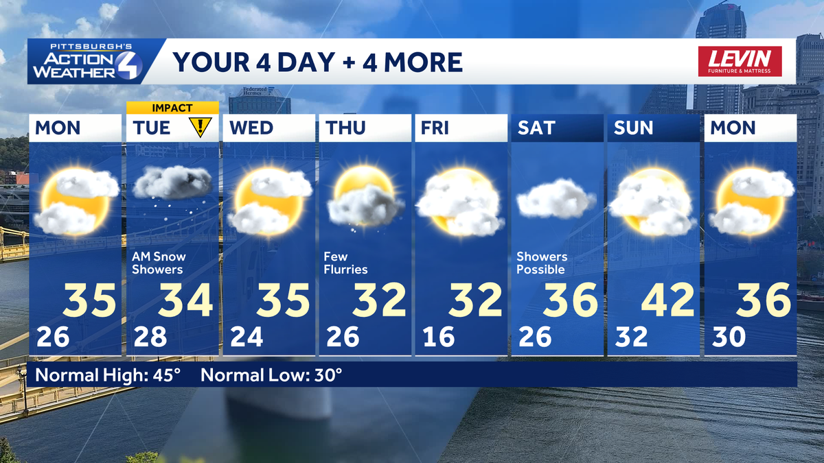
Welcome to December! Temperatures will remain on the brisk side all week. Tuesday is an Impact Day for accumulating snow that will be falling and sticking during morning commute. A few more flakes arrive on Thursday.Cold but not as windy todayThe wind has finally eased up, but the chill has not. Feels like temperatures are in the 20s this morning. Our “warm up” will only take us to the low and mid 30s this afternoon.Early sunshine will give way to clouds for the second half of the day. Skies will remain cloudy this evening as we await our first accumulating snow of the season.Impact Day: Snow for the Tuesday morning commuteSnow showers develop after midnight and will continue through noon. A Winter Weather Advisory is in effect between midnight and 1 p.m. Tuesday for the entire area. The timing and amounts prompts the Impact Day. Western PA will wake up to snow on the ground with additional accumulations through the morning commute. The snow will taper off by noon time. The evening drive should run more smoothly.This will be the first accumulating snow for the Pittsburgh. Amounts will be fairly uniform with 2″ to 4″. The majority of the snow will fall between 4 a.m. and 10 a.m. Locally higher amounts are possible near and north of I-80. A brief period of rain could “eat up” some of the snow totals near the PA-WV border.Winter chill lingers all weekHigh temperatures will be parked in the 30s for the first week of December. Sunshine will peak back in Wednesday. A weak clipper races through the area on Thursday with more flurries, but no accumulation. It will also be a breezy day. The coldest morning of the season so far will be Friday with temperatures in the teens. We are watching another system heading into the weekend. Temperatures are trending milder, so what falls may just be rain.TODAY: Some early sun, increasing PM clouds. Brisk, high: 35°.TONIGHT: Cloudy with snow developing after midnight. Low: 28°.TUESDAY – Impact Day: Morning snow. Cloudy and cold. High: 34°, low: 24°.WEDNESDAY: Still chilly with some sun. High: 35°, low: 26°.THURSDAY: Breezy with flurries. High: 32°, low: 16°.
PITTSBURGH —
Welcome to December! Temperatures will remain on the brisk side all week. Tuesday is an Impact Day for accumulating snow that will be falling and sticking during morning commute. A few more flakes arrive on Thursday.
Cold but not as windy today
The wind has finally eased up, but the chill has not. Feels like temperatures are in the 20s this morning. Our “warm up” will only take us to the low and mid 30s this afternoon.

Hearst OwnedHearst
December begins feeling like winter with highs in the mid 30s under increasing clouds.
Early sunshine will give way to clouds for the second half of the day. Skies will remain cloudy this evening as we await our first accumulating snow of the season.
Impact Day: Snow for the Tuesday morning commute
Snow showers develop after midnight and will continue through noon. A Winter Weather Advisory is in effect between midnight and 1 p.m. Tuesday for the entire area. The timing and amounts prompts the Impact Day. Western PA will wake up to snow on the ground with additional accumulations through the morning commute. The snow will taper off by noon time. The evening drive should run more smoothly.

Hearst OwnedHearst
All of western Pennsylvania will be under a Winter Weather Advisory between midnight and 1 p.m. Tuesday.
This will be the first accumulating snow for the Pittsburgh. Amounts will be fairly uniform with 2″ to 4″. The majority of the snow will fall between 4 a.m. and 10 a.m. Locally higher amounts are possible near and north of I-80. A brief period of rain could “eat up” some of the snow totals near the PA-WV border.

Hearst OwnedHearst
The first snowstorm of the season will bring accumulating snow through the Tuesday morning commute. Amounts will be around two or three inches for most neighborhoods.
Winter chill lingers all week
High temperatures will be parked in the 30s for the first week of December. Sunshine will peak back in Wednesday. A weak clipper races through the area on Thursday with more flurries, but no accumulation. It will also be a breezy day. The coldest morning of the season so far will be Friday with temperatures in the teens. We are watching another system heading into the weekend. Temperatures are trending milder, so what falls may just be rain.

Hearst OwnedHearst
The first week of December says winter with the cold temperatures and snow chances.
TODAY: Some early sun, increasing PM clouds. Brisk, high: 35°.
TONIGHT: Cloudy with snow developing after midnight. Low: 28°.
TUESDAY – Impact Day: Morning snow. Cloudy and cold. High: 34°, low: 24°.
WEDNESDAY: Still chilly with some sun. High: 35°, low: 26°.
THURSDAY: Breezy with flurries. High: 32°, low: 16°.