
SNOW TUESDAY | Tracking storm set to accumulate inches of snow across the south-central Pennsylvania
TODAY IS UNEVENTFUL. IT’S QUIET. IT’S THE CALM BEFORE THE STORM. LET’S TALK ABOUT TOMORROW. I WANT TO START THE CLOCK FOR YOU TOMORROW MORNING AT 3 A.M. THAT’S WHEN WE COULD START TO SEE SOME SNOW ENTERING OUR WESTERN COUNTIES, INCLUDING MIFFLIN AND FRANKLIN. NOW, AS WE HEAD INTO 4:00, 5 A.M. TOMORROW AT ABOUT THIS TIME, THE SNOW SHOULD BEGIN TO OVERSPREAD THE ENTIRE AREA. SO BY THE TIME THE MORNING COMMUTE HITS, IT WILL BE SNOWING AT A LIGHT TO MODERATE CLIP FOR MOST OF US. NOW HERE’S THE BIG PUZZLE PIECE. WATCH THIS RAIN SNOW LINE. YOU SEE IT CUTTING LANCASTER COUNTY RIGHT IN HALF. PARTS OF YORK COUNTY COULD EVEN GET INTO ADAMS COUNTY LATER IN THE MORNING. THAT’S GOING TO DRASTICALLY CUT YOUR SNOW TOTALS. SO ONCE YOU SWITCH OVER TO RAIN, YOU’RE NOT GOING TO GO BACK OVER TO SNOW. THERE COULD ALSO BE SOME SLEET IN THERE, ESPECIALLY THROUGH SOUTHERN LANCASTER, SOUTHERN YORK AND SOUTHERN ADAMS COUNTY. SO THESE AREAS SOUTHEAST ARE GOING TO SEE THE LOWEST SNOW TOTALS. MOST OF US WILL GET 2 TO 5IN AND THERE COULD BE SOME ISOLATED FIVE SIX INCH TOTALS AT ELEVATION TOWARDS SCHUYLKILL COUNTY, PERHAPS NORTHERN DAUPHIN, NORTHERN LEBANON COUNTY, BUT MOST SPOTS 2 TO 5. WITH THIS QUICK HITTING STORM. LOOK AT THIS. THIS IS 2 P.M. IT’S ALREADY OUT OF HERE. THE LAST FEW FLURRIES OR RAIN SHOWERS ARE PULLING OUT OF OUR EASTERN COUNTIES EARLY TOMORROW AFTERNOON, SO THIS WILL IMPACT THE MORNING COMMUTE FOR SURE TOMORROW. IT’S OUR FIRST ONE OF THE SEASON AND THE SNOW WILL BE HEAVY AND WET AND KIND OF SLIPPERY, SO USE CAUTION OR DELAY TRAVEL IF YOU CAN DURING THE MORNING HOURS TOMORROW. HERE’S THE EXPECTED ACCUMULATION MAP. AND NOTICE HOW THAT RAIN SNOW LINE REALLY CUTS OUR TOTALS. JUST A COATING TO TWO INCHES HERE IN THE WHITE, 2 TO 5 FOR MOST OF THE AREA. WITH THOSE HIGHER TOTALS POSSIBLE AT ELEVATION NORTH AND EAST TOMORROW MORNING, IT’S A SLOW GO. THERE’S JUST NO WAY AROUND IT. CLOSINGS OR DELAYS ARE LIKELY. POWER OUTAGE THREAT LOW. I’M NOT EXPECTING MUCH WIND AND THE HEAVY WET SNOW ISN’T ENOUGH TO REALLY BRING DOWN ANY LIMBS OR POWER LINES. VISIBILITY IS LOOKING OKAY BECAUSE THE WIND ISN’T GOING TO BE TERRIBLY STRONG IN THE SNOW, ISN’T GOING TO BE FALLING TOO HEAVILY. HERE’S OUR NEWS EIGHT STORM TEAM FORECAST TODAY. THIS IS AGAIN THE CALM BEFORE THE STORM. LOOK AT THIS PARTLY SUNNY 40. CAN’T ARGUE WITH THAT. IT’S A LITTLE BIT BELOW AVERAGE BY EIGHT DEGREES. BUT A NICE START TO DECEMBER TONIGHT. ALERTS BEGIN BECAUSE OUR SNOW WILL ARRIVE BETWEEN 3 TO 6 A.M. FROM WEST TO EAST, AND THAT SNOW WILL BE IN EFFECT FOR THE MORNING COMMUTE. WITH THAT RAIN SNOW LINE CREEPING IN FROM THE SOUTH DURING THE LATE MORNING AND EARLY AFTERNOON. SO ALL OF THIS IS OUT OF HERE. IT TAPERS BETWEEN LUNCHTIME 2 P.M. AND THE EVENING COMMUTE SHOULD BE FINE PROVIDED YOU GET THE ROADS TREATED, SALTED AND PLOWED, SO THEY SHOULD JUST BE WET FOR THE EVENING COMMUTE. HERE’S A LOOK AT YOUR TEMPERATURES. RIGHT NOW WE’RE AT 34 DEGREES IN LEWISTOWN, 32 LANCASTER AND YORK 35. IN HARRISBURG WE HAVE PARTLY CLOUDY SKIES OUT THERE, WIND SPEEDS STILL A LITTLE BRISK. WE HAVE SOME SPOTS IN THE DOUBLE DIGITS MAKING IT FEEL COLDER THIS MORNING. HERE’S OUR STORM ENERGY. RIGHT NOW IT’S OVER BY THE FOUR CORNERS. IT’S GOING TO GATHER SOME STEAM SWEEP ACROSS THE COUNTRY. LOW PRESSURE IS GOING TO FORM OVER THE SOUTHEAST HERE AND RACE UP THE EAST COAST TOMORROW. SO OUR STORM. IT’S A QUICK HITTER. IT’S NOT GOING TO LINGER. AND IT’S JUST ON THE EDGE OF BEING COLD ENOUGH TO SNOW IN SOME LOCATIONS. SO AGAIN TODAY, NOTHING TO WORRY ABOUT WEATHER WISE. CLOUDS COME IN TONIGHT. THAT SNOW DEVELOPS TOMORROW MORNING WITH THE RAIN SNOW LINE CUTTING OUR SOUTHEASTERN COUNTIES IN HALF. AND THEN THAT SYSTEM EXITS BY EARLY AFTERNOON EVENING TRAVEL SHOULD BE A OKAY, BUT WATCH OUT FOR ANY ICY, WET, UNTREATED SPOTS EARLY WEDNESDAY MORNING. WEDNESDAY WE GET SUNSHINE. WE DRY IT ALL OUT. BUT IT IS NOT GOING TO BE WARM THIS WEEK. LOOK AT THE HIGHS. AVERAGES ARE IN THE 40S AT THIS TIME OF THE YEAR, AND WE ARE GOING TO BE IN THE 30S FOR THE MAJORITY OF THE WEEK. IN FACT, ON FRIDAY, WE MIGHT NOT EVEN MAKE IT OUT OF THE 20S IN SOME LOCATIONS. HERE’S A LOOK AT OUR TEN DAY FORECAST. OF COURSE, WE HAVE THAT ALERT DAY FOR YOU TOMORROW, BUT THAT’S REALLY THE ONLY THING I WANT TO BRING YOUR ATTENTION TO IN THE TEN DAY. THERE’S A SYSTEM THAT COULD SLIDE BY TO OUR SOUTH SATURDAY AND NEXT WEEK STILL LOOKS COLD. REGINA I’M NOT EVE
SNOW TUESDAY | Tracking storm set to accumulate inches of snow across the south-central Pennsylvania

Updated: 6:12 AM EST Dec 1, 2025
The first plowable snowfall of the season is set to hit south-central Pennsylvania on Tuesday. A winter weather advisory is in effect for all of the Susquehanna Valley from 3 a.m. to 1 p.m., making Tuesday an Alert Day. Timing Early morning | Light snow will develop between 3 a.m. and 7 a.m., moving from west to east, with lows holding steady around 30 degrees. There may be 1 to 2 inches of snow already on the ground by 7 a.m.The snow will likely cause a slow commute with potential closings and delays. Snow to rain | As low pressure moves up the East Coast, warmer air will move into southern counties during the morning commute, changing snow to a brief period of sleet, then rain. Rain will taper after lunchtime, ending in the eastern counties by early afternoon.Slushy evening | After precipitation ends, highs will reach the low to mid-30s, making salt very effective at these temperatures, and roads should be slushy to wet for the evening commute. Icy Wednesday morning | Lows will fall to the upper 20s Tuesday night, so any untreated wet spots may be icy early Wednesday.Accumulation The rain will cut snow totals in the southern parts of Lancaster County, York County, and southeastern Adams County, where a coating to 2 inches of snow is expected. The rest of the Susquehanna Valley will pick up 2 to 5 inches of snow before the snow tapers from west to east after lunchtime. The highest totals will be at elevation north and east of Harrisburg, with 5 to 6 inches of snow possible in parts of northern Dauphin and Lebanon counties into Schuylkill and Northumberland counties. Did you capture the snow and would like to share with News 8? Send us your photos or videos at https://www.wgal.com/upload.Stay weather aware with WGAL’s online toolsRADAR: Track severe weather with WGAL’s interactive radar.LOCATION-BASED ALERTS: Instructions for activating our customized weather alerts are here.CLOSINGS: When severe weather strikes, see if businesses, churches or organizations have closed or delayed.ROAD CLOSURES: Our interactive traffic map is always updated with crashes, construction and road closures. It even has a weather radar overlay.EMAIL ALERTS: We’ll send you daily updates, or just alerts when severe weather is headed your way.HOUR-BY-HOUR: See what you can expect every day with the hourly forecast.WEEKEND WEATHER: Know what to expect before you make your plans.10-DAY FORECAST: Check WGAL’s extended forecast here.
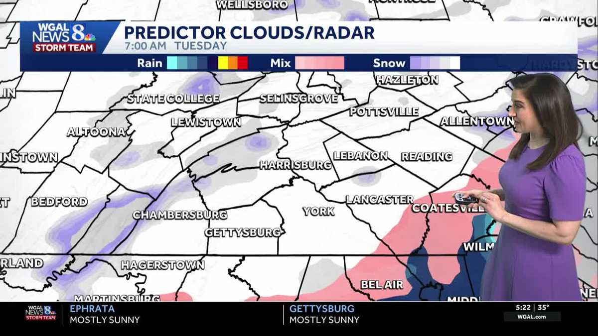
The first plowable snowfall of the season is set to hit south-central Pennsylvania on Tuesday.
A winter weather advisory is in effect for all of the Susquehanna Valley from 3 a.m. to 1 p.m., making Tuesday an Alert Day.
Timing
Early morning | Light snow will develop between 3 a.m. and 7 a.m., moving from west to east, with lows holding steady around 30 degrees. There may be 1 to 2 inches of snow already on the ground by 7 a.m.
The snow will likely cause a slow commute with potential closings and delays.
Snow to rain | As low pressure moves up the East Coast, warmer air will move into southern counties during the morning commute, changing snow to a brief period of sleet, then rain. Rain will taper after lunchtime, ending in the eastern counties by early afternoon.
Slushy evening | After precipitation ends, highs will reach the low to mid-30s, making salt very effective at these temperatures, and roads should be slushy to wet for the evening commute.
Icy Wednesday morning | Lows will fall to the upper 20s Tuesday night, so any untreated wet spots may be icy early Wednesday.
Accumulation
The rain will cut snow totals in the southern parts of Lancaster County, York County, and southeastern Adams County, where a coating to 2 inches of snow is expected.
The rest of the Susquehanna Valley will pick up 2 to 5 inches of snow before the snow tapers from west to east after lunchtime.
The highest totals will be at elevation north and east of Harrisburg, with 5 to 6 inches of snow possible in parts of northern Dauphin and Lebanon counties into Schuylkill and Northumberland counties.
Did you capture the snow and would like to share with News 8? Send us your photos or videos at https://www.wgal.com/upload.
Stay weather aware with WGAL’s online tools