
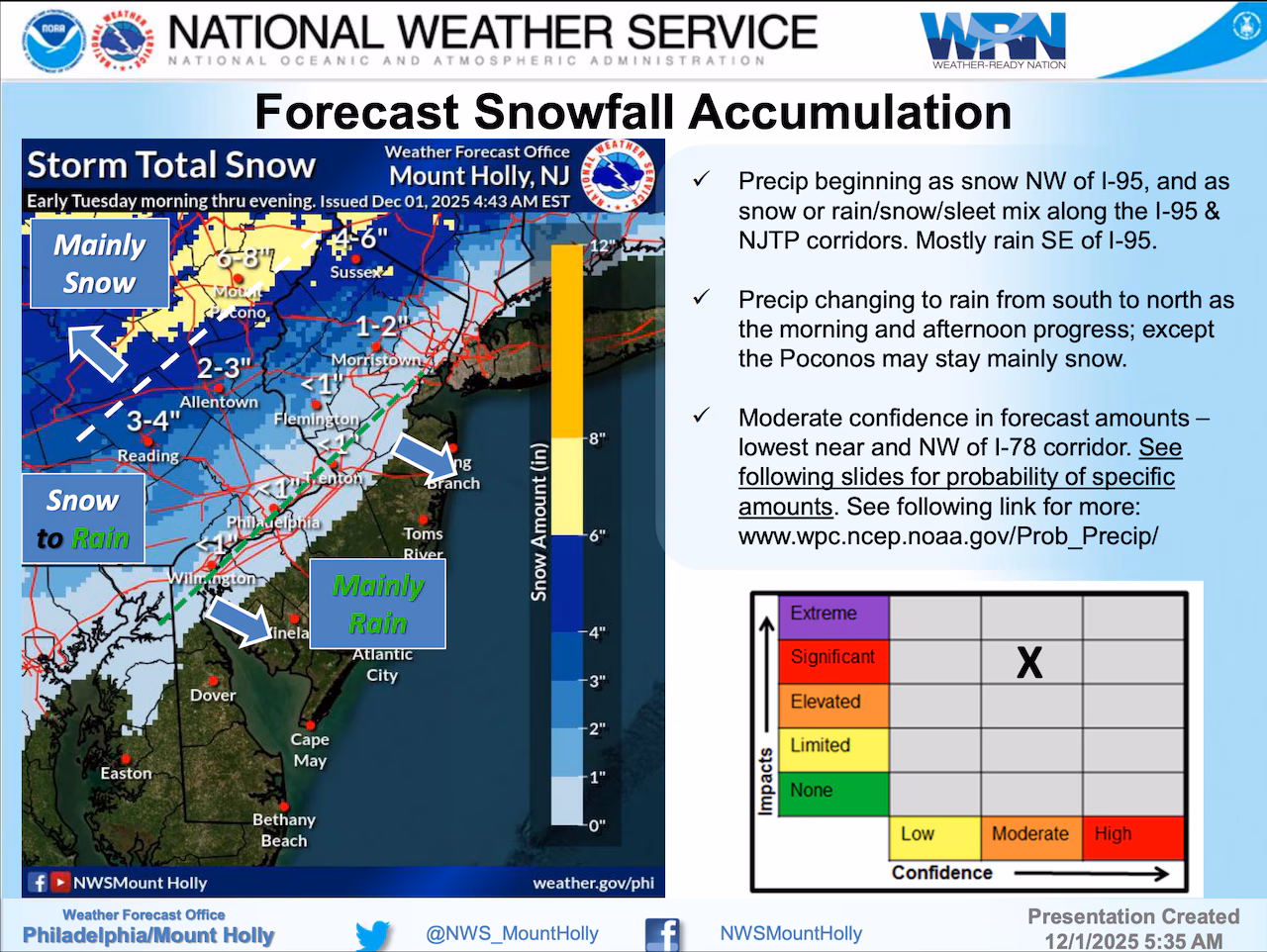
A Winter Weather Advisory is in effect Tuesday for the Lehigh Valley, with forecasters predicting the first significant snowfall of the season during the morning rush hour.
Areas along and north of Interstate 78 could see accumulating snow and sleet ranging from 2 to 5 inches. In the Pocono Mountains, total snow accumulations of 4 to 8 inches are possible. Carbon and Monroe counties are under a Winter Storm Watch in effect from late Monday night through Tuesday evening. A watch is more serious than the advisory in effect from 4 a.m. to 1 p.m. Tuesday for Berks, Lehigh, Northampton and Warren counties.
The National Weather Service warns that Tuesday’s storm will begin as snow, particularly in the morning hours, before transitioning to rain by Tuesday afternoon.
The southern Poconos and northwestern New Jersey have the highest probability of experiencing plowable snow, with a 60-90% chance of accumulations exceeding 2 inches. Temperatures will hover near freezing in the Poconos and in the upper 30s to lower 40s in eastern Pennsylvania.
Residents should anticipate potentially hazardous morning commute conditions, with snowfall likely to create slick road surfaces. The first snowfall of the season during morning rush hour could cause more significant travel impacts than typical early-season snow events.
The forecast storm follows some snow Sunday morning in the Lehigh Valley region that didn’t amount to much. At Lehigh Valley International Airport, the National Weather Service on Sunday recorded 0.2 of an inch of snow that represented the first accumulation of the season, but it melted quickly in all but a few spots of unpaved surfaces.
Tuesday’s storm system will move quickly, with precipitation ending from west to east by the evening. Temperatures will drop into the 20s Tuesday night, potentially creating black ice conditions where snow melts and refreezes on roadways. By Wednesday, high pressure will bring mostly sunny skies and continued below-normal temperatures, with highs in the mid-30s to low 40s.
Looking ahead, another cold front is expected Thursday, bringing even colder temperatures. Overnight Thursday into Friday is forecast to be the coldest night so far this season, with widespread low temperatures in the teens and wind chills in the single digits to mid-teens. Another potential precipitation system may arrive late Friday into the weekend, though details remain uncertain.
Current weather radar
Generative AI was used to produce an initial draft of this story, which was reviewed and edited by lehighvalleylive.com staff.