
Projected snowfall totals across eastern Pennsylvania have dropped slightly for an expected winter storm Tuesday, the region’s first of the season, though there still remains some uncertainty around the forecast.
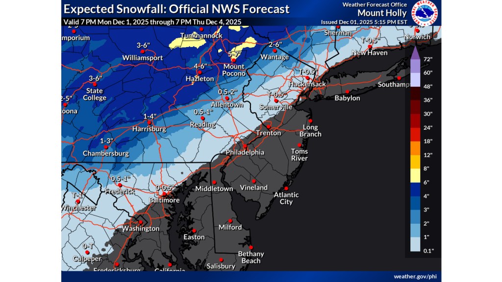
The latest snowfall projection map from the National Weather Service forecast office in Mount Holly, New Jersey, shows most of the Lehigh Valley getting between a half-inch and two inches of snow. The northern tier of the Lehigh Valley and southern Poconos are more likely to be in the range of 3-4 inches.
However, the highest elevations of the Poconos are still expected to see more significant snowfall accumulations, with the weather service’s map showing up to 7 inches around Mount Pocono in Monroe County.
In its forecast discussion late Monday afternoon, the weather service noted the system will arrive slightly later than initially expected, with precipitation holding off until closer to daybreak.
“Due to a later arrival, and more warm air in place at the onset of the precipitation, this has cut back on snow totals and how far southeast they extend,” the weather service noted.
The weather service said the chances for plowable snow remains high for the areas “along and north of I-78,” extending north into the Poconos. Areas southeast of the Lehigh Valley could see mostly rain.
A winter weather advisory remains in effect for Lehigh, Northampton and Berks counties from 4 a.m. to 1 p.m. Tuesday. With the lower snowfall projections, a winter storm watch that had been issued for Monroe and Carbon counties has been downgraded to an advisory.
Snow won’t be the only problem for the Lehigh Valley on Tuesday, with the advisory warning of a light glaze of ice accumulating. Slippery roads have the potential to create a messy morning commute, the weather service warns.
Anticipating hazardous conditions, PennDOT announced a number of vehicle restrictions across eastern Pennsylvania ahead of the storm. Speed limits will be reduced and tractor-trailers restricted on several roads, including Route 22 from Interstate 78 to the New Jersey border, and the Pennsylvania Turnpike Northeast Extension (Interstate 476). Those restrictions take effect at 6 a.m. Tuesday.
The precipitation is expected to turn over to all rain by midday, according to forecasters. After the precipitation moves out, the rest of the week should be clear, but chilly, with overnight low temperatures dipping into the low 20s and teens.
Looking ahead, there’s another chance for snow Friday night, according to the weather service.
Here is the extended forecast:
Tuesday: Rain and snow, possibly mixed with sleet, becoming all rain after noon. High near 38. East wind 5 to 10 mph becoming north in the afternoon. Chance of precipitation is 100%. New snow and sleet accumulation of 1 to 2 inches possible.
Tuesday Night: Mostly cloudy, then gradually becoming mostly clear, with a low around 24. Northwest wind around 10 mph.
Wednesday: Mostly sunny, with a high near 38. Northwest wind around 5 mph.
Wednesday Night: Partly cloudy, with a low around 24. Calm wind becoming southwest around 5 mph.
Thursday: Partly sunny, with a high near 38.
Thursday Night: Mostly clear, with a low around 11.
Friday: Partly sunny, with a high near 29.
Friday Night: A chance of snow. Mostly cloudy, with a low around 18. Chance of precipitation is 30%.
Saturday: Partly sunny, with a high near 38.
Saturday Night: Mostly cloudy, with a low around 24.
Sunday: Partly sunny, with a high near 38.