
Tuesday is an Impact Day for our morning snow showers. The afternoon will feature mostly cloudy skies with flurries, but little additional accumulation.Impact Day – Morning Snow ShowersOur system responsible for the snow will move through the area this morning and produce widespread snow showers. The heaviest snow will fall before 8 a.m. Some mixing of rain or freezing rain in the Laurel Highlands is possible as warmer air tries to nudge northward, but even if we don’t see a brief period of mixed precipitation, the slightly warmer air will likely cut into snow totals there. By the time we are done, expect widespread two-to-four-inch snow totals with less in and against the Laurel Highlands and slightly more north of Interstate 80.A Winter Weather Advisory is in effect for everyone until 1 p.m.Flurries and Colder Thursday and FridayA quick passing cold front will drop into the area Thursday morning. This will drop flurries to light snow showers early, with snow accumulations of about a half inch or less.The cold front will reinforce the cold air in the area as we start in the teens to single digits Friday morning. Temperatures will only return to near freezing Friday afternoon.Flurry Chances ContinueHighs warm a bit this weekend with the first additional flurry chance on Sunday. Another flurry chance gets here on Tuesday. Temperatures remain cold through the middle of next week.TODAY – IMPACT DAY: Morning snow showers then cloudy with flurries. High: 34°.TONIGHT: Mostly cloudy. Low: 22°.TOMORROW: Mostly cloudy and cold. High: 33°, low: 26°.THURSDAY: Morning flurries the mostly cloudy. High: 32°, low: 12°.
PITTSBURGH —
Tuesday is an Impact Day for our morning snow showers. The afternoon will feature mostly cloudy skies with flurries, but little additional accumulation.
Impact Day – Morning Snow Showers
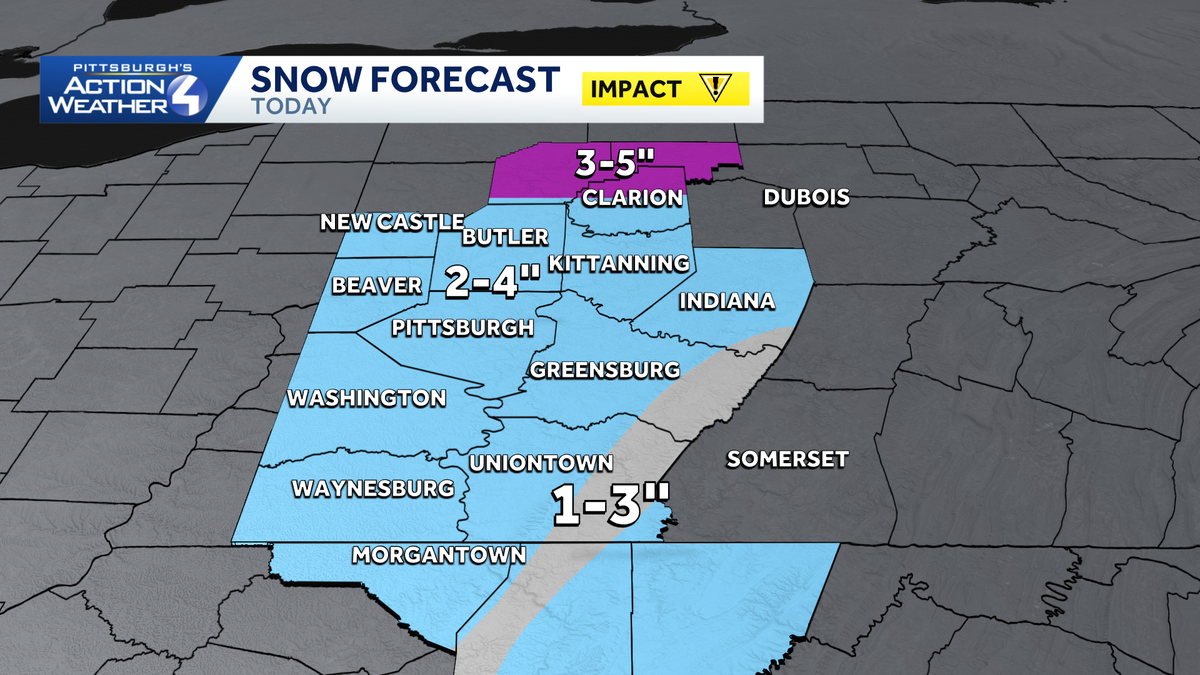
Our system responsible for the snow will move through the area this morning and produce widespread snow showers. The heaviest snow will fall before 8 a.m. Some mixing of rain or freezing rain in the Laurel Highlands is possible as warmer air tries to nudge northward, but even if we don’t see a brief period of mixed precipitation, the slightly warmer air will likely cut into snow totals there. By the time we are done, expect widespread two-to-four-inch snow totals with less in and against the Laurel Highlands and slightly more north of Interstate 80.

Hearst Owned
Generally widespread 2-4″ of snow from our system this morning.
A Winter Weather Advisory is in effect for everyone until 1 p.m.
Flurries and Colder Thursday and Friday
A quick passing cold front will drop into the area Thursday morning. This will drop flurries to light snow showers early, with snow accumulations of about a half inch or less.

Hearst Owned
A quick passing cold front will bring flurries to light snow Thursday morning.
The cold front will reinforce the cold air in the area as we start in the teens to single digits Friday morning. Temperatures will only return to near freezing Friday afternoon.

Hearst Owned
A frigid start to Friday with temperatures near 10.
Flurry Chances Continue
Highs warm a bit this weekend with the first additional flurry chance on Sunday. Another flurry chance gets here on Tuesday. Temperatures remain cold through the middle of next week.

Hearst Owned
Several snow chances over the course of the next week, but the most impactful one is Tuesday morning.
TODAY – IMPACT DAY: Morning snow showers then cloudy with flurries. High: 34°.
TONIGHT: Mostly cloudy. Low: 22°.
TOMORROW: Mostly cloudy and cold. High: 33°, low: 26°.
THURSDAY: Morning flurries the mostly cloudy. High: 32°, low: 12°.