
LET’S GO TO CHRISTINE AND SEE THE TIMING FOR THIS. AND WE’RE TAKING A LOOK AT OUR PRECIPITATION CHANCES FOR TODAY. THEY WILL BE DEVELOPING FIRST A SNOW PRE-DAWN. AND THEN FOR THE MORNING COMMUTE WIDESPREAD SNOW WITH RAIN ALREADY TRYING TO NOSE INTO OUR SOUTHERN COUNTIES BY LATE MORNING. I THINK MOST OF LANCASTER, YORK, PARTS OF ADAMS COUNTY WILL BE SEEING RAIN WHILE THE REST OF THE AREA IS STILL SEEING SNOW. BUT THIS SYSTEM IS GOING TO TAPER QUICKLY BEFORE LUNCHTIME. EVEN ALREADY IN WESTERN COUNTIES AND RIGHT AFTER LUNCHTIME IN EASTERN COUNTIES, IT SHOULD BE ENDING. SO WE GET A MIX OF RAIN AND SNOW OUT OF THIS ONE, BUT IT DOES START AS SNOW AND I EXPECT THE SNOW TO FILL IN AREA WIDE BY 7 A.M. RIGHT NOW I’M STARTING TO SEE SOME OF THOSE BRIGHTER RETURNS ON THE RADAR THROUGH FRANKLIN, ADAMS COUNTIES. EVEN WESTERN PORTIONS OF MIFFLIN, JUNIATA, PERRY, CUMBERLAND COUNTY COULD SEE SOME FLAKES STARTING TO FLY THERE. SO THIS WILL BE MOVING EAST AS THE MORNING GOES ON. LOOK AT THAT. THAT 7 A.M. EVERYBODY IS SEEING SNOW TO START. WATCH THE RAIN SNOW LINE, THOUGH. IT STARTS TO CREEP INTO LANCASTER, YORK, TOUCHING SOUTHERN ADAMS COUNTY. AND THIS IS GOING TO DRASTICALLY CUT OUR SNOW TOTALS IN THESE SPOTS. SO COATING TO TWO WHERE WE HAVE THE MIX 2 TO 5IN. ELSEWHERE IN THE SUSQUEHANNA VALLEY. SO YOU CAN SEE THE MIX LINE MIGHT EVEN COME ALL THE WAY UP TO 81 BY THE TIME PRECIPITATION ENDS. BUT THEN IT SHUTS OFF PRETTY QUICKLY. THIS IS 1 P.M., AND WE STILL HAVE A FEW RAIN SHOWERS IN LANCASTER COUNTY. BUT THEN AFTER THAT, THE PRECIPITATION IS OVER. AND THAT’S GOOD NEWS BECAUSE WE WANT TO DRY OUT WITH THE BREEZE PICKING UP LATER THIS EVENING. BUT AFTER TEMPERATURES FALL TO THE 20S TONIGHT, HOPEFULLY IT WILL BE MOSTLY DRY. I JUST WANT YOU TO WATCH OUT FOR SOME ISOLATED SLICK SPOTS. HERE’S OUR EXPECTED ACCUMULATIONS. BECAUSE OF THE MIX TO RAIN. NOTICE THAT WHITE STRIPE? THAT’S WHERE WE HAVE A COATING TO TWO IN THE AREA, 2 TO 5IN IN THE BLUE. AND THEN THERE COULD BE SOME ISOLATED FIVE, MAYBE AN ISOLATED SIX INCH TOTAL. AS YOU HEAD INTO SCHUYLKILL COUNTY AND UP INTO THE POCONOS, BUT LARGELY 2 TO 5IN WHERE YOU STAY SNOW THROUGH THE ENTIRE STORM. HERE’S OUR NEWS EIGHT STORM TEAM FORECAST TODAY. WE HAVE SNOW DEVELOPING THIS MORNING. MIXING TO RAIN SOUTHEAST AND ENDING BETWEEN 11 AND 2 WEST TO EAST TEMPERATURES. THIS AFTERNOON THEY GET INTO THE MID 30S. SO SALT WILL BE VERY EFFECTIVE AT THOSE TEMPERATURES. FOR CLEANUP FOR TONIGHT. PARTLY CLOUDY. FEELING LIKE THE TEENS THOUGH. THAT WIND PICKS UP 5 TO 15MPH. AND CHECK OUT OUR TEMPERATURES. THEY DROP TO THE 20S, SO ANY WET, UNTREATED SPOTS COULD BECOME ICY OVERNIGHT. TOMORROW PARTLY SUNNY, COLD 36 TO 40. AVERAGE HIGHS ARE AROUND 48, SO AT LEAST THE WIND WON’T BE VERY STRONG TOMORROW. BUT I DO SEE BLUSTERY WINDS ON THURSDAY FOR US ON THE ALMANAC. YESTERDAY’S HIGH AHEAD OF THE STORM WE GOT TO 43, SO THE SURFACE WARMED UP PRETTY NICELY. RIGHT NOW WE REALLY HAVEN’T SEEN A HARD FREEZE OVERNIGHT. WE’RE HOVERING RIGHT AROUND THAT FREEZING MARK. SOME SPOTS ARE IN THE UPPER 20S. MOST ARE IN THE LOW 30S. SO I DO EXPECT TEMPERATURES TO HOLD IN THE LOW 30S AS PRECIPITATION BEGINS. BUT LOOK AT THIS. THERE IS A WARMER NOSE TO THIS SYSTEM. YOU CAN SEE THAT RAIN TRYING TO SNEAK UP TOWARD OUR SOUTHEASTERN COUNTIES. I DO THINK YOU’LL GET SOME SNOW INITIALLY IN LANCASTER COUNTY, BUT YOU’RE GOING TO SEE MOSTLY RAIN FROM THIS EVENT. LET ME SHOW YOU ON THE PREDICTOR HERE. YOU CAN SEE THAT RAIN SNOW LINE ALMOST ALL THE WAY UP TO 81. BY THE TIME PRECIPITATION ENDS. BUT THIS SYSTEM QUICKLY LIFTS OUT. AND WE CLEAR OUT TONIGHT. TOMORROW. NOT QUITE AS WINDY AS IT WILL BE OVERNIGHT. THE WIND DIES DOWN WITH HIGH PRESSURE OVERHEAD, AND THEN WE GET THIS FRONT IN MAINLY DRY FRONT. ON THURSDAY THERE MIGHT BE A FEW FLURRIES, BUT BOY, THAT FRONT’S GOING TO LEAVE ITS MARK BECAUSE BY FRIDAY WE MIGHT NOT GET TO 30 DEGREES IN SOME AREAS. SATURDAY AND SUNDAY WE REBOUND TO THE UPPER 30S, BUT THAT’S STILL ABOUT TEN DEGREES BELOW AVERAGE. SHOULD BE A MAINLY DRY WEEKEND FOR US. SOME FLURRIES AT TIMES OR A FEW SNOW SHOWERS AT TIMES NEXT WEEK. HARD TO PIN DOWN RIGHT NOW, BUT I’LL TELL YOU WHAT. TEMPERATURES ARE GOING TO STAY IN T
SNOW TODAY | Tracking the timing, totals and impacts across south-central Pennsylvania

Updated: 7:29 AM EST Dec 2, 2025
The WGAL Storm Team is tracking the first plowable snowfall of the season. A winter weather advisory is in effect for all of the Susquehanna Valley from 3 a.m. to 1 p.m., making Tuesday an Alert Day.The snowstorm is making its way across the commonwealth, impacting the morning commute. Click here to watch the snowfall on WGAL’s Skycams. TIMINGMorning | First widespread snow arrives west to east by 7 a.m. Snow to Mix and Rain | As coastal low pressure moves up the East Coast, warmer air pushes into southern counties between 8 and 10 a.m.; Snow will change to a brief period of sleet, then rain in Lancaster, York and southeastern Adams countiesEarly Afternoon | Rain will taper after lunchtime in Adams County and end in eastern counties by 2 p.m. as temperatures climb into the mid-30sAfternoon and Evening | Precipitation ends; Highs reach the mid to upper 30sOvernight into Wednesday Morning | Lows drop into the upper 20s; Any untreated wet spots may refreeze, creating icy patches TOTALSRain will reduce snow totals in the southeastern counties, but higher elevations north and east of Harrisburg are still expected to see the greatest accumulations.Lancaster, York and southeastern Adams counties: Coating to 2 inches, followed by rainMost of the Susquehanna Valley: 2 to 5 inches of snow Northern Dauphin, Lebanon, Schuylkill and Northumberland counties: Up to 5 inches of snowCLOSINGS, DELAYSThere are already more than 300 closings and delays across the Susquehanna Valley. Click here to view the full list. TRAVEL IMPACTSMorning Commute | Slow with reduced visibility and slick; Snow will be light to moderate but heavy, wet and slippery on roadsAfternoon and Evening Commute | Salt will be effective, leading to slushy and wet roadsOvernight to Wednesday Morning | Untreated wet spots may refreeze, creating icy patches; Watch for black icePennDOT has reduced the speed limits and set restrictions on nearly all major highways in the Susquehanna Valley. Click here to see what routes are impacted. Did you capture a moment that you would like to share with News 8? Send us your photos or videos at https://www.wgal.com/upload.Stay weather aware with WGAL’s online toolsRADAR: Track severe weather with WGAL’s interactive radar.LOCATION-BASED ALERTS: Instructions for activating our customized weather alerts are here.CLOSINGS: When severe weather strikes, see if businesses, churches or organizations have closed or delayed.ROAD CLOSURES: Our interactive traffic map is always updated with crashes, construction and road closures. It even has a weather radar overlay.EMAIL ALERTS: We’ll send you daily updates, or just alerts when severe weather is headed your way.HOUR-BY-HOUR: See what you can expect every day with the hourly forecast.WEEKEND WEATHER: Know what to expect before you make your plans.10-DAY FORECAST: Check WGAL’s extended forecast here.
The WGAL Storm Team is tracking the first plowable snowfall of the season.
A winter weather advisory is in effect for all of the Susquehanna Valley from 3 a.m. to 1 p.m., making Tuesday an Alert Day.
The snowstorm is making its way across the commonwealth, impacting the morning commute. Click here to watch the snowfall on WGAL’s Skycams.
TIMING
Morning | First widespread snow arrives west to east by 7 a.m.
Snow to Mix and Rain | As coastal low pressure moves up the East Coast, warmer air pushes into southern counties between 8 and 10 a.m.; Snow will change to a brief period of sleet, then rain in Lancaster, York and southeastern Adams counties
Early Afternoon | Rain will taper after lunchtime in Adams County and end in eastern counties by 2 p.m. as temperatures climb into the mid-30s
Afternoon and Evening | Precipitation ends; Highs reach the mid to upper 30s
Overnight into Wednesday Morning | Lows drop into the upper 20s; Any untreated wet spots may refreeze, creating icy patches
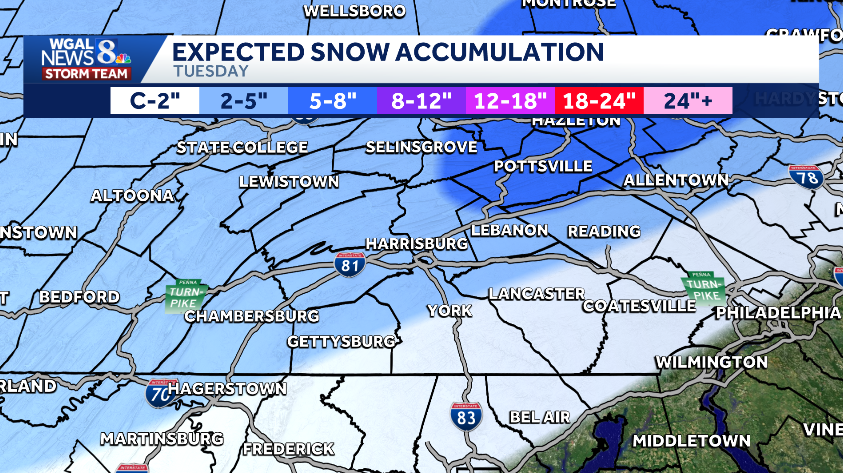
TOTALS
Rain will reduce snow totals in the southeastern counties, but higher elevations north and east of Harrisburg are still expected to see the greatest accumulations.
Lancaster, York and southeastern Adams counties: Coating to 2 inches, followed by rain
Most of the Susquehanna Valley: 2 to 5 inches of snow
Northern Dauphin, Lebanon, Schuylkill and Northumberland counties: Up to 5 inches of snow
CLOSINGS, DELAYS
There are already more than 300 closings and delays across the Susquehanna Valley.
Click here to view the full list.
TRAVEL IMPACTS
Morning Commute | Slow with reduced visibility and slick; Snow will be light to moderate but heavy, wet and slippery on roads
Afternoon and Evening Commute | Salt will be effective, leading to slushy and wet roads
Overnight to Wednesday Morning | Untreated wet spots may refreeze, creating icy patches; Watch for black ice
PennDOT has reduced the speed limits and set restrictions on nearly all major highways in the Susquehanna Valley. Click here to see what routes are impacted.
Did you capture a moment that you would like to share with News 8? Send us your photos or videos at https://www.wgal.com/upload.