A quick-hitting shot of winter weather arrived on schedule early Tuesday morning, making for some slick travel and snow-covered roads the first half of the day. Snow changed to rain from south to north as expected by afternoon before ending, as roads became more wet than snowy or icy and travel conditions improved.

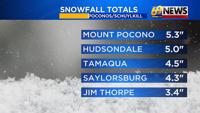
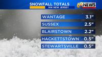
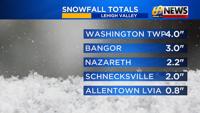
The final snow totals mirrored the forecast fairly well, with around a coating to an inch or two in the southern Lehigh Valley, only a coating at most south of there where it was mostly rain, three or four inches in the far northern Lehigh Valley, and three to six inches in the Poconos and in Schuylkill County.
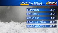
In Berks County, as much as two to four inches fell across far northern Berks, with only a coating in far southern and eastern Berks County.
As skies partially clear overnight and temperatures fall back below freezing, watch for a refreeze of any slush or water on untreated surfaces.
With plenty of sunshine and highs on Wednesday getting above freezing into the mid 30s, additional melting will take place, and road conditions will improve after some morning slick spots.