
Blustery Thursday, then record-challenging cold possible tonight in south-central Pennsylvania
High temperatures on Thursday will reach the upper 30s before dropping into the teens overnight Thursday and challenging record lows Friday morning. Temps remain below average this weekend while remaining dry. Next week we’re tracking an active pattern, allowing more chances for possible snow.
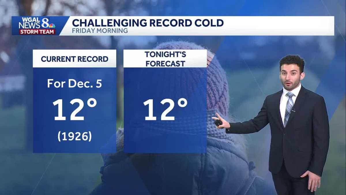
THANK YOU, THANK YOU. STAY HEALTHY. WASH YOUR HANDS A LOT. I THINK THE TAKEAWAY TO ALL RIGHT LET’S GET A CHECK ON THE FORECAST. IT IS GOING TO BE BITTERLY COLD RYAN. YES, ABSOLUTELY. ESPECIALLY GETTING INTO OVERNIGHT TONIGHT WHERE WE COULD BE SEEING SOME RECORD CHALLENGING LOW TEMPERATURES TO EVEN OR EVEN LIKE COLD TEMPERATURES TO START THE DAY AS WE GET INTO OUR FRIDAY. SO THAT’S WHY WE HAVE IT AS AN IMPACT NIGHT FOR TONIGHT FOR THOSE FRIGID DIGITS THAT WILL BE HITTING AS WE GET INTO THE THE END OF THE WEEK. NOW, GETTING INTO THE WEEKEND, IT’S GOING TO BE DRY, A LITTLE BIT GLOOMY AND COLD STILL INTO THE UPPER 30S. AND THEN LOOKING AHEAD INTO NEXT WEEK, WE ARE TRACKING A BIT OF AN UNSETTLED PATTERN TO TO GO THROUGH THE WEEK. SO FOR THE REST OF THIS EVENING, EXPECT MOSTLY CLEAR CONDITIONS WITH DIMINISHING WINDS OUT OF THE NORTHWEST. IT’S BREEZY RIGHT NOW. I’LL SAY DEFINITELY GUSTY, BUT THEY WILL BEGIN TO RELAX AS WE GET INTO LATER THIS EVENING. TEMPERATURES GETTING DOWN TO THE MID 20S FOR LATER THIS EVENING. THEN TONIGHT 8 TO 16 DEGREES IS OUR TEMPERATURE RANGE FOR OVERNIGHT. AND THAT’S WE HAVE IT AS AN IMPACT NIGHT FOR THE NEAR RECORD COLD TEMPERATURES. WE’LL HAVE LIGHTER WINDS OUT OF THE NORTHEAST AND WILL BE REMAINING MOSTLY CLEAR TOMORROW. PARTLY SUNNY, FRIGID, AND A FEW SNOW SHOWERS ARE POSSIBLE. ALTHOUGH THE SYSTEM THAT WE’RE WATCHING IS GOING TO BE STAYING MORE TOWARDS OUR SOUTH SO WE COULD SEE A FEW OR REALLY MORE. SO STRAY SNOW SHOWERS POSSIBLY. AS WE GET INTO TOMORROW, I’LL SHOW YOU THAT HERE IN THE PREDICTOR IN A FEW MINUTES, 28 TO 32 DEGREES FOR TOMORROW AFTERNOON. SO IF YOU’RE HEADED TO ANY OF THE CHRISTMAS TREE LIGHTING FOR THIS EVENING, SPRING GROVE EAST HANOVER TOWNSHIP MOSTLY CLEAR BREEZE RELAXES AND IT WILL BE FRIGID FOR LATER THIS EVENING. NOW, TEMPERATURES INTO THE 30S RIGHT NOW, ALTHOUGH THE WINDS RIGHT NOW THEY ARE KICKING OUT OF THE OUT OF THE NORTHWEST. YOU CAN SEE BETWEEN 15 AND 20MPH IN TERMS OF THE HIGHEST WIND SO FAR TODAY GUSTED TO 32 AT HARRISBURG, 29 IN LANCASTER, 26 IN YORK, LEBANON AND CARLISLE RIGHT INTO THE MID 30S. RANGE 35 AND 36MPH WITH GUSTS TO, AND YOU CAN SEE SUSTAINED WINDS BETWEEN THAT 15 TO 20 MILE PER HOUR RANGE ON AVERAGE. BUT WE’LL START TO SEE THOSE WINDS BEGIN TO SUBSIDE AS WE GET INTO LATER THIS EVENING. BUT UNTIL THAT HAPPENS, IT’S FEELING VERY COLD OUT THERE. IT FEELS LIKE 18 ALREADY IN LEWISTOWN, FEELS LIKE 26 IN CARLISLE, FEELING LIKE 26 IN THE RED ROSE CITY AT THIS TIME. AND HERE’S THE LOW TEMPERATURES FOR THE NEXT SEVERAL DAYS. AVERAGE FOR THIS TIME OF YEAR IS 31 DEGREES FOR THIS TIME OF THE YEAR, AND THEN 30 DEGREES BY NEXT WEDNESDAY. LOOK AT WHAT WE’RE FORECASTING FOR OVERNIGHT TONIGHT DOWN TO 12 DEGREES. HERE’S A LITTLE BIT OF A STATISTIC FOR YOU. THE CURRENT RECORD FOR DECEMBER 5TH IS 12 DEGREES. AND THAT WAS SET BACK IN 1926. YOU SEE THAT DETAIL THERE IN TERMS OF OVERNIGHT TONIGHT. HERE’S OUR FORECAST 12 DEGREES. WE ARE CHALLENGING THIS RECORD FROM DECEMBER 5TH 1926. WE’LL SEE HOW LOW WE GO. BUT IT’S IT’S IT’S GOING TO BE COLD OUT THERE. SO THAT’S WHY ONCE AGAIN IMPACT NIGHT FOR THE VERY COLD TEMPERATURES. MAKE SURE YOU BUNDLE UP AS WE HEAD INTO TONIGHT. THAT STARTS FROM 12 A.M. UNTIL 9 A.M. TOMORROW MORNING, BY THE WAY. BUT WE HAVE SOME A BRIEF AREA OF SOME HIGH PRESSURE HELPING TO CLEAR OUR SKIES. BUT YOU CAN SEE THE SYSTEM, THE DISTURBANCE TOWARDS OUR SOUTH. YOU SEE, IT’S REALLY JUST IT’S IT’S IT’S JUST TO THE SOUTH OF THE MASON-DIXON LINE. I’M NOT REALLY EXPECTING MUCH OF ANY ACTION AT ALL IN TERMS OF ANY SNOW CHANCES FOR TOMORROW. NOW, WE KEPT IT IN BECAUSE THERE MAY BE A THERE MAY BE AN INSTANCE WHERE WE SEE A STRAY LITTLE STRAY LITTLE SNOW SHOWER THAT MAY WORK ITS WAY NORTH, BUT OVERALL, THE ENTIRE SUSQUEHANNA VALLEY NOT REALLY SEEING MUCH OF A CHANCE OF SOME SNOW AS WE GET INTO FRIDAY. SO WE CALL IT STRAY FOR THE AFTERNOON, THEN GETTING INTO OUR SATURDAY, STILL LOOKING MOSTLY CLOUDY. WE DO HAVE A COLD FRONT THAT’S ON APPROACH, AND THAT’S WHAT’S GOING TO ALLOW SOME OF THOSE CLOUDS TO INCREASE AS WE HEAD INTO THE WEEKEND. SO YOU CAN SEE TEMPERATURES INTO THE 30S FOR THIS WEEKEND, BRISK AND COLD FOR MONDAY AND GETTING INTO TUESDAY, AND THEN LOOKING AHEAD INTO TUESDAY THROUGH FRIDAY OF NEXT WEEK, LOOKING AT AN UNSETTLED WEATHER PATTERN WITH SOME MORE RAIN AND SNOW CH
Blustery Thursday, then record-challenging cold possible tonight in south-central Pennsylvania
High temperatures on Thursday will reach the upper 30s before dropping into the teens overnight Thursday and challenging record lows Friday morning. Temps remain below average this weekend while remaining dry. Next week we’re tracking an active pattern, allowing more chances for possible snow.

Updated: 4:49 PM EST Dec 4, 2025
After an Arctic front made its way through the Valley this afternoon, temperatures are taking a plunge and reach the mid 20s later on, which is well below average for this time of the year. Winds have also picked up as the front passed overhead. Winds will relax later this evening as high pressure builds east.Low temps will approach record-challenging levels, in the upper teens for Thursday night, coming close to the record of 12 degrees set in 1926. Then Friday’s highs might not get out of the 20s in some areas!We’re watching a system that will slide to our south Friday evening through Friday night. It may produce flurries or light snow showers. However, the system will pass to our south, limiting how much snow we will see. Areas south of the PA Turnpike have the best chance of seeing some snowflakes. A light dusting is possible, but most areas will not see accumulation. If you are heading into the Baltimore or Washington, DC areas on Friday, be on the lookout for slick spots as minor accumulation in these areas is possible.Highs will be about 10 degrees below average this weekend, in the upper 30s. Look for a partly to mostly cloudy sky for Saturday & Sunday.Next week, unseasonably cold weather continues, as highs hover in the 30s. A series of clippers may bring snow showers on Tuesday into Wednesday, and a chance of rain/snow showers on Thursday.Have a great rest of your evening!
After an Arctic front made its way through the Valley this afternoon, temperatures are taking a plunge and reach the mid 20s later on, which is well below average for this time of the year. Winds have also picked up as the front passed overhead. Winds will relax later this evening as high pressure builds east.
Low temps will approach record-challenging levels, in the upper teens for Thursday night, coming close to the record of 12 degrees set in 1926. Then Friday’s highs might not get out of the 20s in some areas!
We’re watching a system that will slide to our south Friday evening through Friday night. It may produce flurries or light snow showers. However, the system will pass to our south, limiting how much snow we will see. Areas south of the PA Turnpike have the best chance of seeing some snowflakes. A light dusting is possible, but most areas will not see accumulation. If you are heading into the Baltimore or Washington, DC areas on Friday, be on the lookout for slick spots as minor accumulation in these areas is possible.
Highs will be about 10 degrees below average this weekend, in the upper 30s. Look for a partly to mostly cloudy sky for Saturday & Sunday.
Next week, unseasonably cold weather continues, as highs hover in the 30s. A series of clippers may bring snow showers on Tuesday into Wednesday, and a chance of rain/snow showers on Thursday.
Have a great rest of your evening!