
It’ll be a chilly & dry weekend across the Susquehanna Valley. Temperatures will still be below average. Skies have partially cleared in some areas this evening, but remain mostly cloudy overall. Temps are down into the 30s.Clouds return overnight, remaining mostly cloudy, and low temperatures will bottom out in the upper 20s range. Winds will be calmIMPACT DAY SUNDAYAn Air Quality Alert has been issued for Lancaster, York, Dauphin, Cumberland, Lebanon counties until Monday Dec 08 at 12 AM by the Pennsylvania Department of Environmental Protection. The low levels of the current air mass that is overhead has become stagnant, therefore this stale air will reduce air quality across portions of our area, making the air unhealthy for sensitive groups. Kids, elderly, and individuals with lung/heart complications should reduce any strenuous outdoor activity for tomorrow. Sunday, there will be more clouds than sun. Highs are in the upper 30s to near 40 degrees. A few flurries later in the day as a cold front comes through are possible. Once the cold front moves across the area, air quality will begin to improve.Behind the front comes another rush of colder air for Monday. In fact, highs will take place in the low 30s after midnight, then temperatures will fall to the upper 20s by morning and only recover to near 30° for the afternoon. However, gusty winds will make it feel like the teens and 20s much of the day. Skies will be partly sunny.Tuesday, lows are in the teens and with plenty of cloud cover, temperatures only climb to the low 30s. A weak clipper may bring some light snow flurries.A more potent clipper diving into the area Wednesday will bring a better chance for rain and/or snow showers. Highs are the warmest of the week, around 40 degrees.The pattern remains unsettled with several clippers bringing the chance for snow flurries or snow showers. The main story is the below average chill remains throughout next weekend.Have a great rest of your evening!~ Ryan
It’ll be a chilly & dry weekend across the Susquehanna Valley. Temperatures will still be below average. Skies have partially cleared in some areas this evening, but remain mostly cloudy overall. Temps are down into the 30s.
Clouds return overnight, remaining mostly cloudy, and low temperatures will bottom out in the upper 20s range. Winds will be calm
IMPACT DAY SUNDAY
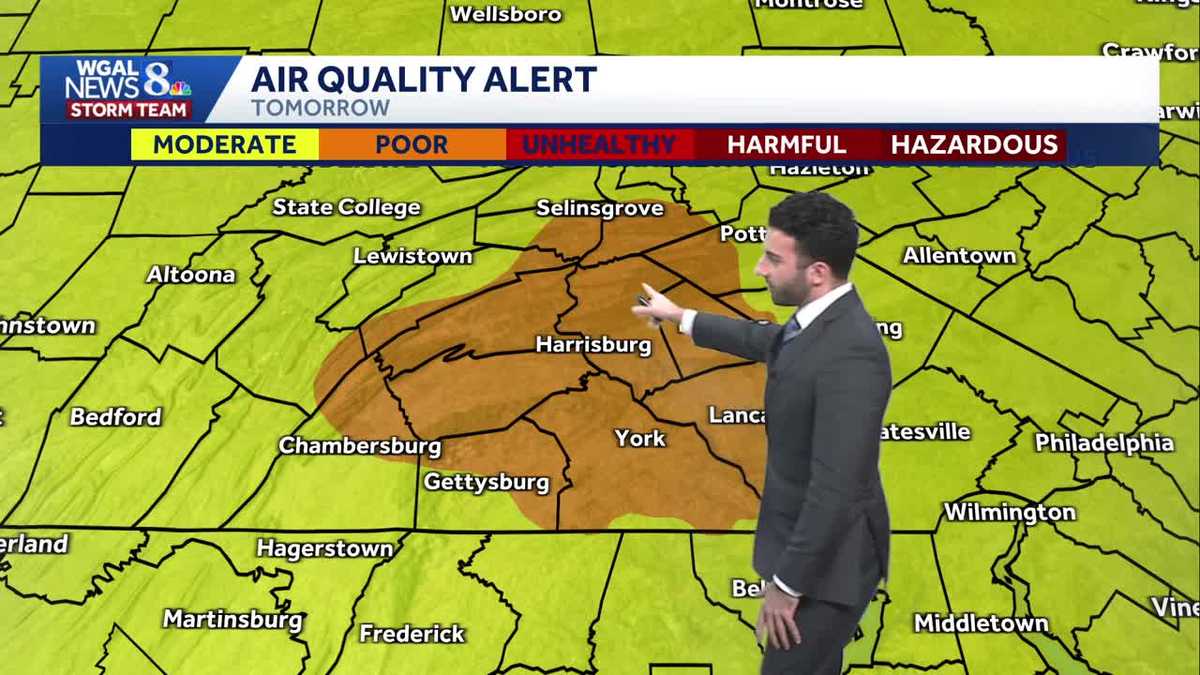
An Air Quality Alert has been issued for Lancaster, York, Dauphin, Cumberland, Lebanon counties until Monday Dec 08 at 12 AM by the Pennsylvania Department of Environmental Protection. The low levels of the current air mass that is overhead has become stagnant, therefore this stale air will reduce air quality across portions of our area, making the air unhealthy for sensitive groups. Kids, elderly, and individuals with lung/heart complications should reduce any strenuous outdoor activity for tomorrow.
Sunday, there will be more clouds than sun. Highs are in the upper 30s to near 40 degrees. A few flurries later in the day as a cold front comes through are possible. Once the cold front moves across the area, air quality will begin to improve.
Behind the front comes another rush of colder air for Monday. In fact, highs will take place in the low 30s after midnight, then temperatures will fall to the upper 20s by morning and only recover to near 30° for the afternoon. However, gusty winds will make it feel like the teens and 20s much of the day. Skies will be partly sunny.
Tuesday, lows are in the teens and with plenty of cloud cover, temperatures only climb to the low 30s. A weak clipper may bring some light snow flurries.
A more potent clipper diving into the area Wednesday will bring a better chance for rain and/or snow showers. Highs are the warmest of the week, around 40 degrees.
The pattern remains unsettled with several clippers bringing the chance for snow flurries or snow showers. The main story is the below average chill remains throughout next weekend.
Have a great rest of your evening!
~ Ryan