
Western PA: PM flakes north, more snow/rain mid-week
The mid-week system will have a wider reach across all of western PA.
IT’S DOWN IN BALTIMORE OF COURSE THIS AFTERNOON. AND WE’RE GOING TO KEEP THAT WINTER WEATHER GOING HERE FOR THIS FIRST WEEK OF DECEMBER. TEMPERATURES SEASONABLY CHILLY WILL BE ANYWHERE FROM THE UPPER 20S. YES, ALL DAY IN THE 20S. COMING UP TOMORROW ON OUR WAY TO ABOUT 40 DEGREES ON WEDNESDAY. THAT IS A DAY TO KEEP AN EYE ON, AS WE WILL SEE A BRIEF PERIOD OF SOME WET SNOW CHANGING OVER TO RAIN. IT DOES LOOK LIKE MOST OF WEDNESDAY’S SYSTEM IS GOING TO COME AS RAIN BEFORE EVENTUALLY SOME COLDER AIR AND SNOWFLAKES CATCH UP ON THE TAIL END, BUT NOT MUCH TO SEE OUTSIDE THE CLOUDS. AND ALSO, OF COURSE, THE PRETTY LIGHTS OVER THE CITY OF PITTSBURGH WITH ACTION CAM HERE AS YOU’RE WAKING UP ON A SUNDAY MORNING, DOESN’T FEEL TOO BAD AS TEMPERATURES ARE RIGHT AROUND 30 IN MOST NEIGHBORHOODS IN THE 30S. WE WILL STAY AS WE GET ANOTHER DOSE OF GRAY SKIES. CHILLY TEMPERATURES 36. OUR FORECAST HIGH FOR PITTSBURGH. WE WILL SEE A FEW FLURRIES SHOWING UP NORTH OF TOWN AS WE WORK THROUGH THE AFTERNOON. I’LL PINPOINT THAT HERE IN JUST A MOMENT. HERE’S THAT COLDER DAY MONDAY, BUT DOES COME WITH SOME SUNSHINE. A HIGH OF ONLY 27 BACK INTO THE 30S, EVEN PUSHING TOWARDS 40 BY WEDNESDAY. AGAIN, THAT’S THE DAY THAT WE’RE KIND OF CIRCLING IN YOUR 4-DAY PLUS 4 MORE FORECAST FOR EVENTUALLY, EVEN MORE COLD AIR RUSHES IN AS WE’RE JUST STUCK IN THAT PATTERN HERE FOR THESE EARLY TO EVEN MID DAYS OF DECEMBER. AGAIN, YOU CAN SEE ALL THE CLOUDS ON FUTURECAST. THAT’S HOW MOST OF THE DAY IS GOING TO PLAY OUT. REALLY NO ISSUES. IF YOU’RE OFF TO CHURCH THIS MORNING, MAYBE GETTING EARLY RUN AT THE GROCERY STORE OR JUST RUNNING AROUND HERE ON A SUNDAY BEFORE THE STEELERS GAME, 1:00 AS EARLY AS NOON. FOR THOSE OF YOU IN VENANGO AND MERCER COUNTIES, WE WILL SEE SOME OF THOSE SNOWFLAKES SHOWING UP. THIS IS A CLIPPER SYSTEM. TYPICALLY THEY’RE FAST MOVING, DON’T REALLY DO A WHOLE LOT WHEN IT COMES TO ACCUMULATION. THAT CERTAINLY IS GOING TO BE THE CASE AS WE WORK THROUGH THIS AFTERNOON. COULD SEE SOME OF THAT SNOW SHOWER ACTIVITY SHOWING UP FOR AREAS LIKE CLARION, KITTANNING, CERTAINLY SOUTHERN PARTS OF BUTLER COUNTY, EVEN EXTENDING BACK TOWARDS BEAVER AS YOU APPROACH DINNER TIME. BUT THEN EVERYTHING JUST BEGINS TO FALL APART AS IT MOVES INTO ALLEGHENY COUNTY. THOSE AREAS FARTHER TO THE SOUTH. SO FOR THE MOST PART, WE ARE GOING TO MISS OUT ON THIS ROUND OF SNOW. BUT A LITTLE BIT MORE ACTIVITY IS COMING IN TOWARDS THE MIDDLE PART OF THE WEEK. LATE TONIGHT THOSE CLOUDS WILL BREAK. STARTING OFF VERY COLD IN THE MORNING AND OF COURSE STAYING IN THE 20S AS WE GO THROUGH YOUR MONDAY. BUT AT LEAST WE GET THAT DOSE OF SUNSHINE AS WE KICK OFF A BRAND NEW WEEK. LET’S FAST FORWARD INTO WEDNESDAY AGAIN. THE DAY THAT WE’VE BEEN TALKING ABOUT FOR A LITTLE WHILE, AS WE COULD SEE A BRIEF PERIOD OF SOME WET SNOWFLAKES IN THE MORNING BEFORE WE CHANGE OVER TO ALL RAIN. MY BIG CONCERN IS WHAT COMES IN TOWARDS THE EVENING DRIVE, AS WE WILL SEE SOME COLDER AIR SHOWING UP THAT COULD LEAD TO THE CHANGEOVER BACK TO SNOW. THE EXACT TIMING OF THAT IS STILL A QUESTION MARK, SO WE’LL KEEP THE IMPACT DAY AWAY, BUT STILL AGAIN COULD SEE SOME IMPACTS LATER ON THE EVENING. ON WEDNESDAYS, THAT CHILLIER AIR SHOWS BACK UP FROM 36 TODAY TO JUST 27 ON MONDAY, AGAIN WORKING TOWARDS THE LOWER 40S WITH A MESSIER AND WETTER SETUP ON WEDNESDAY. THE REST OF YOUR 4-DAY PLUS 4 MORE FORECAST FLURRIES WILL LINGER ON THURSDAY, WITH A HIGH OF 35. TEMPERATURES CONTINUE TO SLIDE. IN FACT, WE’RE ONLY GOING TO BE IN THE 20S AS WE APPROACH NEXT WEEKEND, BUT WE SHOULD BE DRY AS WE LOOK TOWARDS THE FIRST NIGHT OF HANUKKAH NEXT SUNDAY. LOTS OF RUNNING AROUND TOO, AS THE LATER HOLIDAY SEASON REALLY RAMPS UP HERE AS WELL. ABSOLUTELY. HONESTLY, I WAS THINKING JUST BECAUSE OF ALL THE SNOW WE HAD THIS PAST TUESDAY. DEFINITELY A NICE LITTLE SWITCH UP, NICE LITTLE BREAK TO GIVE US. OF COURSE, COLD WEATHER IS NOT GOING ANYWHERE, BUT I’LL DEFINITELY TAKE IT. YEAH, THE SNOW THAT WE SEE THIS
Western PA: PM flakes north, more snow/rain mid-week
The mid-week system will have a wider reach across all of western PA.

Updated: 7:46 AM EST Dec 7, 2025
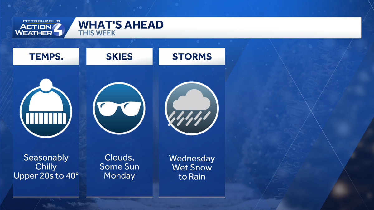
It’s another gray and chilly day for the Pittsburgh area. A few flurries will show up this afternoon with the best chances to the north of US-422. We are tracking another system with area-wide impacts for the middle of the upcoming week.A few afternoon flurries followed by colder airClouds will hang touch for western PA to wrap up this first weekend of December. Temperatures will peak in the mid 30s. A weak clipper with keep the clouds in tact with flurry chance this afternoon. Areas near the I-80 corridor could see flakes as early as lunchtime with a coating of fresh snow possible. The flurry activity fizzles as it drops closer to Allegheny County. The flakes end by 7 p.m.A colder air mass arrives on the heals of this system. Temperatures will be stuck in the 20s all day long Monday. Despite the cold air, we will get a dose of sunshine! Tracking a larger system mid-weekClouds will return with another round of flurries north of Pittsburgh on Tuesday. We are watching a larger winter system that will impact our area. Wet snowflakes are possible Wednesday morning before warmer air surges in and the snow quickly transitions to rain. Rain will be the primary precipitation type of this storm. The tail end could feature a little more snow. There are still questions about the arrival time of the cold air. This changeover could impact the evening drive.An extended cold spellBehind the mid-week system, temperatures will slide through 30s and possible into the 20s by next weekend. The long range outlook favors below average temperatures for western PA through the first day of winter.TODAY: Cloudy and chilly with afternoon flurries north. High: 36°.TONIGHT: Mostly cloudy, low: 20°.MONDAY: Colder despite partly cloudy skies. High: 27°, low: 15°.TUESDAY: Clouds return with flurries north. High: 34°, low: 33°.WEDNESDAY: Morning flakes transition to rain. High: 41°, low: 29°.
PITTSBURGH —
It’s another gray and chilly day for the Pittsburgh area. A few flurries will show up this afternoon with the best chances to the north of US-422. We are tracking another system with area-wide impacts for the middle of the upcoming week.
A few afternoon flurries followed by colder air
Clouds will hang touch for western PA to wrap up this first weekend of December. Temperatures will peak in the mid 30s. A weak clipper with keep the clouds in tact with flurry chance this afternoon. Areas near the I-80 corridor could see flakes as early as lunchtime with a coating of fresh snow possible. The flurry activity fizzles as it drops closer to Allegheny County. The flakes end by 7 p.m.

Hearst OwnedHearst
Snow and a fresh coating will be limited to areas well north of Allegheny County.
A colder air mass arrives on the heals of this system. Temperatures will be stuck in the 20s all day long Monday. Despite the cold air, we will get a dose of sunshine!

Hearst OwnedHearst
Don’t be deceived by the sunshine Monday. It will be a colder air with highs only in the 20s.
Tracking a larger system mid-week
Clouds will return with another round of flurries north of Pittsburgh on Tuesday. We are watching a larger winter system that will impact our area.

Hearst OwnedHearst
All of western PA will see periods of wet snow and rain on Wednesday.
Wet snowflakes are possible Wednesday morning before warmer air surges in and the snow quickly transitions to rain. Rain will be the primary precipitation type of this storm. The tail end could feature a little more snow. There are still questions about the arrival time of the cold air. This changeover could impact the evening drive.
An extended cold spell
Behind the mid-week system, temperatures will slide through 30s and possible into the 20s by next weekend. The long range outlook favors below average temperatures for western PA through the first day of winter.

Hearst OwnedHearst
A quieter but colder second half of the upcoming week.
TODAY: Cloudy and chilly with afternoon flurries north. High: 36°.
TONIGHT: Mostly cloudy, low: 20°.
MONDAY: Colder despite partly cloudy skies. High: 27°, low: 15°.
TUESDAY: Clouds return with flurries north. High: 34°, low: 33°.
WEDNESDAY: Morning flakes transition to rain. High: 41°, low: 29°.