
Western PA: PM flakes north, more snow/rain mid-week
The mid-week system will have a wider reach across all of western PA.
SPORTS SUCH AN INTERESTING GAME AHEAD. OF COURSE. HUGE IMPLICATIONS MOVING FORWARD. REGARDLESS OF WHO WINS THIS GAME. BUT ALSO SOMETHING INTERESTING IS HAPPENING ON THE WEATHER FRONT THROUGHOUT THE WEEK. A LOT OF BACK AND FORTH HAPPENING HERE, RIGHT? WE’VE REALLY SET THE STAGE FOR THIS BIG AFC NORTH MATCHUP TODAY, BOTH IN THE FORECAST HERE IN PITTSBURGH AND ALSO DOWN IN BALTIMORE. AND THAT LITTLE VARIETY FOR US AT HOME WILL COME WITH OUR TEMPERATURES. BUT ALSO WHAT FALLS FROM THE SKY TODAY A FEW FLURRIES WILL BE POSSIBLE ESPECIALLY NORTH OF TOWN. THIS IS OUR FUTURE SNOW AND NOT REALLY A LOT OF SNOW COMING OUR WAY, BUT ALSO GOOD INDICATION OF WHO MAY SEE SOME FLAKES AND WHO WON’T. THIS SYSTEM REALLY RUNNING OUT OF STEAM AS WE CONTINUE THROUGH THE AFTERNOON AS IT SWINGS THROUGH WESTERN PENNSYLVANIA. SO WE MAY SEE A FEW OF THOSE FLAKES SHOWING UP UP ALONG 422, CERTAINLY I-80. BUT BY THE TIME IT REACHES THE CITY, EVERYTHING KIND OF STOPS AND FIZZLES OUT. BUT ONCE THAT SYSTEM CLEARS US, WE OPEN THE DOOR TO ANOTHER LAYER OF COLD AIR. TEMPERATURES WILL BE TRAPPED IN THE 20S ALL DAY LONG TOMORROW. BUT THE GOOD NEWS I KNOW. HARD TO SWALLOW. SOME COLD TEMPERATURES WILL BE SOME SUNSHINE. THEY’LL BE COMING IN THROUGHOUT THE COURSE OF THE DAY. SO NOT EXACTLY A FAIR TRADE OFF, BUT WE’LL TAKE THE SUNSHINE EVEN ON A COLDER DAY. HIGHS WILL BE IN THE 20S FOR MOST NEIGHBORHOODS ACROSS WESTERN PENNSYLVANIA, BUT THAT CHILL IS SHORT LIVED. TEMPERATURES START TO WARM BACK UP. IN FACT, A MILDER DAY COME WEDNESDAY. THAT’S THE NEXT DAY THAT WE’RE REALLY KEEPING A CLOSE EYE ON WITH A BIGGER STORM SYSTEM THAT WILL BRING SOME PERIODS OF WET SNOW AND EVENTUALLY RAIN CHANCES INTO THE AFTERNOON. I’LL PINPOINT THAT HERE IN JUST A MOMENT. WE’VE GOT SOME NEW DATA IN WITH FUTURECAST. LET’S WALK THROUGH IT HOUR BY HOUR. YOU CAN SEE THOSE CLOUDY SKIES STICKING AROUND THROUGH THE LUNCH HOUR AND EVEN BEYOND. HERE’S THIS CLIPPER SYSTEM THAT’S GOING BE DROPPING IN LATE THIS AFTERNOON REALLY BREAKS DOWN AS WE HEAD THROUGH THE SECOND HALF OF THE DAY AGAIN, MAYBE SOME SNOW SHOWERS UP ALONG I-80. 422 CORRIDOR, BUT BEYOND THAT, FLURRIES ARE BASICALLY OUT OF THE PICTURE AND THINGS WILL BE QUIETING DOWN AS WE GO THROUGH THE OVERNIGHT. CLOUDS WILL BREAK THAT WILL ALLOW FOR THAT COLDER AIR TO SETTLE IN. SO TEMPERATURES START OFF TEENS TO AROUND 20, AND THEN WE DON’T WARM MUCH THROUGHOUT THE DAY. DESPITE THE SUNSHINE ON MONDAY, STILL, A FAST PACED STORM TRACK AS WE’LL SEE ANOTHER SYSTEM MOVING IN ON WEDNESDAY. COLD ENOUGH, AT LEAST AT THE ONSET, FOR SOME WET SNOWFLAKES. BUT WARMER AIR IS TAKING OVER QUICKLY, SO AS WE SURGE INTO THE 40S, WE’LL INTRODUCE THOSE RAIN CHANCES. IT’S THE TAIL END THAT I’M A LITTLE BIT MORE CONCERNED ABOUT AS THE COLD AIR ARRIVES A LITTLE BIT SOONER, WE COULD BE TALKING ABOUT THE CHANGEOVER TO SNOW DURING THE EVENING COMMUTE. THAT’S CERTAINLY SOMETHING WE’LL BE MONITORING AS WE GO OVER THE NEXT TWO DAYS, BUT AT THIS POINT, VERY LITTLE ADDITIONAL ACCUMULATION IS EXPECTED. BUT FOR NOW, WE’RE STUCK WITH THE CLOUDS. A LITTLE BIT OF A CHILL IN THE AIR. 31 OUR CURRENT TEMPERATURE PITTSBURGH INTERNATIONAL ONLY CLIMBING TO 36 TOWARDS THE SECOND HALF OF THE DAY. 27 FOR YOUR MONDAY. BUT THEN WE START TO BUILD THOSE TEMPERATURES BACK UP WEDNESDAY. THE WETTEST DAY, BUT THE MILDEST DAY AS WELL. 41 FOR A HIGH ON THE BACK END OF THAT MIDWEEK SYSTEM, TEMPERATURES WILL FALL BACK INTO THE 30S WITH STILL SOME LINGERING FLURRIES ON THURSDAY GETTING EVEN COLDER STILL AS WE APPROACH NEXT WEEKEND. BUT WE’LL HOPEFULLY KEEP THINGS DRY AS OF COURSE, WE WANT TO TAKE PART IN ALL THOSE FESTIVE EVENTS. DO SOME RUNNING AROUND, SOME SHOPPING AS WE GET SET. ALSO, FOR THE FIRST NIGHT OF HANUKKAH NEXT SUNDAY, WITH ALL THE UPS AND DOWNS THROUGHOUT THE WEEK, I REALLY THINK, AND I DON’T KNOW IF YOU CAN AGREE WITH ME HERE, THAT THIS COULD BE A REALLY GOOD DAY TO GET THE HOLIDAY DECORATIONS OUT. AS WE PREPARE FOR WHAT’S AHEAD, RIGHT? EXACTLY. SINCE SOME OF THE SNOW IS ALSO STARTING TO MELT TOO, SO MAYBE IT’S A LITTLE BIT EASIER TO STRING THE LIGHTS AND ALSO GET THE BLOWUPS READY TO GO
Western PA: PM flakes north, more snow/rain mid-week
The mid-week system will have a wider reach across all of western PA.

Updated: 10:17 AM EST Dec 7, 2025
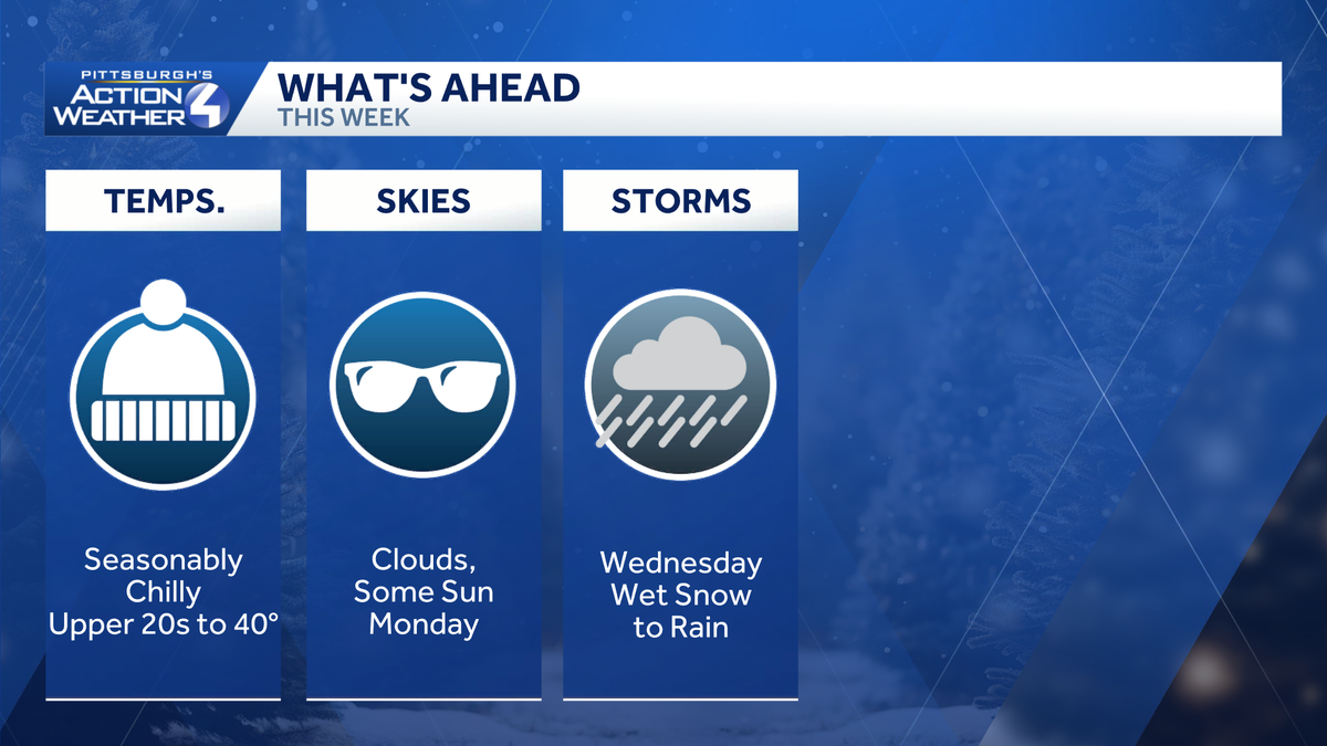
It’s another gray and chilly day for the Pittsburgh area. A few flurries will show up this afternoon with the best chances to the north of US-422. We are tracking another system with area-wide impacts for the middle of the upcoming week.A few afternoon flurries followed by colder airClouds will hang touch for western PA to wrap up this first weekend of December. Temperatures will peak in the mid 30s. A weak clipper with keep the clouds in tact with flurry chance this afternoon. Areas near the I-80 corridor could see flakes as early as lunchtime with a coating of fresh snow possible. The flurry activity fizzles as it drops closer to Allegheny County. The flakes end by 7 p.m.A colder air mass arrives on the heals of this system. Temperatures will be stuck in the 20s all day long Monday. Despite the cold air, we will get a dose of sunshine! Tracking a larger system mid-weekClouds will return with another round of flurries north of Pittsburgh on Tuesday. We are watching a larger winter system that will impact our area. Wet snowflakes are possible Wednesday morning before warmer air surges in and the snow quickly transitions to rain. Rain will be the primary precipitation type of this storm. The tail end could feature a little more snow. There are still questions about the arrival time of the cold air. This changeover could impact the evening drive.An extended cold spellBehind the mid-week system, temperatures will slide through 30s and possible into the 20s by next weekend. The long range outlook favors below average temperatures for western PA through the first day of winter.TODAY: Cloudy and chilly with afternoon flurries north. High: 36°.TONIGHT: Mostly cloudy, low: 20°.MONDAY: Colder despite partly cloudy skies. High: 27°, low: 15°.TUESDAY: Clouds return with flurries north. High: 34°, low: 33°.WEDNESDAY: Morning flakes transition to rain. High: 41°, low: 29°.
PITTSBURGH —
It’s another gray and chilly day for the Pittsburgh area. A few flurries will show up this afternoon with the best chances to the north of US-422. We are tracking another system with area-wide impacts for the middle of the upcoming week.
A few afternoon flurries followed by colder air
Clouds will hang touch for western PA to wrap up this first weekend of December. Temperatures will peak in the mid 30s. A weak clipper with keep the clouds in tact with flurry chance this afternoon. Areas near the I-80 corridor could see flakes as early as lunchtime with a coating of fresh snow possible. The flurry activity fizzles as it drops closer to Allegheny County. The flakes end by 7 p.m.

Hearst OwnedHearst
Snow and a fresh coating will be limited to areas well north of Allegheny County.
A colder air mass arrives on the heals of this system. Temperatures will be stuck in the 20s all day long Monday. Despite the cold air, we will get a dose of sunshine!

Hearst OwnedHearst
Don’t be deceived by the sunshine Monday. It will be a colder air with highs only in the 20s.
Tracking a larger system mid-week
Clouds will return with another round of flurries north of Pittsburgh on Tuesday. We are watching a larger winter system that will impact our area.

Hearst OwnedHearst
All of western PA will see periods of wet snow and rain on Wednesday.
Wet snowflakes are possible Wednesday morning before warmer air surges in and the snow quickly transitions to rain. Rain will be the primary precipitation type of this storm. The tail end could feature a little more snow. There are still questions about the arrival time of the cold air. This changeover could impact the evening drive.
An extended cold spell
Behind the mid-week system, temperatures will slide through 30s and possible into the 20s by next weekend. The long range outlook favors below average temperatures for western PA through the first day of winter.

Hearst OwnedHearst
A quieter but colder second half of the upcoming week.
TODAY: Cloudy and chilly with afternoon flurries north. High: 36°.
TONIGHT: Mostly cloudy, low: 20°.
MONDAY: Colder despite partly cloudy skies. High: 27°, low: 15°.
TUESDAY: Clouds return with flurries north. High: 34°, low: 33°.
WEDNESDAY: Morning flakes transition to rain. High: 41°, low: 29°.