
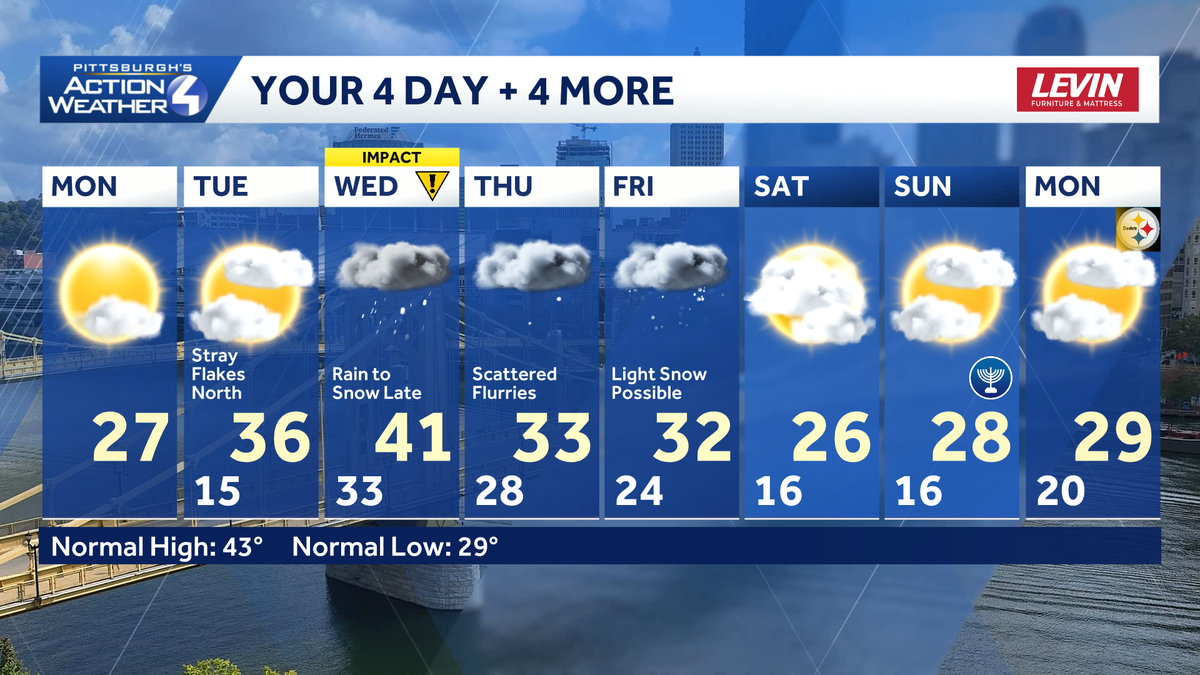
The winter pattern lives on for another week with seasonably cold temperatures and bursts of wintry weather for western Pennsylvania. We are tracking another system with rain chance mid-week, prompting an Impact Day for Wednesday.Colder but brighter todayA fresh batch of Arctic air settled behind yesterday’s flurry activity. We are waking up to feels like temperatures in the teens. Air temperatures will be stuck in the 20s all day long. On the bright side, the colder feeling will come with a dose of sunshine today.The colder air push will be short lived as a southwest flow through mid-week will bring temperatures back into the upper 30s and lower 40s.A weak system will skirt us to the north tomorrow. For the most part, our area will see increasing clouds with a few flurries north, especially near I-80 Tuesday afternoon. High temperatures will crack the freezing mark. Impact Day Wednesday for rain changing to late-day snowWe are watching a larger system impacting the entire area on Wednesday, prompting a new Impact Day. Precipitation will be more a nuisance, but the timing of this system could effect travel.Wet snowflakes are possible at the onset Wednesday morning north of Route 422. Warmer air quickly surges in pushing temperatures into the 40s. Rain showers will be the primary precipitation type for the area through Wednesday afternoon. The tail end could feature a few leftover flurries by late-day. The transition back to snow could impact the evening commute. Occasional flurries and a winter chillBehind the mid-week system, temperatures will slide back into the 30s Thursday and Friday, then drop again into the 20s by the weekend. Occasional flurries will be develop Thursday followed by the potential for a little more light snow on Friday. The long range outlook favors below average temperatures for western PA through the first day of winter.TODAY: Colder with sunshine at times. High: 27°.TONIGHT: Partly cloudy and cold. Low: 15°.TUESDAY: Increasing clouds with stray flurries north. Breezy and not as cold. High: 36°, low: 33°.WEDNESDAY – Impact Day: Brief period of wet snow, then rain. Changing back to snow late-day. High: 41°, low: 28°.THURSDAY: Scattered flurries. High: 33°, low: 24°.
PITTSBURGH —
The winter pattern lives on for another week with seasonably cold temperatures and bursts of wintry weather for western Pennsylvania. We are tracking another system with rain chance mid-week, prompting an Impact Day for Wednesday.
Colder but brighter today
A fresh batch of Arctic air settled behind yesterday’s flurry activity. We are waking up to feels like temperatures in the teens. Air temperatures will be stuck in the 20s all day long. On the bright side, the colder feeling will come with a dose of sunshine today.

Hearst OwnedHearst
You’ll need your heavy coat, winter accessories, and sunglasses today.
The colder air push will be short lived as a southwest flow through mid-week will bring temperatures back into the upper 30s and lower 40s.
A weak system will skirt us to the north tomorrow. For the most part, our area will see increasing clouds with a few flurries north, especially near I-80 Tuesday afternoon. High temperatures will crack the freezing mark.
Impact Day Wednesday for rain changing to late-day snow
We are watching a larger system impacting the entire area on Wednesday, prompting a new Impact Day. Precipitation will be more a nuisance, but the timing of this system could effect travel.

Hearst OwnedHearst
Wednesday is now an Impact Day for wet snow quickly changing to rain, then ending as more snow by the evening.
Wet snowflakes are possible at the onset Wednesday morning north of Route 422. Warmer air quickly surges in pushing temperatures into the 40s. Rain showers will be the primary precipitation type for the area through Wednesday afternoon. The tail end could feature a few leftover flurries by late-day. The transition back to snow could impact the evening commute.

Hearst OwnedHearst
Messy commutes – especially the evening drive – are possible with changing precipitation types on Wednesday.
Occasional flurries and a winter chill
Behind the mid-week system, temperatures will slide back into the 30s Thursday and Friday, then drop again into the 20s by the weekend. Occasional flurries will be develop Thursday followed by the potential for a little more light snow on Friday. The long range outlook favors below average temperatures for western PA through the first day of winter.

Hearst OwnedHearst
Trending colder for the Pittsburgh area following Wednesday’s Impact Day.
TODAY: Colder with sunshine at times. High: 27°.
TONIGHT: Partly cloudy and cold. Low: 15°.
TUESDAY: Increasing clouds with stray flurries north. Breezy and not as cold. High: 36°, low: 33°.
WEDNESDAY – Impact Day: Brief period of wet snow, then rain. Changing back to snow late-day. High: 41°, low: 28°.
THURSDAY: Scattered flurries. High: 33°, low: 24°.