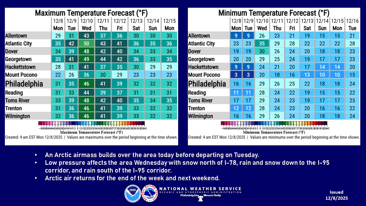
A severe Arctic air mass is set to plunge the Lehigh Valley region into dangerously cold conditions overnight Monday into Tuesday, with temperatures potentially approaching record low levels.
Residents should prepare for single-digit temperatures and wind chills that could make being outdoors extremely hazardous.
The National Weather Service forecast indicates temperatures will drop dramatically after a cold front passes through the region Monday morning. Low temperatures overnight are expected to range from single digits in higher terrain to low teens elsewhere, with wind chills making it feel even colder. The Lehigh Valley and Pocono regions are expected to experience the most extreme cold, with some areas potentially coming within a few degrees of record low temperatures for the Dec. 9 date.
At Lehigh Valley International Airport, a low of 8 degrees is forecast early Tuesday morning — challenging the record low of 7 set in 2002, according to the weather service.
 As single-digit temperatures forecast early Tuesday, Dec. 9, 2025, in the Lehigh Valley threaten to approach record low set in 2002, experts advise protecting pipes, checking on vulnerable neighbors, and taking these other essential precautions.National Weather Service
Wednesday will bring a slight moderation in temperatures, with highs reaching the low 40s and a chance of mixed precipitation. A wintry mix is possible, with snow likely in the southern Poconos and other northern areas of the region, potentially changing to rain as temperatures rise. Accumulations are forecast to be light, generally 1 to 2 inches in higher elevations.
The cold pattern continues through the end of the week, with multiple reinforcing cold fronts pushing through the region. Weekend temperatures will struggle to reach freezing, with highs in the low to mid-30s. Saturday and Sunday are expected to remain bitterly cold, with lows dropping into the teens and low 20s.
Residents are advised to take precautions against the extreme cold, including protecting pipes, checking on vulnerable individuals and pets, and dressing in layers when going outdoors. The dangerous cold is expected to persist through midweek before a slight warming trend begins.
Current weather radar