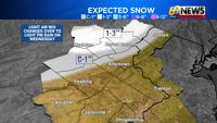
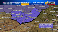
Lots of cold, and a little snow; those are the main weather themes so far this December, and there’s no end in sight. We’re tracking a fast-moving clipper system that will deliver a light mix of rain and snow on Wednesday across the area, though accumulations (of 1″ or more) will be limited to the Poconos.
For the Poconos, it’s mostly some occasional light snow Wednesday, though a little mixing is possible before the end of the day. Across Carbon, Monroe, Pike, and Luzerne counties, 1-3 inches of snow is possible, with the highest amounts above 1500 feet in elevation.
Along and north of the I-78 corridor, through northern Berks County, the Lehigh Valley, the Slate Belt, and Warren County in New Jersey, some light snow from late morning to early afternoon will change to light rain during the afternoon. Accumulations of a coating to less than an inch of snow are possible, especially north of I-78 and closer to Blue Mountain.
Farther south of I-78, it’s mostly light rain, with perhaps a little wet snow mixed in initially but with no accumulation.
As temps rise above freezing to 35-40° in the afternoon, roads will mostly be wet outside of the Poconos. However, some slick travel can be expected through the Poconos, where the winter weather will linger longest.

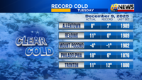
An arctic blast delivered bitter cold single digit lows for many early Tuesday morning, including a record low of -4° in Mount Pocono. Allentown just missed the record low of 7° by one degree, but the Lehigh Valley is off to a Top 10 coldest start to December through the first 9 days of the month.
There’s no warmup in sight, with more arctic air arriving Sunday, and perhaps the better chance of some area-wide light snow Saturday night into Sunday morning.
Stay updated with the latest weather developments at 69 News weather forecast page.