
Windy & cold this evening, chills in the teens; tracking more snow chances in south-central Pennsylvania
It’s been a bitterly cold day across the Valley with wind chills in the low 20s and teens! We’re tracking more snow chances heading into the weekend.
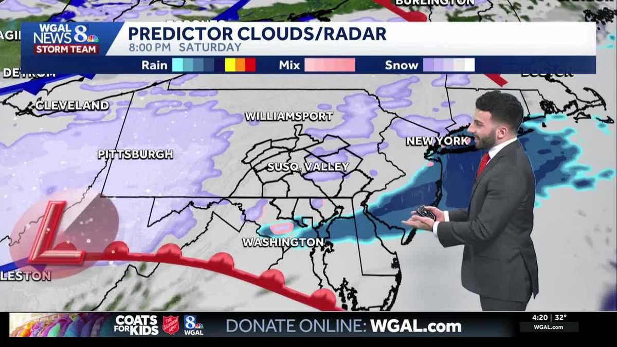
THAT. LET’S DO IT BECAUSE IT’S COLD AND BLUSTERY OUT THERE RIGHT NOW. SEEING SOME LIGHT SNOW EVEN IN SOME OF OUR NORTHWESTERN COMMUNITIES, ESPECIALLY TOWARDS MIFFLIN AND JUNIATA COUNTIES AT THIS TIME, THEY ARE BEGINNING TO KIND OF RELAX OR BEGINNING TO TO TAPER AS THEY CONTINUE TO MAKE THEIR WAY SOUTHEAST. BUT JUST SEEING SOME LIGHT SNOW SHOWERS ON STORM TEAM LIVE RADAR NETWORK. BUT THE BIG STORY HAS BEEN THE COLD AND BLUSTERY CONDITIONS, AND THAT WILL BE PERSISTING AS WE GO THROUGH THE REST OF THIS EVENING AND ALSO LATER INTO THIS EVENING. WE’RE ALSO TRACKING WEEKEND SNOW CHANCES AND THEN AS WE GET INTO NEXT WEEK, LOOKING AT A COLD START TO THE WORKWEEK, THEN IT WILL BE A BIT MILDER AS WE GET INTO THE INTO THE MIDDLE OF THE WORKWEEK, ESPECIALLY WEDNESDAY INTO THURSDAY. COULD BE GETTING INTO THE 40S AS WELL. THAT’S BACK. THAT’S BACK TOWARDS SEASONABLE AVERAGES FOR THIS TIME OF YEAR. BUT AS WE GET INTO THIS EVENING, LOOKING AT SOME CLEARING SKIES, TEMPERATURES INTO THE UPPER 20S TONIGHT, PARTLY CLOUDY DOWN INTO THE MID 20S WITH DIMINISHING WINDS AND PARTLY SUNNY FOR TOMORROW. IT WON’T BE AS WINDY AS IT WAS TODAY, RIGHT AROUND 36 DEGREES. IF YOU’RE HEADED TO PENN MEDICINE PARK, LIKE WE’VE BEEN SAYING, JUST MAKE SURE YOU’RE BUNDLING UP. GRAB YOUR COAT, GRAB YOUR HAT, YOUR GLOVES. RIGHT. IT’S GOING TO BE IT’S GOING TO BE PARTLY CLOUDY WILL BE DRY. IT’S JUST IT’S THE BLUSTERY AND COLD CONDITIONS. YOU’RE GOING TO WANT TO MAKE SURE YOU PREPARE FOR. AS WE GET INTO THIS EVENING, AND ALSO FOR HANGING THE CHRISTMAS LIGHTS. IF YOU STILL HAVE YET TO PUT UP SOME OF YOUR DECORATIONS, YOU’RE LOOKING GOOD ACROSS THE BOARD FOR YOUR FRIDAY, SATURDAY AND SUNDAY WE ARE LOOKING AT SOME LIGHT SNOW COMING IN FOR YOUR SATURDAY, LATE IN THE DAY FOR YOUR SATURDAY, AND THEN ONCE WE GET INTO SUNDAY MORNING, EARLY SUNDAY MORNING, THAT’S WHEN WE’LL START TO SEE THAT SNOW ENDING. BUT RATING THAT AS GOOD AS WE GET INTO THE NEXT FEW DAYS, WIND GUSTS FOR THE DAY TODAY IN TERMS OF THE NEXT 12 HOURS, THERE’S STILL GUSTY OUT THERE AS WE GET CLOSER TO 5:00. STILL LOOKING AT GUSTS ABOUT 28MPH AND SUSTAINED WINDS, I’D SAY BETWEEN 10 AND 20MPH. AND THAT MAKES THE FEELS LIKE TEMPERATURES OR THE WIND CHILLS FEEL LIKE THEY’RE DOWN INTO THE TEENS. AS WE GET LATER INTO THIS EVENING, AND ALSO INTO THE OVERNIGHT PERIOD, TEMPERATURES INTO THE MID TO UPPER 20S, YOU SEE TEMPERATURES YOU CAN SEE INTO THE MID 30S FOR YOUR FRIDAY, UPPER 30S FOR SATURDAY DOWN TO THE 20S. BY THE TIME WE GET TO SUNDAY AND MONDAY. THEN LOOK AT THIS REBOUND. LOOK AT THIS. THERE WE GO. THAT’S MORE LIKE IT 40 DEGREES, 46 DEGREES. LET’S MAKE IT 70 DEGREES WHILE WE’RE AT IT. NO, I’M JUST KIDDING. WE’RE INTO THE 40S AS WE GET INTO THE MIDDLE OF THE WORKWEEK NEXT WEEK. TEMPERATURES INTO THE 30S RIGHT NOW. 28 IN LEWISTOWN, 32 IN CHAMBERSBURG, 31 IN YORK AT THIS TIME. BUT THAT STIFF BREEZE OUT OF THE WEST NORTHWEST IS JUST MAKING IT FEEL LIKE THE TEENS OUT THERE AND THE LOW 20S FOR SOME SPOTS, LIKE 18, IT FEELS LIKE IN LANCASTER, 17, IT FEELS LIKE 24. IT FEELS LIKE IN CARLISLE FEELING LIKE 20 DEGREES IN YORK AT THIS TIME. SO JUST STILL TRACKING SOME OF THESE LIGHT SNOW SHOWERS AGAIN AS THEY KEEP MOVING THEIR WAY SOUTHEAST. IT’S ALL GOING TO BE IT’S TAPERING AWAY AND WE’RE GOING TO SEE THE INFLUENCE OF HIGH PRESSURE CONTINUE TO BUILD IN AS WE GET INTO THE OVERNIGHT PERIOD. SEEING SOME PARTLY CLOUDY SKIES OVERNIGHT AS WE HAVE A LITTLE BIT OF A DISTURBANCE THAT MOVES TOWARDS OUR SOUTH THAT MAY OR MAY NOT SPARK A FLURRY. RIGHT NOW, THOSE ODDS ARE REALLY STARTING TO GO DOWN. REALLY THINK IT’S GOING TO BE A DRY DAY AS WE GET INTO THE DAY TOMORROW UNDER PARTLY SUNNY SKIES. AND AGAIN, LIKE I MENTIONED, NOT AS WINDY AS WE ARE DEALING WITH TODAY. NOW, LOOKING AHEAD INTO SATURDAY AND ALSO GETTING INTO SUNDAY, WE’RE WATCHING THIS NEXT SYSTEM COMING IN A LITTLE BIT OF A CLIPPER SYSTEM COMING IN FROM WEST TO EAST. THAT’S WHAT WE’RE GOING TO BE WATCHING FOR, AND THAT’S WHAT’S GOING TO BE UP NEXT AS WE GET INTO OVERNIGHT SATURDAY AND INTO EARLY SUNDAY, LOOKING AT SOME LIGHT SNOW POSSIBLE COATING TO THREE INCHES AND LOOKING AT THE SNOW TAPERING AFTER SUNRISE FOR YOUR SUNDAY. JUST VERY MINOR ACCUMULATIONS, BUT IT WILL BE TURNING WINDY AND COLDER AS WELL. WE’RE LOOKING AT SOUTHEASTERN COMMUNITIES POSSIBLY SEEING THE THE MOST OF THE SNOW. SO BECAUSE OF THAT, WE HAVE MADE SATURDAY NIGHT AN IMPACT NIGHT FOR THAT LIGHT SNOW DEVELOPING FOR THE NIGHT, ENDING AROUND SUNRISE SUNDAY, COATING TO TWO INCHES EXPECTED FOR MOST AREAS. JUST MAKE SURE YOU WATCH OUT FOR SLIPPERY TRAVEL CONDITIONS THAT MAY DEVELOP AS WE GET INTO SATURDAY. SO THEN LOOKING AT SUNDAY, SNOW ENDING EARLY AND LOOKING INTO
Windy & cold this evening, chills in the teens; tracking more snow chances in south-central Pennsylvania
It’s been a bitterly cold day across the Valley with wind chills in the low 20s and teens! We’re tracking more snow chances heading into the weekend.

Updated: 4:53 PM EST Dec 11, 2025
Look for skies continuing to clear as we head into the rest of the evening, winds will still be blustery, between 10-20 mph, and start to diminish closer to tonight. Temperatures will be cold in the upper 20s through the evening.Tonight, lows will fall to the mid-20s under partly cloudy skies and winds will diminish.Look for partly sunny conditions Friday. Winds will be light and highs will reach 36 degrees, which is 8 degrees below average. A quick-moving system will zip by to our south Friday evening, leading to a few flurries.Saturday will feature more cloud cover. There may be a few flurries throughout the day, but they won’t slow you down. Highs will reach the upper 30s and winds will be light.We’re watching another quick-moving system that may bring light snow or snow showers Saturday night into early Sunday. The latest timing as of now is from Saturday night, ending around sunrise Sunday. Regarding snowfall totals from this quick-moving clipper system, a coating – 2″ is expected for most areas, but an isolated 3″ of snow is possible for southeastern counties, such as Lancaster and York counties. Be on the lookout for road conditions becoming slippery overnight Saturday into Sunday morning. It’ll be turning windy and colder heading into Monday. Due to travel conditions potentially being impacted by the impending system, the News 8 Storm Team has declared Saturday night as an Impact Night.The forecast looks dry and cold Monday and Tuesday, as high pressure moves overhead. Highs won’t get out of the 20s Monday, but Tuesday’s highs will be near freezing.Temperatures will warm to the 40s Wednesday and Thursday, with a chance of rain showers Thursday.Another chance of rain/snow showers is in the forecast Saturday. Highs will range from the upper 30s to low 40s at the end of the week.Have a great rest of our Thursday!
Look for skies continuing to clear as we head into the rest of the evening, winds will still be blustery, between 10-20 mph, and start to diminish closer to tonight. Temperatures will be cold in the upper 20s through the evening.
Tonight, lows will fall to the mid-20s under partly cloudy skies and winds will diminish.
Look for partly sunny conditions Friday. Winds will be light and highs will reach 36 degrees, which is 8 degrees below average. A quick-moving system will zip by to our south Friday evening, leading to a few flurries.
Saturday will feature more cloud cover. There may be a few flurries throughout the day, but they won’t slow you down. Highs will reach the upper 30s and winds will be light.
We’re watching another quick-moving system that may bring light snow or snow showers Saturday night into early Sunday. The latest timing as of now is from Saturday night, ending around sunrise Sunday. Regarding snowfall totals from this quick-moving clipper system, a coating – 2″ is expected for most areas, but an isolated 3″ of snow is possible for southeastern counties, such as Lancaster and York counties. Be on the lookout for road conditions becoming slippery overnight Saturday into Sunday morning. It’ll be turning windy and colder heading into Monday. Due to travel conditions potentially being impacted by the impending system, the News 8 Storm Team has declared Saturday night as an Impact Night.
The forecast looks dry and cold Monday and Tuesday, as high pressure moves overhead. Highs won’t get out of the 20s Monday, but Tuesday’s highs will be near freezing.
Temperatures will warm to the 40s Wednesday and Thursday, with a chance of rain showers Thursday.
Another chance of rain/snow showers is in the forecast Saturday. Highs will range from the upper 30s to low 40s at the end of the week.
Have a great rest of our Thursday!