

(WJET/WFXP)– The National Weather Service in Cleveland has issued a winter storm warning for southern Erie County that started early Wednesday morning and will last into the early hours of Friday, with heavy snow expected. Though this does not include areas north of Interstate 90, including the City of Erie.
The National Weather Service (NWS) said the warning was put in place at 1 am on Wednesday and will last until 4 am on Friday.
Total snow accumulations during the warning are expected to be between 8 and 10 inches, with areas that get the most lake effect snow could experience as much as 14 inches.
Wind gusts could also reach up to 35 mph, while snow accumulations could make travel very difficult with slick roads, especially bridges and overpasses. Conditions will improve on Friday with the next system bringing even colder air and more snow over the weekend.
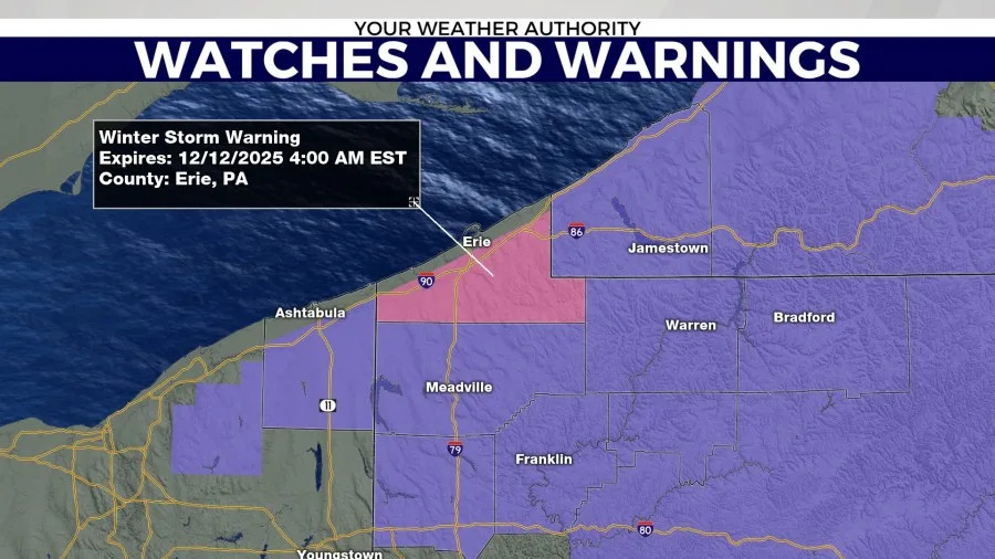
Pink indicates Winter Storm Warning
The NWS offices in Buffalo and State College have also issued lake effect snow warnings. The warnings were issued for Chautauqua County in New York and Warren County in Pennsylvania.
These warnings were put in place early Thursday morning and are in effect until 4 AM on Friday.
Heavy and persistent lake effect snow bands could lead to snowfall accumulations ranging from 4 to 8 inches in parts of Chautauqua County. Parts of Warren County could get 2 to 5 inches, with localized amounts as high as 7 inches in the more persistent snow bands.
Wind gusts between 30 and 40 mph can cause blowing snow and greatly reduced visibility at times. The hazardous conditions could impact the Thursday evening commute.
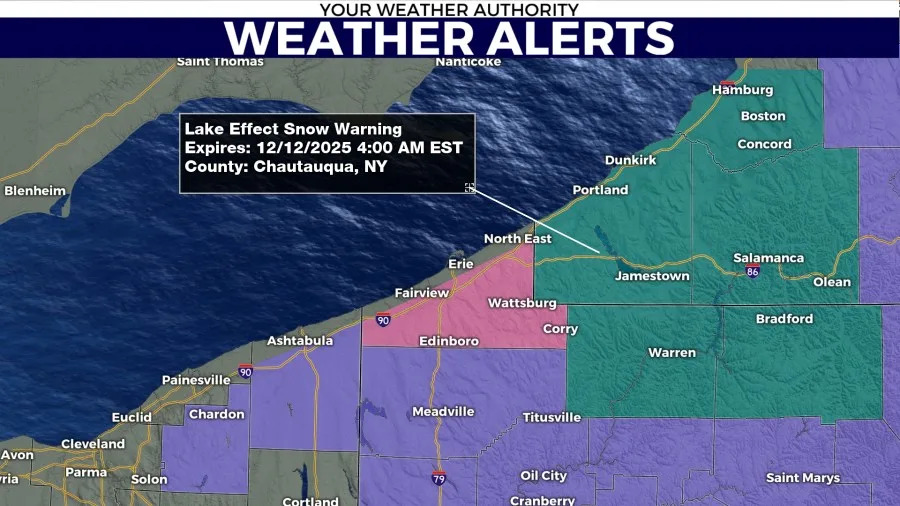
Teal indicates Lake Effect Snow Warning, purple indicates Winter Weather Advisory.
At the same time, winter weather advisories are in place for Crawford, Warren and Venango Counties, along with Ashtabula, OH and Chautauqua, NY, all expiring at different times.
Crawford and Venango County’s advisory will expire at 10 pm Wednesday night with 3-5 inches of snow possible during the day for Crawford County, and up to 2 inches possible for Venango County.
Warren and Chautauqua County’s advisories will be in place until 4 am Friday, with Warren potentially getting 3-6 inches of snow on Wednesday and another 2-6 inches of lake effect snow possible on Thursday night. The NWS said some areas in Warren could get up to a foot of snow over two days.
Chautauqua County snow totals could also reach between 7 and 14 inches over the next two days, with most of it coming in batches, according to the NWS. Wind gusts up to 35 mph could also cause blowing and drifting snow, mainly later Wednesday night through Thursday.
Finally, Ashtabula County’s advisory will be in effect until 9 pm Thursday, with snow totals between 3 and 6 inches and wind gusts up to 40 mph, making for travel conditions similar to previously mentioned counties.
During all of this, officials are encouraging drivers to avoid any unnecessary travel and to be prepared to take more time to get to their destination should they decide to drive.
Copyright 2025 Nexstar Media, Inc. All rights reserved. This material may not be published, broadcast, rewritten, or redistributed.
For the latest news, weather, sports, and streaming video, head to WJET/WFXP/YourErie.com.