
The first part of Saturday is dry, but once the snow starts to fall, you can expect travel impacts and much colder air. A messy weekend awaits. Impact Day Saturday: Snow ReturnsSnow is expected to return late Saturday afternoon with widespread snow in the evening and nighttime hours.Snow showers will last through most of the evening before tapering off early Sunday morning, with 3-5 inches of snow expected areawide. South of Pittsburgh, bands of snow could set up during the event that allows for higher totals. The Laurel Highlands and isolated places south of Pittsburgh could see 6-10 inches of snow by Sunday morning.A Winter Storm Warning has been issued for Washington, Greene, Fayette, Westmoreland, Monongalia, Preston, and Garrett counties. A Winter Weather Advisory has been issued for Allegheny, Armstrong, Beaver, Butler, Clarion, Forest, Indiana, Lawrence, Venango, and parts of Garrett counties. The watch starts at 1 pm Saturday through 1 pm Sunday.Severe Weather Alert Day Sunday: Bitter ColdThe coldest air so far this season is here on Sunday. We will start around 10 degrees. Wind chills will drop likely below zero Sunday morning.Temperatures only warm to about 20 degrees through the day, as wind chills stay in the single digits through the afternoon. It will be dangerous to be outside for extended periods. With a fresh coat of snow and kids off of school, it may be best to have them look at instead of enjoying the snow to keep them safe.Impact Day Monday: Cold ContinuesThe cold continues Monday with low temperatures in the teens and highs in the 20s. Wind chills will likely start near 0° Monday morning. Wind chills will again drop into the single digits for the Steelers game Monday night.We will finally break the arctic blast Tuesday as highs warm to near freezing. Temperatures will reach 50 for the first time this month on Thursday with rain showers.TONIGHT: Increasing clouds, cold. Low 22°SATURDAY – Impact Day: Mostly cloudy with snow showers in the afternoon and evening. High 32°, low: 10°.SUNDAY – Severe Weather Alert Day: Bitter cold. Flurries and light snow possible. High 19°, low: 14°.MONDAY – Impact Day: Flurries north, otherwise continued cold. High: 20°, low: 14°.
PITTSBURGH —
The first part of Saturday is dry, but once the snow starts to fall, you can expect travel impacts and much colder air. A messy weekend awaits.
Impact Day Saturday: Snow Returns
Snow is expected to return late Saturday afternoon with widespread snow in the evening and nighttime hours.
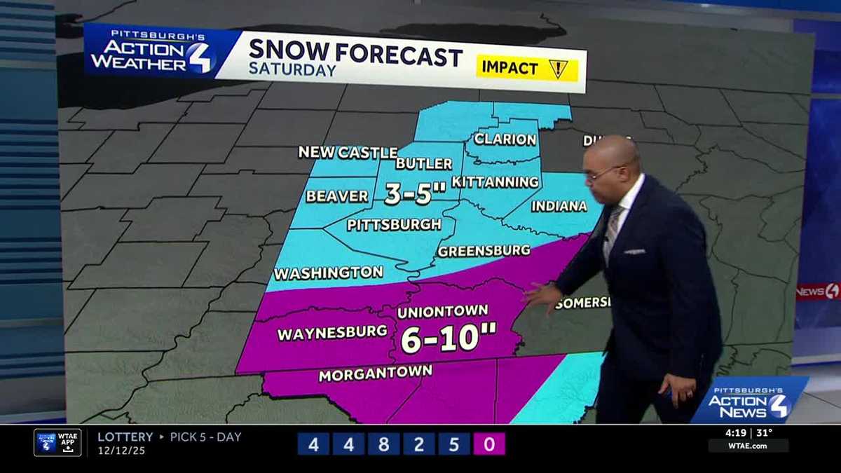
Snow showers will last through most of the evening before tapering off early Sunday morning, with 3-5 inches of snow expected areawide. South of Pittsburgh, bands of snow could set up during the event that allows for higher totals. The Laurel Highlands and isolated places south of Pittsburgh could see 6-10 inches of snow by Sunday morning.

Hearst Owned
Isolated higher amounts of snow are possible south of Pittsburgh, otherwise everyone outside of the Laurel Highlands will see three to five inches of snow.
A Winter Storm Warning has been issued for Washington, Greene, Fayette, Westmoreland, Monongalia, Preston, and Garrett counties. A Winter Weather Advisory has been issued for Allegheny, Armstrong, Beaver, Butler, Clarion, Forest, Indiana, Lawrence, Venango, and parts of Garrett counties. The watch starts at 1 pm Saturday through 1 pm Sunday.

Hearst Owned
Winter Storm Warning and Winter Weather Advisory for Western PA Saturday.
Severe Weather Alert Day Sunday: Bitter Cold
The coldest air so far this season is here on Sunday. We will start around 10 degrees. Wind chills will drop likely below zero Sunday morning.
Temperatures only warm to about 20 degrees through the day, as wind chills stay in the single digits through the afternoon. It will be dangerous to be outside for extended periods. With a fresh coat of snow and kids off of school, it may be best to have them look at instead of enjoying the snow to keep them safe.

Impact Day Monday: Cold Continues
The cold continues Monday with low temperatures in the teens and highs in the 20s. Wind chills will likely start near 0° Monday morning. Wind chills will again drop into the single digits for the Steelers game Monday night.

Hearst Owned
A very cold night for the Steelers home game against the Dolphins.
We will finally break the arctic blast Tuesday as highs warm to near freezing. Temperatures will reach 50 for the first time this month on Thursday with rain showers.

Hearst Owned
A wintry weekend with dangerous cold followed by a return of warmer air.
TONIGHT: Increasing clouds, cold. Low 22°
SATURDAY – Impact Day: Mostly cloudy with snow showers in the afternoon and evening. High 32°, low: 10°.
SUNDAY – Severe Weather Alert Day: Bitter cold. Flurries and light snow possible. High 19°, low: 14°.
MONDAY – Impact Day: Flurries north, otherwise continued cold. High: 20°, low: 14°.