
SHORT TERM FORECAST
TONIGHT: Mostly clear to start, then becoming mostly cloudy overnight; cold and dry. Low: 19
SATURDAY: Mostly cloudy, chilly, and dry. High: 37
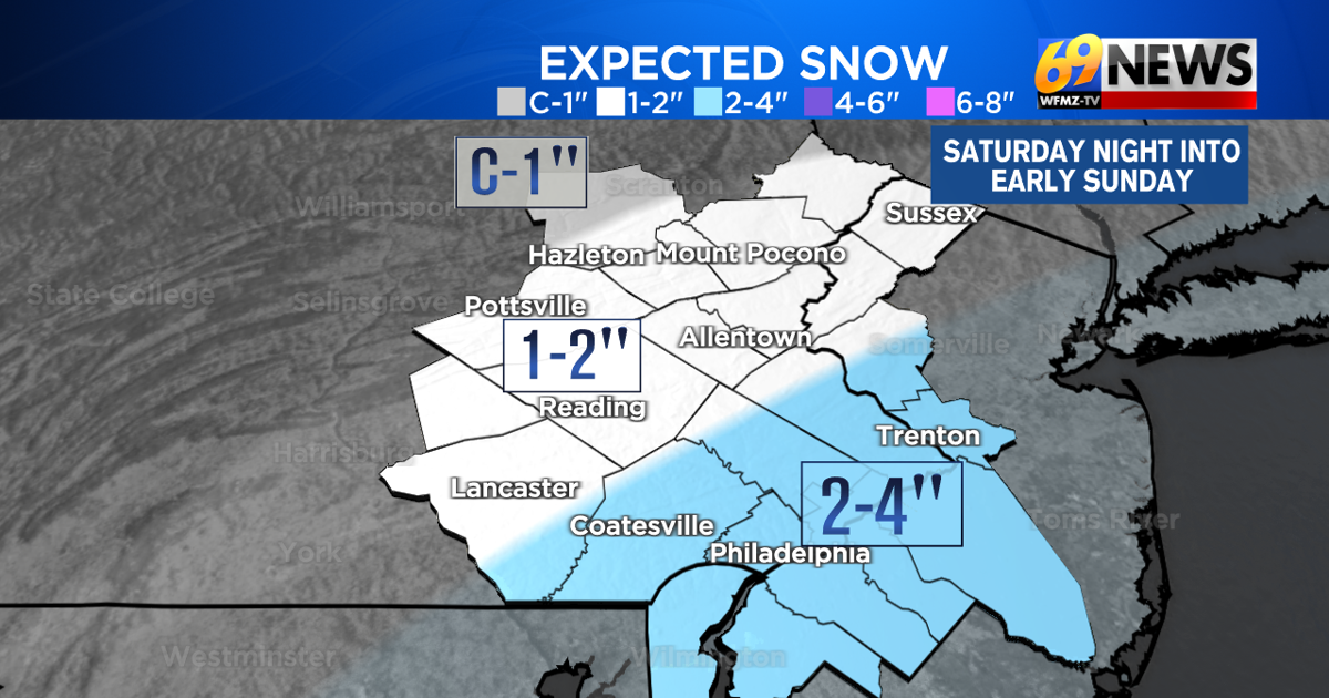
SATURDAY NIGHT: Cloudy with some light snow developing before midnight, and tapering off by sunrise. 1-2″ expected for most, but 2-4″ south and east of the Lehigh Valley towards the I-95 corridor. Low: 22
FORECAST SUMMARY
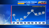
Yes, there’s some snow on the way this weekend. But first, in case you’re counting, Friday was our 16th straight day of colder than average temperatures. Some have been cold, and some have been bitter cold. And there’s one more arctic blast that will settle in later this weekend through early next week, but for the first time all month, there is a reprieve from the cold on the way later next week. Before that happens however, we’ll have a little weekend snow that will usher in the next cold blast. Thankfully, it will be light and fluffy for most, and timed to mostly fall Saturday night while there’s the least amount of traffic on the roads. For most of the area, it’s an inch or two of fluffy and powdery snow by the time you wake up Sunday morning. But south and east of Berks County and the Lehigh Valley, 2 to 4 inches of snow are expected towards the Delaware Valley, the I-95 corridor, and most of central and southern New Jersey. It’s brisk and cold but also drier once that snow ends early Sunday morning, before the first surge of milder air since the day before Thanksgiving slides our way later next week. Come Thursday, highs may not be far from the 50° mark, with some light rain and not snow by Thursday night.

DETAILED FORECAST
TONIGHT
We’ll go into the night with mostly clear skies, but skies should become mostly cloudy overnight. It will be a cold and dry night with light winds and lows in the upper teens and low 20s.
SATURDAY
Expect a mostly cloudy and chilly but a dry day to start the weekend, with highs inching up a few degrees from recent days, reaching the mid to upper 30s by afternoon. Winds will be light, so there won’t be much of a wind chill. Snow will arrive overnight, especially closer to midnight.
SATURDAY NIGHT
Our quick-hitting shot of mostly light and fluffy snow will arrive from late evening to midnight Saturday night, be steadiest in the overnight hours, and then taper off quickly before or around sunrise Sunday morning. It will be plenty cold for all snow, and no mixing or rain concerns like previous systems. But it will be light snow that won’t last long, which will limit accumulations to around 1-2″ for most of the area, including Berks County, the Lehigh Valley, the Poconos, and far North Jersey. Farther south and east, towards the Delaware Valley, the I-95 corridor, and most of central and southern New Jersey, 2-4 inches of snow are expected, with steadier snows falling in this area overnight. Lows will be around 20-25°, so this will be all snow and snow will stick to all surfaces, but amounts should be light and the duration of the event less than 8 hours for most.
SUNDAY AND MONDAY
Any early morning snow around sunrise Sunday morning, mainly from the Delaware Valley to the shore, will quickly end. Skies turn partly sunny, but it will be breezy and cold with steady temps in the mid 20s that could even fall back a bit later in the day. Wind chills will be the in the teens, and there could be a little blowing snow as it will be breezy and the freshly fallen snow will be lightweight and powdery. Come Monday, it will be similarly breezy and cold with highs in the mid 20s, and with mostly cloudy skies.
TUESDAY
This should be the last very cold day for a little while, but it should come with a break from the biting breezes of Sunday and Monday. Look for partly sunny skies and lighter winds, with morning temps in the teens and afternoon highs in the low 30s.
LATER NEXT WEEK
After about three weeks, we’ll finally see milder than average temperatures, if only for a day, on Thursday next week. For Wednesday, expect partly sunny skies and highs inching into the low 40s, finally closer to seasonable levels for mid-December. We’ll do even better than that on Thursday, with mostly cloudy skies but milder highs in the upper 40s. The price we pay will be an increasing southwest breeze, and some rain showers later Thursday and Thursday night. Behind those showers, we’ll return to cooler (but not bitter cold) temps on Friday with highs back in the upper 30s with a brisk breeze.
TRACK THE WEATHER:
LINKS: HOUR BY HOUR | RADAR | TRAFFIC