
Snow continued to fall throughout Saturday night and into early Sunday morning as a storm brings a weekend of messy weather to western Pennsylvania.A winter storm warning was issued by the National Weather Service. As the accumulating snow wraps up overnight, a bitter blast of arctic air will sweep in behind it for Sunday.See the latest forecast from Pittsburgh’s Action Weather in the video above.How long will the snow last?The widespread snow showers that persisted Saturday night are expected to taper off early Sunday morning.South of I-70, there could be localized higher totals in more persistent bands. Winter weather alerts: Read the alert for your countyInteractive radar: Track the snowSevere weather alerts: Sign up for FREE weather alerts to your phone or emailHow much snow will we get?Between 3 and 5 inches of snow is expected area wide.The Laurel Highlands and isolated places south of Pittsburgh could see 5 to 8 inches by Sunday morning.Severe Weather Alert Day Sunday: Bitter ColdThe coldest air so far this season is here on Sunday. We will start the day with temperatures in the low teens. Wind chills will drop near zero in the morning.Temperatures only warm to about 20 degrees through the day on Sunday, as wind chills stay in the low teens through the afternoon.Sunday will feature plenty of clouds and a few isolated flurries, especially in the favored areas near I-80 and the Laurel Highlands, but no additional accumulation is expected.Impact Day Monday: Cold ContinuesThe cold continues on Monday with morning temperatures in the mid teens and afternoon temperatures in the low 20s. Wind chills will be in single digits to start the day.Kickoff for the Steelers-Dolphins game at Acrisure Stadium on Monday night will have a temperature around 18 degrees.We will finally break the arctic blast Tuesday as high temperatures warm into the 30s. Temperatures will reach 50 for the first time this month on Thursday with rain showers.
PITTSBURGH —
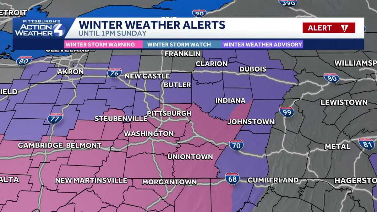
Snow continued to fall throughout Saturday night and into early Sunday morning as a storm brings a weekend of messy weather to western Pennsylvania.
A winter storm warning was issued by the National Weather Service. As the accumulating snow wraps up overnight, a bitter blast of arctic air will sweep in behind it for Sunday.
See the latest forecast from Pittsburgh’s Action Weather in the video above.
How long will the snow last?
The widespread snow showers that persisted Saturday night are expected to taper off early Sunday morning.
South of I-70, there could be localized higher totals in more persistent bands.
Winter weather alerts: Read the alert for your county
Interactive radar: Track the snow
Severe weather alerts: Sign up for FREE weather alerts to your phone or email

How much snow will we get?
Between 3 and 5 inches of snow is expected area wide.
The Laurel Highlands and isolated places south of Pittsburgh could see 5 to 8 inches by Sunday morning.

Severe Weather Alert Day Sunday: Bitter Cold
The coldest air so far this season is here on Sunday. We will start the day with temperatures in the low teens. Wind chills will drop near zero in the morning.
Temperatures only warm to about 20 degrees through the day on Sunday, as wind chills stay in the low teens through the afternoon.
Sunday will feature plenty of clouds and a few isolated flurries, especially in the favored areas near I-80 and the Laurel Highlands, but no additional accumulation is expected.

Impact Day Monday: Cold Continues
The cold continues on Monday with morning temperatures in the mid teens and afternoon temperatures in the low 20s. Wind chills will be in single digits to start the day.
Kickoff for the Steelers-Dolphins game at Acrisure Stadium on Monday night will have a temperature around 18 degrees.
We will finally break the arctic blast Tuesday as high temperatures warm into the 30s. Temperatures will reach 50 for the first time this month on Thursday with rain showers.
