
IMPACT MORNING: Single-digit wind chills, icy roads disrupt commute across south-central Pennsylvania
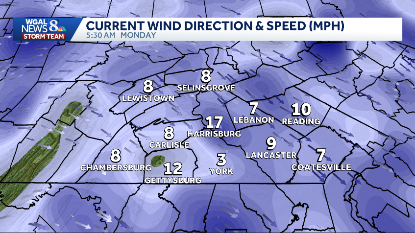
IT IS A COLD MORNING OUT THERE. WE HAVE WIND CHILLS IN THE SINGLE DIGITS TO NEAR ZERO. THE WIND CHILL LAST HOUR IN LANCASTER WAS ONE, SO YOU GET THE IDEA. IT IS COLD. YOU NEED TO DRESS IN LAYERS AND YOU NEED TO GIVE YOURSELF EXTRA TIME FOR YOUR MORNING COMMUTE. THERE’S STILL SOME BLOWING AND DRIFTING SNOW, ESPECIALLY IN RURAL AREAS. THERE COULD BE ICY SPOTS ON THE ROADS, ESPECIALLY IN SHADED AREAS THAT DIDN’T DRY OUT YESTERDAY. SO CURRENT TEMPERATURES FROZEN SOLID 16 IN LEWISTOWN, 14 IN LANCASTER, 13 IN YORK. AND WHEN YOU FACTOR IN THE WIND, WHICH IS STILL BLOWING AT 17MPH IN HARRISBURG, IT FEELS LIKE THREE DEGREES. IT FEELS LIKE TWO IN LANCASTER, FEELING LIKE FIVE IN SELINSGROVE AND CHAMBERSBURG. SO OUR TEMPERATURE TODAY, THAT’S GOING TO GET INTO THE 20S. WE STAY BELOW FREEZING ALL DAY AND LOOK AT THE WIND CHILL. WIND CHILLS WILL BE IN THE TEENS AT BEST LATER THIS AFTERNOON, BUT WINDS FINALLY DIMINISH TONIGHT FOR THE MORNING IMPACTS UNTIL ABOUT 10 A.M. WATCH OUT FOR THOSE ICY PATCHES ON YOUR MORNING DRIVE AND WHERE SNOW HAS BLOWN BACK OVER THE ROAD IN RURAL AREAS, 20 WILL BE THE 9:00 TEMPERATURE. WE GET TO 26 FOR OUR HIGH, A COUPLE OF PASSING SNOW SHOWERS LATE THIS AFTERNOON EARLY EVENING, BUT MAINLY NORTH OF THE TURNPIKE. FOR YOUR BEST BET TO SEE ANY OF THOSE TONIGHT. GRADUAL CLEARING, DIMINISHING WINDS WITH A FRESH BLANKET OF SNOW. IT IS GOING TO BE FRIGID. WE’RE TALKING ABOUT 12 TO 16 DEGREES OVERNIGHT AND TOMORROW. MOSTLY SUNNY, CALM AND COLD. AT LEAST WE GET THE SUN. WE GET THE CALMER WINDS, BUT THESE TEMPERATURES ARE STILL BELOW AVERAGE FOR ONE MORE DAY. STORM TEAM, LIVE RADAR NETWORK. IT IS QUIET NOW. I’M WATCHING A MINOR DISTURBANCE WHICH WILL DIVE ACROSS PENNSYLVANIA TODAY AND BRING IN THAT ISOLATED CHANCE FOR A COUPLE OF SNOW SHOWERS, BUT CURRENTLY IT IS GOOD TO GO FOR THE MORNING COMMUTE. JUST BE MINDFUL OF THOSE ICY PATCHES. HERE’S THE CLOUDS LATER TODAY. THE ISOLATED SNOW SHOWERS NORTH OF THE TURNPIKE, AND THEN THEY CLEAR OUT QUICKLY THIS EVENING. TOMORROW MORNING IT’S A SUNNY START, SUNNY ALL DAY, LOOKING GREAT WITH HIGH PRESSURE IN CONTROL. CLOUDS RETURN ON WEDNESDAY, BUT WE DON’T GET ANY PRECIPITATION. HOWEVER, WEDNESDAY I DO THINK WE COULD WARM INTO THE 40S, SO THAT’S GOING TO BE THE FIRST LITTLE BREAK IN THE COLDER WEATHER THAT WE’VE BEEN STUCK IN SO FAR THIS DECEMBER. WHAT’S UP NEXT? IT’S OUR CHANCE OF RAIN LATE THURSDAY INTO FRIDAY MORNING AND THIS IS GOING TO BE ALL RAIN. SO THIS NEXT SYSTEM IS COMING IN. WE’RE GOING TO WARM UP AHEAD OF IT. AND WE COULD GET AROUND A HALF INCH MAYBE THREE QUARTERS OF AN INCH OF RAIN OUT OF THIS SYSTEM THURSDAY NIGHT INTO FRIDAY MORNING. AFTER THAT, SATURDAY DOES TURN A LITTLE BIT COLDER AT 38, BUT IT’S TEMPORARY. LOOK AT SUNDAY, FIRST DAY OF WINTER ABOVE AVERAGE. WE GO TO 46 DEGREES WITH A CHANCE FOR A COUPLE OF SHOWERS. BRISK ON MONDAY. AT 40. TUESDAY COULD FEATURE A FEW MORE RAIN SHOWERS. AND WEDNESDAY THAT IS CHRISTMAS EVE. REGINA ON THE T
IMPACT MORNING: Single-digit wind chills, icy roads disrupt commute across south-central Pennsylvania

Updated: 6:03 AM EST Dec 15, 2025
Monday is an Impact Morning as some roads are icy with single-digit wind chills across south-central Pennsylvania, creating tricky travel conditions. The Impact Morning is in effect for all of the Susquehanna Valley until 10 a.m. Monday’s ForecastCold, icy morning | Temperatures in the teens; Wind chills in the single digits to near zero degrees.Travel impacts | Watch for icy patches on roads, sidewalks and parking lots; Blowing and drifting snow is possible, especially in rural areas.During the day | Early sunshine before clouds increase late morning into the afternoon. Tonight | Skies will clear, and winds will diminish; Lows fall to the low to mid-teens.Snow chancesA weak disturbance will bring a few snow showers across the region Monday afternoon and evening. The highest chance of light snow is north of the Pennsylvania Turnpike. Little to no accumulation is expected. School delaysMore than 200 schools have announced delays for Monday morning. To see the full list of closings and delays, click here. Stay weather aware with WGAL’s online toolsRADAR: Track severe weather with WGAL’s interactive radar.LOCATION-BASED ALERTS: Instructions for activating our customized weather alerts are here.CLOSINGS: When severe weather strikes, see if businesses, churches or organizations have closed or delayed.ROAD CLOSURES: Our interactive traffic map is always updated with crashes, construction and road closures. It even has a weather radar overlay.EMAIL ALERTS: We’ll send you daily updates, or just alerts when severe weather is headed your way.HOUR-BY-HOUR: See what you can expect every day with the hourly forecast.WEEKEND WEATHER: Know what to expect before you make your plans.10-DAY FORECAST: Check WGAL’s extended forecast here.
Monday is an Impact Morning as some roads are icy with single-digit wind chills across south-central Pennsylvania, creating tricky travel conditions.
The Impact Morning is in effect for all of the Susquehanna Valley until 10 a.m.
Monday’s Forecast
Cold, icy morning | Temperatures in the teens; Wind chills in the single digits to near zero degrees.
Travel impacts | Watch for icy patches on roads, sidewalks and parking lots; Blowing and drifting snow is possible, especially in rural areas.
During the day | Early sunshine before clouds increase late morning into the afternoon.
Tonight | Skies will clear, and winds will diminish; Lows fall to the low to mid-teens.
Snow chances
A weak disturbance will bring a few snow showers across the region Monday afternoon and evening.
The highest chance of light snow is north of the Pennsylvania Turnpike.
Little to no accumulation is expected.
School delays
More than 200 schools have announced delays for Monday morning.
To see the full list of closings and delays, click here.