
IMPACT MORNING:It’s a frigid start to the day, with temperatures in the teens and wind chills in the single digits to near 0. Watch for icy patches on your morning commute, and blowing and drifting snow, especially in rural areas. We’ll see morning sunshine today, then increasing clouds. A weak disturbance will bring a few snow showers across the area this afternoon and evening. The highest chance of a light snow shower is north of the PA Turnpike. Expect little to no accumulation. Tonight, the sky will clear, winds will diminish, and temperatures will plummet to the low-teens. After another frigid start Tuesday, building high pressure will deliver sunshine and calm winds. Highs will reach the mid-30s, which is still below our average high of 43 degrees..By Wednesday, clouds return, and temperatures warm to the mid-40s. Ahead of a cold front, Thursday will be the mildest day of the week. Highs will reach the upper 40s, with rain developing late. Rain will fall overnight Thursday, ending Friday morning. Rain totals will range between 0.50″ and 1″. It will turn windy behind the cold front Friday. Highs will be a few degrees above average, near 44. Saturday will feature chilly highs in the upper 30s with a brisk breeze, then a chance of rain showers and milder temperatures in the mid-40s return Sunday. Next week, temperatures will remain close to average, which is 40 degrees for the end of December.
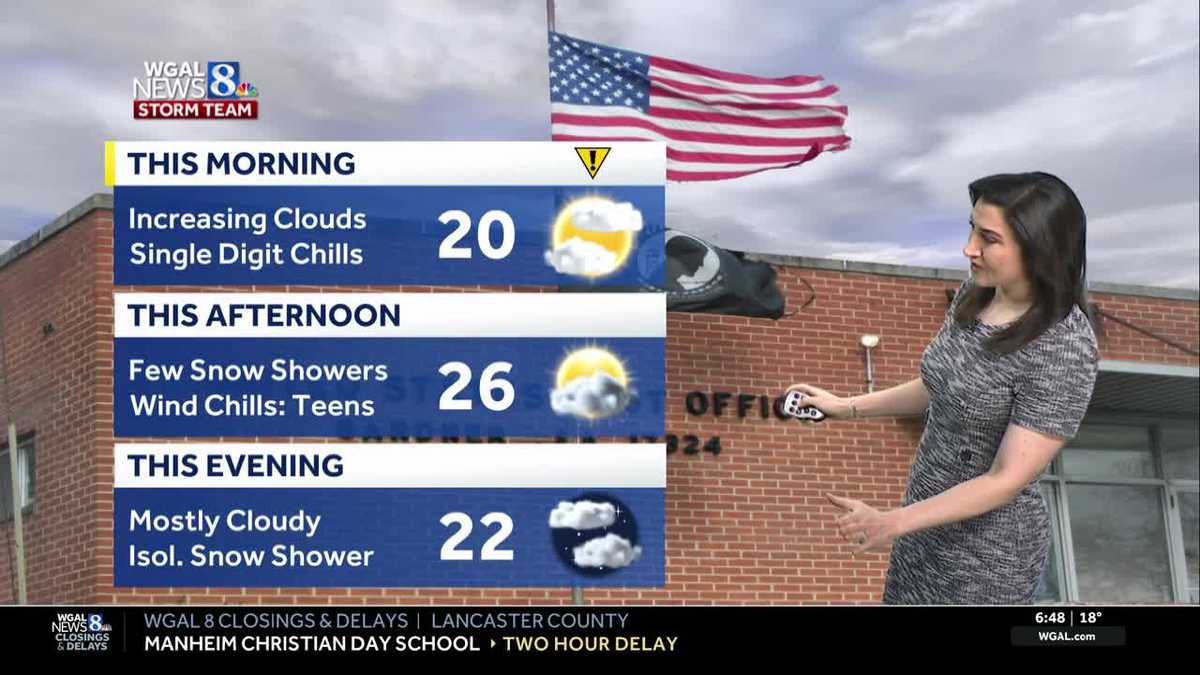
IMPACT MORNING:
It’s a frigid start to the day, with temperatures in the teens and wind chills in the single digits to near 0. Watch for icy patches on your morning commute, and blowing and drifting snow, especially in rural areas.
We’ll see morning sunshine today, then increasing clouds. A weak disturbance will bring a few snow showers across the area this afternoon and evening. The highest chance of a light snow shower is north of the PA Turnpike. Expect little to no accumulation.
Tonight, the sky will clear, winds will diminish, and temperatures will plummet to the low-teens.
After another frigid start Tuesday, building high pressure will deliver sunshine and calm winds. Highs will reach the mid-30s, which is still below our average high of 43 degrees..
By Wednesday, clouds return, and temperatures warm to the mid-40s.
Ahead of a cold front, Thursday will be the mildest day of the week. Highs will reach the upper 40s, with rain developing late. Rain will fall overnight Thursday, ending Friday morning. Rain totals will range between 0.50″ and 1″.
It will turn windy behind the cold front Friday. Highs will be a few degrees above average, near 44.
Saturday will feature chilly highs in the upper 30s with a brisk breeze, then a chance of rain showers and milder temperatures in the mid-40s return Sunday.
Next week, temperatures will remain close to average, which is 40 degrees for the end of December.