
The bitter cold continues today with feels like temperatures in the single digits to lower teens and an Impact Day. A thaw is coming with highs surging through the 40s and lower 50s by mid-week. We are also tracking rain chances late Thursday.Impact Day: Arctic air and biting wind chillsA number of neighborhoods are waking up to sub-zero wind chills. A Cold Weather Advisory is in effect through 9 a.m. for the Laurel Highlands, where wind chills could be as low as 15 to 20 degrees below zero. Feels like temperatures will only reach the lower teens this afternoon. A few flurries will also cruise through western PA, especially closer to I-80.Clouds will start breaking late this afternoon. It will be partly cloudy for Monday Night Football with kickoff temperatures at Acrisure Stadium around 18°, but feeling like the upper single digits.Thawing out mid-weekA warming trend is on the way! High temperatures will reach freezing Tuesday. The thaw will push readings into the 40s on Wednesday and near 50° on Thursday. We can expect some rays of sunshine too tomorrow and Wednesday.Rain chances late ThursdayOur next system brings rain chances late Thursday. The timing could impact the evening commute. We will continue to fine tune that part of the forecast. A few sprinkles or flurries will linger into Friday morning. Roads may be slick in spots too. A brief chill to end the week with highs only in the lower 30s. Temperatures will trend more seasonal for the weekend with highs in the mid 40s. This is the beginning of a pattern change. It looks like it won’t be a white Christmas for western Pennsylvania this year.TODAY – Impact Day: Bitterly cold with morning wind chills near zero. Feeling like the single digits through the afternoon. Some late clearing. High: 22°.TONIGHT: Very cold with more clearing. Low: 14°.TUESDAY: Partly cloudy and chilly. High: 32°, low: 29°.WEDNESDAY: Increasing clouds and turning breezy. High: 43°, low: 33°.THURSDAY: Mild with late-day rain. High: 52°, low: 28°.
PITTSBURGH —
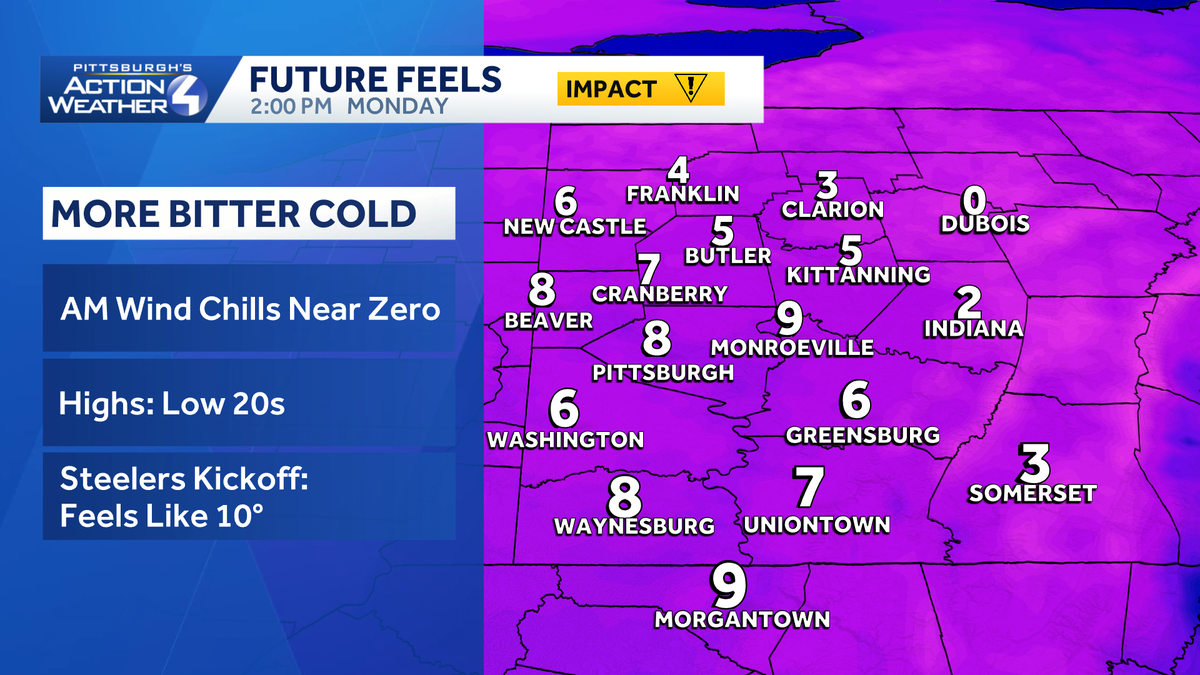
The bitter cold continues today with feels like temperatures in the single digits to lower teens and an Impact Day. A thaw is coming with highs surging through the 40s and lower 50s by mid-week. We are also tracking rain chances late Thursday.
Impact Day: Arctic air and biting wind chills
A number of neighborhoods are waking up to sub-zero wind chills. A Cold Weather Advisory is in effect through 9 a.m. for the Laurel Highlands, where wind chills could be as low as 15 to 20 degrees below zero. Feels like temperatures will only reach the lower teens this afternoon. A few flurries will also cruise through western PA, especially closer to I-80.

Hearst OwnedHearst
An Impact Day for bitterly cold temperatures and potentially dangerous wind chills in the single digits.
Clouds will start breaking late this afternoon. It will be partly cloudy for Monday Night Football with kickoff temperatures at Acrisure Stadium around 18°, but feeling like the upper single digits.

Hearst OwnedHearst
Layer up in black and gold for the Steelers and Dolphins Monday night match up.
Thawing out mid-week
A warming trend is on the way! High temperatures will reach freezing Tuesday. The thaw will push readings into the 40s on Wednesday and near 50° on Thursday. We can expect some rays of sunshine too tomorrow and Wednesday.

Hearst OwnedHearst
Temperatures thaw out by mid-week with highs in the 40s Wednesday.
Rain chances late Thursday
Our next system brings rain chances late Thursday. The timing could impact the evening commute. We will continue to fine tune that part of the forecast. A few sprinkles or flurries will linger into Friday morning. Roads may be slick in spots too. A brief chill to end the week with highs only in the lower 30s.
Temperatures will trend more seasonal for the weekend with highs in the mid 40s. This is the beginning of a pattern change. It looks like it won’t be a white Christmas for western Pennsylvania this year.

Hearst OwnedHearst
A brief trip back near freezing on Friday before temperatures trend milder over the weekend.
TODAY – Impact Day: Bitterly cold with morning wind chills near zero. Feeling like the single digits through the afternoon. Some late clearing. High: 22°.
TONIGHT: Very cold with more clearing. Low: 14°.
TUESDAY: Partly cloudy and chilly. High: 32°, low: 29°.
WEDNESDAY: Increasing clouds and turning breezy. High: 43°, low: 33°.
THURSDAY: Mild with late-day rain. High: 52°, low: 28°.