
The bitter cold continues Monday with feels-like temperatures in the single digits to lower teens. Monday is an Impact Day.A thaw is coming with high temperatures surging through the 40s and lower 50s by mid-week. We are also tracking rain chances late Thursday.Watch the Pittsburgh’s Action Weather forecast in the video aboveSevere weather alerts: Get FREE weather alerts to your phone or email Impact Day: Arctic air and biting wild chillsA number of neighborhoods woke up to sub-zero wind chills in the morning. Feels like temperatures will only reach the lower teens in the afternoon. A few snow flurries will also cruise through western PA, especially closer to Interstate 80.Interactive radar: Track the snowClouds will start breaking late this afternoon. It will be partly cloudy for Monday Night Football with kickoff temperatures at Acrisure Stadium around 16 degrees but feeling like the single digits.Thawing out mid-week A warming trend is on the way.High temperatures will reach freezing Tuesday. The thaw will push readings into the 40s on Wednesday and near 50 degrees on Thursday.We can also expect some rays of sunshine Tuesday and Wednesday.Temperatures will trend more seasonal for the weekend with highs in the 40s.This is the beginning of a pattern change. It looks like we won’t see a white Christmas in western Pennsylvania this year.TODAY – Impact Day: Feeling like the single digits through the afternoon. Some late clearing. High: 21.TONIGHT: Very cold with more clearing. Low: 12.TUESDAY: Partly cloudy and chilly. High: 32, low: 29.WEDNESDAY: Increasing clouds and turning breezy. High: 40, low: 28.THURSDAY – Impact Day: Mild with late-day rain. High: 50, low: 25.
PITTSBURGH —
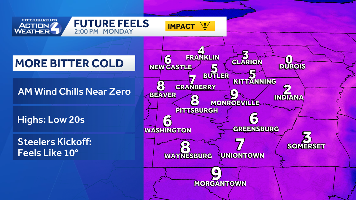
The bitter cold continues Monday with feels-like temperatures in the single digits to lower teens. Monday is an Impact Day.
A thaw is coming with high temperatures surging through the 40s and lower 50s by mid-week. We are also tracking rain chances late Thursday.
Impact Day: Arctic air and biting wild chills
A number of neighborhoods woke up to sub-zero wind chills in the morning. Feels like temperatures will only reach the lower teens in the afternoon. A few snow flurries will also cruise through western PA, especially closer to Interstate 80.
Clouds will start breaking late this afternoon. It will be partly cloudy for Monday Night Football with kickoff temperatures at Acrisure Stadium around 16 degrees but feeling like the single digits.
Thawing out mid-week
A warming trend is on the way.
High temperatures will reach freezing Tuesday. The thaw will push readings into the 40s on Wednesday and near 50 degrees on Thursday.
We can also expect some rays of sunshine Tuesday and Wednesday.
Temperatures will trend more seasonal for the weekend with highs in the 40s.
This is the beginning of a pattern change. It looks like we won’t see a white Christmas in western Pennsylvania this year.
TODAY – Impact Day: Feeling like the single digits through the afternoon. Some late clearing. High: 21.
TONIGHT: Very cold with more clearing. Low: 12.
TUESDAY: Partly cloudy and chilly. High: 32, low: 29.
WEDNESDAY: Increasing clouds and turning breezy. High: 40, low: 28.
THURSDAY – Impact Day: Mild with late-day rain. High: 50, low: 25.