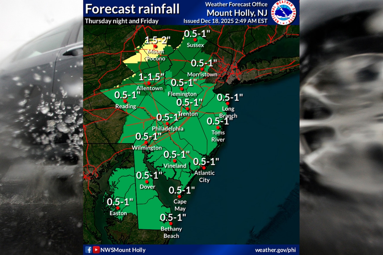
A powerful storm system will bring heavy rain and strong winds to the Lehigh Valley and Poconos on Thursday night and Friday, with wind gusts potentially reaching 45 mph and regional rainfall amounts between half an inch and two inches.
The National Weather Service has issued a Wind Advisory for the entire region starting at 1 a.m. Friday. Rain will begin overspreading the area overnight.
In the Lehigh Valley and Poconos, widespread rain is expected to move in by 9 or 10 p.m. Thursday and gradually move east. Thunderstorms are possible after 4 a.m. Friday. Areas north of Interstate 78 may see the highest rainfall totals of up to 2 inches.
“Even with a decent snowpack in place, flooding impacts are anticipated to be limited and mainly just in urban and poor drainage areas,” the weather service notes in its forecast discussion.
Rain will continue through the morning commute Friday but should move out quickly during the midday hours. Winds will shift from the east to south and finally west as the storm moves through the region.
Speeds are forecast at 5 to 15 mph overnight, gusting to 30 mph, and 20 to 25 mph on Friday, gusting as high as 45 mph in the Lehigh Valley.
“Gusty winds will blow around unsecured objects,” the advisory states. “Tree limbs could be blown down and a few power outages may result.”
Temperatures will initially rise into the 50s overnight before rapidly dropping on Friday, with temperatures falling into the upper 30s and low 40s by afternoon. A strong cold front will drive these temperature changes, accompanied by potentially damaging wind gusts.
While severe weather risks are low, residents should prepare for challenging morning commute conditions due to heavy rain and gusty winds.
The weekend will bring cooler, drier conditions with highs in the upper 30s and low 40s. Saturday will feature diminishing winds and clear skies, providing a respite from the stormy Friday. A cold front will cross the area on Sunday, likely remaining dry, with temperatures returning closer to seasonal norms.
Looking ahead, there’s a 30% to 40% chance of potential snow or rain on Tuesday, followed by more stable weather on Wednesday, which is Christmas Eve.
Residents should stay informed about changing weather conditions and be prepared for rapid shifts in temperature and wind patterns.
Current weather radar