
Clear, cold, & calmer overnight; tracking a wintry mix overnight Monday in south-central Pennsylvania
As high pressure builds east, winds have relaxed and skies remain clear. We’re tracking a system that may bring a wintry mix overnight Monday into Tuesday. Milder temperatures return closer to Christmas.
OFF. OR I SHOULD SAY, THE HOLIDAY WEEK OFF. ON A BRIGHT NOTE, IT’LL BE A QUIET START TO THE WEEK WITH PLENTY OF SUNSHINE EARLY, BUT THEN ONCE WE GET INTO THE AFTERNOON AND THE EVENING, THAT’S WHEN WE’LL START TO SEE SOME INCREASING CLOUDS JUST AHEAD OF OUR NEXT QUICK MOVING SYSTEM THAT’S GOING TO MOVE THROUGH OVERNIGHT MONDAY INTO TUESDAY MORNING. YOU CAN SEE HERE WE COULD SEE SOME LIGHT SNOW AND MIX OVERNIGHT MONDAY INTO TUESDAY MORNING. LET’S CHAT ABOUT THAT HERE IN JUST A FEW MINUTES. BUT THEN ONCE WE GET INTO THE REST OF THE HOLIDAY WEEK, OR ESPECIALLY CLOSER TOWARDS THE END OF THE WORKWEEK TOWARDS THURSDAY AND FRIDAY, THAT’S WHEN WE’LL SEE A FEW SHOWER CHANCES. CHRISTMAS DAY MORE, SOME MORE SHOWER CHANCES FOR YOUR FRIDAY. ALSO TURNING MILDER, WE’RE GOING TO SEE TEMPERATURES REACH THE 50 DEGREE MARK FOR YOUR FRIDAY OVERNIGHT TONIGHT, MAINLY CLEAR CONDITIONS WITH DECREASING WINDS OUT OF THE NORTHWEST REMAINING RIGHT INTO THE 20S MARK FOR OVERNIGHT LOWS, THEN WILL BE MOSTLY SUNNY. A LITTLE BIT OF A CHILLY START FOR TOMORROW. YOU CAN SEE 26 TO 30 DEGREES FOR THE MORNING, AND BY THE AFTERNOON WILL BE BACK UP TO RIGHT AROUND 38 DEGREES. BUT WE’LL START TO SEE THOSE CLOUDS MOVE IN, REMAINING COOL SOUTHERLY BREEZE OUT OF A SOUTHERLY BREEZE BETWEEN 5 AND 10MPH. SO SHOULD BE A DECENT DAY SETTING UP FOR US. BUT HERE’S SOME OF THE STATISTICS FOR THE DAY TODAY. 44. THAT WAS OUR HIGH FROM INTERNATIONAL FROM HARRISBURG INTERNATIONAL AIRPORT 42. THAT’S WHAT WE EXPECT FOR THIS TIME OF THE YEAR. SO IT’S NOT WE’RE RIGHT AROUND PAR FOR WHAT WE EXPECT. AND ALONG WITH THE LOW TEMPERATURES EARLIER THIS MORNING, LAST NIGHT’S LOW IS RIGHT AROUND 24 DEGREES. THAT’S RIGHT AROUND PAR IN TERMS OF SEASONABLE AVERAGES. SO IF YOU’RE HEADED TO THE HERSHEY PARK CHRISTMAS CANDY LANE FOR YOUR MONDAY, THAT’S GOING TO BE FROM 5 TO 9. WE’RE GOING TO BE REMAINING CLOUDY FOR THE EVENING. THAT’S WHEN THAT’S BE JUST AHEAD OF OUR NEXT SYSTEM. BUT WE’LL BE RIGHT INTO THE MID 30S, DROPPING TO THE LOWER 30S AS WE GET CLOSER TOWARDS TOWARDS THE EVENING, CLOSER TO FIVE TO TO 9:00 AT NIGHT. BUT WE’RE RIGHT AROUND THE 28 DEGREE MARK FOR LANCASTER, 31 IN HARRISBURG, 30 IN YORK AND GETTYSBURG. AT THIS TIME, SUSTAINED WINDS ARE STILL OUT OF THE NORTHWEST, I’D SAY BETWEEN 5 AND 15MPH. YOU CAN SEE A 15 MILE PER HOUR BREEZE IN HARRISBURG, A CALMER BREEZE TOWARDS CHAMBERSBURG AND GETTYSBURG, ABOUT A TEN MILE PER HOUR BREEZE IN LEWISTOWN. THAT’S WHAT ALLOWS THOSE TEMPERATURES TO FEEL LIKE THEY’RE IN THE LOWER 20S OR IN SOME INSTANCES, LIKE SELINSGROVE IN LEWISTOWN, DOWN INTO THE UPPER TEENS, IS WHAT IT FEELS LIKE. SO THANKS TO HIGH PRESSURE BUILT IN OVER THE AREA, THAT’S WHAT’S HELPING TO PROMOTE MAINLY CLEAR CONDITIONS. OVERNIGHT TONIGHT, GETTING INTO TOMORROW MORNING. BUT THEN ONCE WE GET INTO THE AFTERNOON, THIS IS WHAT WE’RE TRACKING. YOU SEE THIS LITTLE BIT OF A BAND OF SOME OF SOME SNOW POSSIBLY. NOW I WANT TO POINT THIS OUT. SO WHAT WE’RE EXPERIENCING RIGHT NOW IS IN TERMS OF THE MODEL DATA, THIS THIS IS SPECIFICALLY IS CALLED THE GRAPH MODEL. THIS IS SHOWING US A PRETTY DECENT AMOUNT OF SNOW, ALTHOUGH THERE IS A LITTLE BIT OF SOME OF A SPLIT AND SOME GUIDANCE IN TERMS OF WHAT OTHER MODEL OUTPUT IS SAYING. FOR EXAMPLE, WE HAVE THE GFS MODEL, WHICH IS WHAT YOU SEE HERE. THE AMERICAN MODEL IS SUGGESTING WE SEE MORE SO OF A MIX OF SOME SLEET, POSSIBLY SOME RAIN, AND POSSIBLY SOME SNOW. BUT THEN THE EUROPEAN MODEL IS SUGGESTING ONLY LITTLE BITS AND PIECES OF OF OF SOME SLEET AND SNOW AND RAIN. SO AT THIS TIME WE’RE PRETTY CONFIDENT THAT WE’RE GOING TO BE SEEING A WINTRY MIX AS WE GET INTO OVERNIGHT MONDAY INTO TUESDAY. ALTHOUGH THE FORECASTING CHALLENGES, THERE’S NOT A WHOLE LOT OF MOISTURE WITH THIS SYSTEM. AND SO THAT’S WHAT MAKES IT TOUGH TO BE ABLE TO DISTINGUISH WHAT’S GOING TO BE WHAT IN TERMS OF SLEET AND SNOW AND RAIN. BUT THEN ALSO WE HAVE BORDERLINE TEMPERATURES AROUND FREEZING. SOME COMMUNITIES WILL BE BELOW FREEZING. SOME COMMUNITIES WILL BE ABOVE FREEZING. SO IT’S REALLY GOING TO GOING TO DEPEND ON IN TERMS OF THOSE TEMPERATURES, ON WHAT YOU’LL BE SEEING ACROSS THE AREA. BUT WE’RE PRETTY CONFIDENT AS WE GET TO MONDAY NIGHT INTO TUESDAY MORNING THAT WE’LL SEE A WINTRY MIX, THEN TO PLAIN RAIN FOR OVERNIGHT MONDAY. SO NOT A WHOLE LOT OF MOISTURE ONCE AGAIN, BORDERLINE TEMPERATURES JUST BELOW FREEZING, AND IT WILL BE A SLOW MORNING COMMUTE FOR YOUR TUESDAY. POSSIBLY. MIGHT SEE SOME SLICK TRAVEL ON THE ROADS. SO THAT’S WHY WE HAVE IT AS AN IMPACT NIGHT. MONDAY NIGHT. GETTING INTO EARLY TUESDAY MORNING. YOU CAN SEE THAT’S WHY WE HAVE IT HIGHLIGHTED AS AN IMPACT DAY FOR. WE’RE GETTING INTO TUESDAY, BUT THEN LOOKING AHEAD INTO THE REST OF THE WORKWEEK OR THE HOLIDAY WEEK I SHOULD SAY LOOKING AT SOME SCATTERED SHOWER CHANCES FOR YOUR THURSDAY, FRIDAY, ANOTHER CHANCE OF SOME SHOWERS,
Clear, cold, & calmer overnight; tracking a wintry mix overnight Monday in south-central Pennsylvania
As high pressure builds east, winds have relaxed and skies remain clear. We’re tracking a system that may bring a wintry mix overnight Monday into Tuesday. Milder temperatures return closer to Christmas.

Updated: 10:50 PM EST Dec 21, 2025
Thanks to high pressure building in from the west tonight, winds are beginning to relax and skies are continuing to clear. This combination will allow for temperatures to drop to the lower 20s for tonight.To start the holiday week, Monday morning will feature sunny and chilly conditions. High pressure continues to build eastward and will shift off the coast, providing southerly winds and contribute to climbing temperatures in the upper 30s. Winds will be lighter. Heading into the afternoon, our next system will help increase our cloud cover and allow for mostly cloudy conditions to develop by the middle of the afternoon and evening.IMPACT PERIODAn approaching warm front Monday evening will bring more clouds. Overnight, with temperatures at or below freezing, light snow will develop. It will mix with freezing rain and rain as temperatures climb to freezing or above. The wintry mix continues into the morning drive making it an impact period. Challenges to the forecast are the lack of abundant moisture and the temperatures. The News 8 Storm Team will monitor changes and provide updates to the forecast.The rest of Tuesday remains cloudy and dry with temperatures slowly rising late in the day into the low 40s.High pressure provides a mostly sunny day Wednesday. It will be a great day to travel or do some last-minute holiday shopping. Highs are mild in the low to mid 40s.Another system will bring a few showers on Christmas Day with a better chance on Friday. Temperatures are milder in the upper 40s Thursday and low 50s Friday.Have a great rest of your night!~ Ryan
Thanks to high pressure building in from the west tonight, winds are beginning to relax and skies are continuing to clear. This combination will allow for temperatures to drop to the lower 20s for tonight.
To start the holiday week, Monday morning will feature sunny and chilly conditions. High pressure continues to build eastward and will shift off the coast, providing southerly winds and contribute to climbing temperatures in the upper 30s. Winds will be lighter. Heading into the afternoon, our next system will help increase our cloud cover and allow for mostly cloudy conditions to develop by the middle of the afternoon and evening.
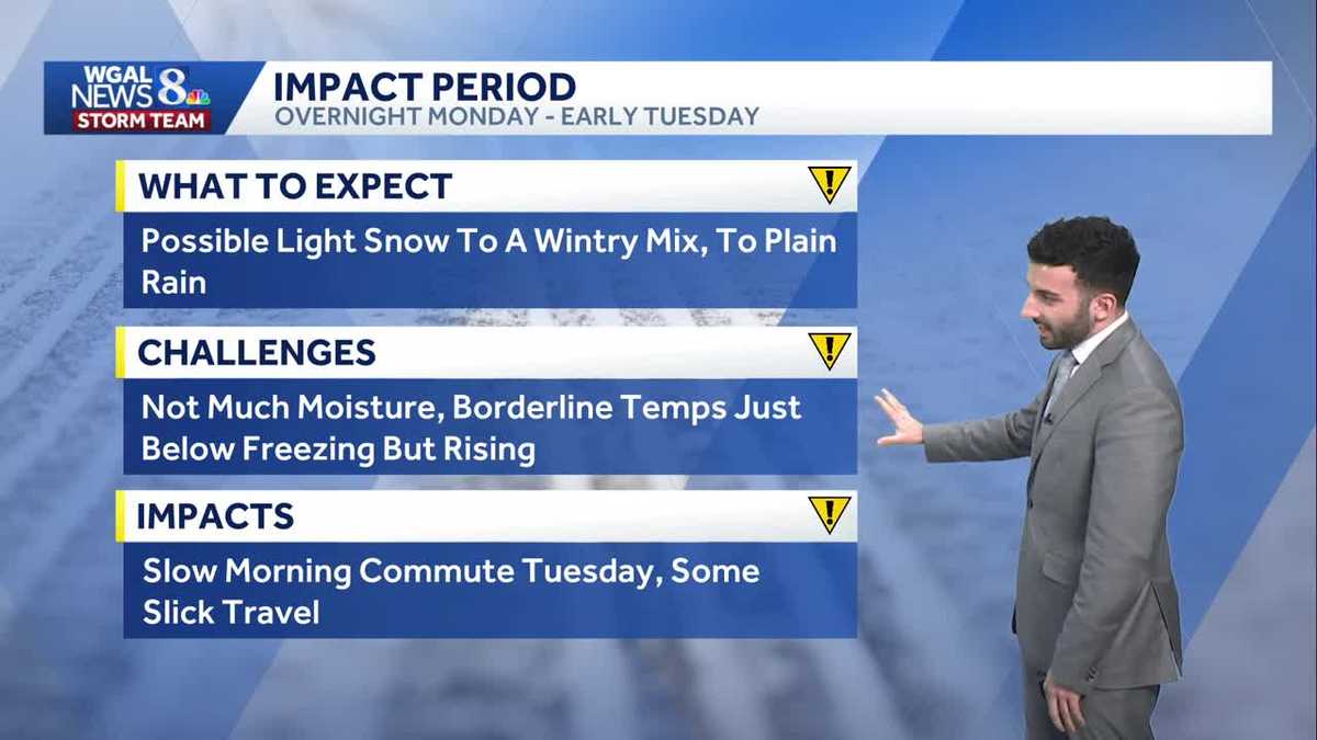
IMPACT PERIOD
An approaching warm front Monday evening will bring more clouds. Overnight, with temperatures at or below freezing, light snow will develop. It will mix with freezing rain and rain as temperatures climb to freezing or above. The wintry mix continues into the morning drive making it an impact period. Challenges to the forecast are the lack of abundant moisture and the temperatures. The News 8 Storm Team will monitor changes and provide updates to the forecast.
The rest of Tuesday remains cloudy and dry with temperatures slowly rising late in the day into the low 40s.
High pressure provides a mostly sunny day Wednesday. It will be a great day to travel or do some last-minute holiday shopping. Highs are mild in the low to mid 40s.
Another system will bring a few showers on Christmas Day with a better chance on Friday. Temperatures are milder in the upper 40s Thursday and low 50s Friday.
Have a great rest of your night!
~ Ryan