
IMPACT: Strong winds & falling temperatures today across south-central Pennsylvania
A Wind Advisory is in effect until 1 AM Saturday for the entire Susquehanna Valley. Strong winds are expected throughout the day followed by a dry, seasonable weekend. More chances for rain heading into Christmas week
EIGHT. STORM TEAM LIVE RADAR NETWORK. YOU CAN SEE SOME OF THESE SHOWERS ALREADY BEGINNING TO MOVE OUT. YOU CAN SEE ALREADY MOVING OUT EAST AS JUST JUST ALONG A COLD FRONT. BUT NOW WE’RE SEEING ANOTHER SECOND BAND OF SOME SHOWERS BEGINNING TO MOVE IN INTO ON ON TO FRANKLIN COUNTY, ALSO INTO OUR WESTERN COUNTIES OF MIFFLIN, JUNIATA AND PERRY COUNTIES AT THIS TIME COULD SEE A FEW MORE RAIN SHOWERS. AND ALSO YOU CAN SEE THERE’S A LITTLE BIT A LITTLE BIT OF SNOW MIXED IN. I DO EXPECT TO SEE A FEW, MAYBE, MAYBE A FEW SNOW SHOWERS FOR OUR OR FOR THE HIGHER ELEVATIONS OR COMMUNITIES IN THE HIGHER ELEVATIONS. BUT THE BIG STORY FOR TODAY, THOUGH, IT’S AN IMPACT DAY. IT’S GOING TO BE COLDER TODAY. BUT THE STORY IS GOING TO BE THESE WINDS ARE ALREADY STARTING TO SEE THE WINDS STARTING TO COME OUT OF THE WEST NORTHWEST BETWEEN 15 TO 25MPH, GUSTING TO 40 TO 45 MILES. MILES PER HOUR TODAY. IT WILL BE A CALMER WEEKEND. WE’LL START SEASONABLE INTO THE LOWER 40S AND THEN MID 40S BY THE TIME WE GET TO SUNDAY. SO MILDER FOR THIS TIME OF THE YEAR. THEN WE’RE LOOKING AT SOME MORE CHANCES FOR RAIN AS WE GET INTO CHRISTMAS WEEK, WHICH IS ALREADY NEXT WEEK, EVERYBODY. NEXT THURSDAY. SO FOR TODAY, WE’RE LOOKING AT AN IMPACT DAY. WE DO HAVE A WIND ADVISORY IN EFFECT THAT WILL BE LASTING UNTIL 1 A.M. SATURDAY MORNING. WE’LL SEE A MIX OF SOME SUN AND CLOUDS AND STILL WINDY. STILL GOT THESE WINDS OUT OF THE WEST. 15 TO 25MPH COULD GUST TO ABOUT 4045. MAYBE ISOLATED AREAS, POTENTIALLY 50MPH. AND WE’RE GOING TO SEE THESE TEMPERATURES FALL. WE’RE INTO THE 40S AND 50S FOR SOME AREAS, BUT IT’S GOING TO BE DOWN INTO THE 30S BY THE TIME YOU LEAVE WORK TODAY. LATER THIS EVENING, PARTLY TO MOSTLY CLEAR AS WE GET INTO TONIGHT, WE DO HAVE A LITTLE BIT OF HIGH PRESSURE THAT’S GOING TO BUILD IN THAT WILL HELP TO EASE THE WINDS SLIGHTLY. STILL A LITTLE BIT BREEZY, I’LL SAY. STILL LEFT THAT BREEZY FOR OVERNIGHT TONIGHT, BUT PAIR THAT WITH THE TEMPERATURES IN THE 20S. IT’S GOING TO BE MAKING IT FEEL LIKE IT’S GOING TO BE INTO THE TEENS FOR OVERNIGHT TONIGHT. THEN FOR THEN WILL BE PARTLY SUNNY WITH SOME LIGHTER WINDS OUT OF THE WEST AND THEN TURNING SOUTHEAST BETWEEN 5 AND 15MPH. SO A LITTLE BIT OF A SEASONAL CHILL IN THE AIR AS WE GET INTO TOMORROW. 38 TO 42 DEGREES. BUT HERE ARE THE CURRENT SUSTAINED WINDS, LET’S SAY BETWEEN 15 AND 25MPH. ALREADY SEE SOME HIGHER, HIGHER WIND SPEEDS OFF TOWARDS OUR WEST, JUST WEST OF THE SUSQUEHANNA VALLEY. THAT’S GOING TO MOVE IN AS WE GET INTO THE AFTERNOON. CHECK THIS OUT. THE HIGHEST SUSTAINED WINDS CLOSER TO THREE 4:00 THIS AFTERNOON, AND THEN THEY WON’T BE DYING DOWN UNTIL LATER OVERNIGHT TONIGHT INTO EARLY TOMORROW MORNING. YOU CAN SEE THE TIME STAMP THERE IS RIGHT AROUND 6:00 SATURDAY MORNING. THAT’S WHEN WE’RE EXPECTING, REALLY TO SEE THESE WINDS DIE DOWN. BUT HERE THE WIND GUSTS. LOOK AT THIS. 45MPH. BY THE TIME WE MAKE IT TO THE MIDDLE OF THE AFTERNOON, AND AGAIN, I SAID MAYBE AN ISOLATED 50MPH CAN’T BE RULED OUT IN SOME AREAS FOR THIS AFTERNOON. SO IT’S DEFINITELY GOING TO BE A WINDY DAY. SO JUST MAKE SURE YOU’RE SECURING YOUR CHRISTMAS DECORATIONS. YOU MIGHT SEE SOME DOWNED BRANCHES TODAY, AND WITH WE’VE ALREADY HAD SOME REPORTS OF SOME ISOLATED POWER OUTAGES FROM SOME FOLKS. SO THAT’S WHY WE HAVE TODAY IS AN IMPACT DAY AND WHY WE HAVE A WIND ADVISORY FROM THE NATIONAL WEATHER SERVICE FOR THE SUSTAINED WINDS OUT OF THE WEST NORTHWEST AT 15 TO 25MPH, YOU CAN SEE THE MAJORITY OF THE AREA HIGHLIGHTED IN IN A WIND ADVISORY. AND THERE IS THE HIGH WIND WARNING HAS ALSO BEEN SLIGHTLY EXTENDED TOWARDS FRANKLIN COUNTY. YOU CAN SEE THERE’S A HIGH WIND WARNING IN EFFECT FOR FOR FRANKLIN COUNTY AT THIS TIME. TEMPERATURES INTO THE 50S. 51 IN LANCASTER, 51 IN HARRISBURG, 46 IN LEWISTOWN. BUT CHECK THIS OUT AS WE GET INTO LATER THIS AFTERNOON. LOOK AT THIS. BY THE TIME YOU LEAVE WORK, IT’S GOING TO BE INTO THE 30S, POSSIBLY 20S, THE UPPER 20S FOR YORK COUNTY, RIGHT AROUND 29 DEGREES, 31 DEGREES IN CARLISLE, 27 DEGREES IN LEWISTOWN, AND THEN CONTINUING TO DROP TO THE LOWER 20S FOR OVERNIGHT TONIGHT, GETTING INTO EARLY TOMORROW MORNING. SO HERE’S SOME OF THESE SHOWERS ON STORM TEAM LIVE RADAR NETWORK STARTING TO MOVE THEIR WAY THROUGH INTO THE SUSQUEHANNA VALLEY. WE’LL CONTINUE TO SEE JUST A FEW OF THOSE SHOWER CHANCES AS WE GET INTO THE AS WE GET INTO THIS AFTERNOON AND THEN BUT IT’S GOING TO BE WINDY AND COLDER AS WE GET INTO AS WE GET INTO THE REST OF THE DAY. TODAY, ALTHOUGH YOU DO SEE SOME HIGH PRESSURE BUILDING IN THAT’S GOING TO HELP CLEAR OUR SKIES, BUT WE’LL SEE SOME PARTLY CLOUDY CONDITIONS COME BACK AROUND AS WE GET INTO SATURDAY EVENING. NOW, IN TERMS OF SUNDAY, WE ARE LOOKING AT A MILDER SECOND HALF OF THE WEEKEND INTO GETTING HIGHER INTO THE 40S. THEN, AS WE LOOK AHEAD INTO NEXT WEEK, GOT A FEW SHOWER CHANCES FOR YOU, ESPECIALLY AS WE GET INTO TUESDAY AS WELL AS THU
IMPACT: Strong winds & falling temperatures today across south-central Pennsylvania
A Wind Advisory is in effect until 1 AM Saturday for the entire Susquehanna Valley. Strong winds are expected throughout the day followed by a dry, seasonable weekend. More chances for rain heading into Christmas week

Updated: 12:28 PM EST Dec 19, 2025
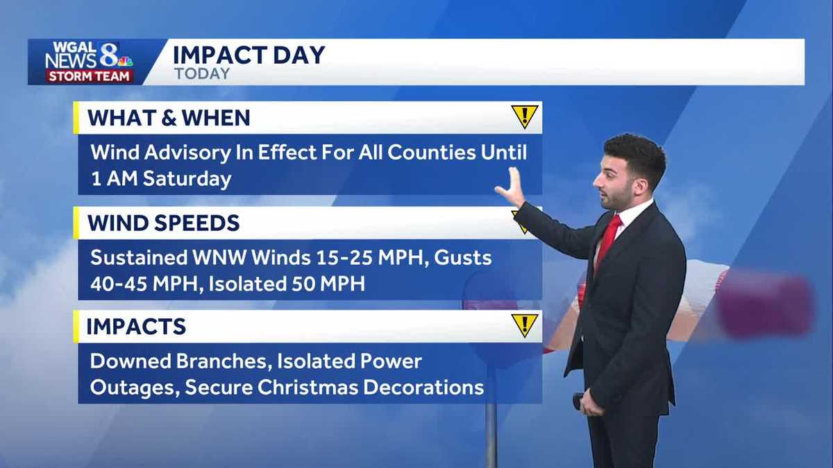
IMPACT DAY FOR WINDSIn the wake of a cold front that passed through the Valley, winds have died down briefly, but they will significantly elevate & remain gusty throughout the day. A Wind Advisory is in effect until 1 AM Saturday for the entire Susquehanna Valley. Sustained winds will be between 15-25 MPH, with gusts between 40-45 MPH. Be on the lookout for downed branches, isolated power outages, & secure your Christmas decorations this evening through Friday! Temperatures are in the 40s & 50s so far this afternoon, but temperatures will plunge to the 30s by late afternoon/early evening! A few rain/snow showers will still be possible during the afternoon.Tonight, skies will become partly to mainly clear with temperatures dropping to the low to mid 20s overnight. Winds will ease up, but it will still be a little bit breezy. Factoring in both the winds and the air temperatures, and that will make the wind chill/”feels like” temperatures feel as though they are in the teens!Saturday will be brisk to start, then building high pressure will ease the wind by afternoon. Highs will be seasonable near 40 degrees.Milder highs in the mid-40s return on Sunday and winds increase late, as a dry cold front passes.Monday will feature cooler highs in the mid-30s, then scattered rain showers are in store Tuesday, with temperatures close to 40 degrees. Christmas Eve looks dry and quiet.Another system will bring showers on Christmas Day into Friday. Precipitation should mainly fall as rain, as temperatures hover in the low 40s. We’ll keep you posted on any changes.Have a great day!~ Ryan
IMPACT DAY FOR WINDS
In the wake of a cold front that passed through the Valley, winds have died down briefly, but they will significantly elevate & remain gusty throughout the day. A Wind Advisory is in effect until 1 AM Saturday for the entire Susquehanna Valley. Sustained winds will be between 15-25 MPH, with gusts between 40-45 MPH. Be on the lookout for downed branches, isolated power outages, & secure your Christmas decorations this evening through Friday! Temperatures are in the 40s & 50s so far this afternoon, but temperatures will plunge to the 30s by late afternoon/early evening! A few rain/snow showers will still be possible during the afternoon.
Tonight, skies will become partly to mainly clear with temperatures dropping to the low to mid 20s overnight. Winds will ease up, but it will still be a little bit breezy. Factoring in both the winds and the air temperatures, and that will make the wind chill/”feels like” temperatures feel as though they are in the teens!
Saturday will be brisk to start, then building high pressure will ease the wind by afternoon. Highs will be seasonable near 40 degrees.
Milder highs in the mid-40s return on Sunday and winds increase late, as a dry cold front passes.
Monday will feature cooler highs in the mid-30s, then scattered rain showers are in store Tuesday, with temperatures close to 40 degrees. Christmas Eve looks dry and quiet.
Another system will bring showers on Christmas Day into Friday. Precipitation should mainly fall as rain, as temperatures hover in the low 40s. We’ll keep you posted on any changes.
Have a great day!
~ Ryan