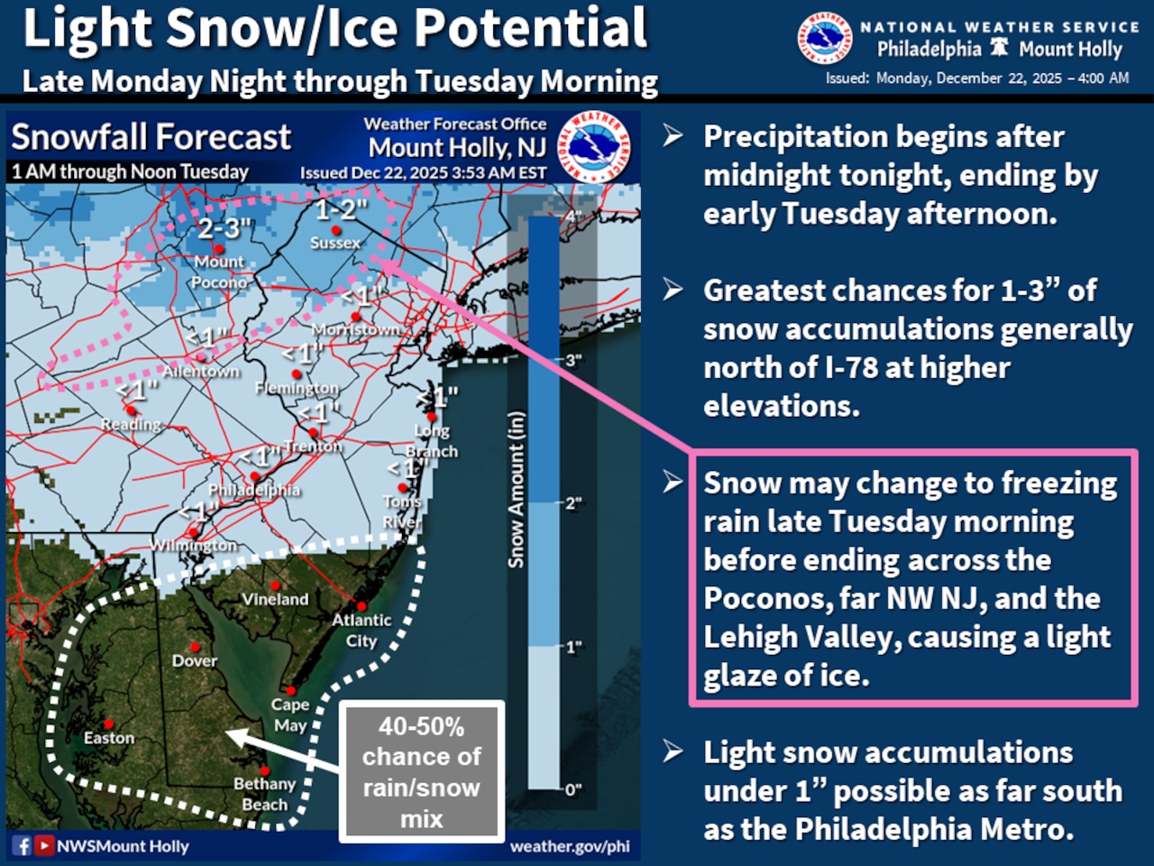
A weak clipper system is expected to bring light snowfall to the Lehigh Valley and Poconos early Tuesday morning, potentially causing slippery road conditions for holiday travelers.
Areas north of Interstate 78 have the highest chance of experiencing accumulating snow, with potential amounts ranging from less than an inch in the Lehigh Valley to 2-3 inches in the Pocono Mountains.
Increasing clouds are forecast for Monday, with highs reaching the upper 30s before dropping below freezing overnight.
The National Weather Service forecasts snow beginning before dawn Tuesday, with the highest probability of precipitation (70-80%) north of I-78. Tuesday’s high temperatures are forecast in the upper 30s to low 40s. Sleet could mix in before 10 a.m. Tuesday, followed by rain and snow likely into the early afternoon.
Travelers should be prepared for potentially hazardous conditions during Tuesday’s morning commute, particularly in higher elevation areas like the Poconos. Untreated roads may become slick, and visibility could be reduced during snowfall.
Winds are forecast from the west on Monday around 5 mph, becoming southerly overnight and Tuesday before shifting back to a westerly flow. Gusts could reach 20 mph Tuesday night.
The remainder of the week looks relatively mild, with Christmas Eve on Wednesday featuring mostly sunny skies and temperatures in the 40s. Winds are forecast from the northwest at 5 to 15 mph.
A weak clipper system on Christmas Day may bring brief light rain or sprinkles. Highs are forecast in the upper 30s and low 40s. Uncertainty increases for Friday and the weekend, with potential for a more significant precipitation system developing.
The weather service on Monday was predicting an 80% chance of rain Friday for the Lehigh Valley, with daytime highs around 50.
Long-term forecasts suggest an unsettled weather pattern may persist into the weekend, with increasing chances of precipitation and potential temperature fluctuations. Residents should stay informed about changing forecast conditions.
Current weather radar